
Courcelles-Chaussy
Courcelles-Chaussy | |
|---|---|
 The château of Urville | |
.svg) Coat of arms | |
Location of Courcelles-Chaussy  | |
 Courcelles-Chaussy  Courcelles-Chaussy | |
| Coordinates: 49°06′36″N 6°24′21″E / 49.11°N 6.4058°E | |
| Country | France |
| Region | Grand Est |
| Department | Moselle |
| Arrondissement | Metz |
| Canton | Le Pays Messin |
| Intercommunality | Haut Chemin - Pays de Pange |
| Government | |
| • Mayor (2008–2014) | Jean-Marie Gori |
| Area 1 | 19.02 km2 (7.34 sq mi) |
| Population (2021)[1] | 2,986 |
| • Density | 160/km2 (410/sq mi) |
| Time zone | UTC+01:00 (CET) |
| • Summer (DST) | UTC+02:00 (CEST) |
| INSEE/Postal code | 57155 /57530 |
| Elevation | 207–307 m (679–1,007 ft) (avg. 220 m or 720 ft) |
| 1 French Land Register data, which excludes lakes, ponds, glaciers > 1 km2 (0.386 sq mi or 247 acres) and river estuaries. | |
Courcelles-Chaussy (German: Kurzel an der Straße) is a commune in the Moselle department in Grand Est in north-eastern France.
See also
Gallery
-
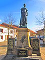 Courcelels-Chaussy monument
 -
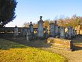 Courcelles-Chaussy Jewish cemetery
 -
 Courcelles-Chaussy Protestant cemetery


References
- ^ "Populations légales 2021". The National Institute of Statistics and Economic Studies. 28 December 2023.
![]() Media related to Courcelles-Chaussy at Wikimedia Commons
Media related to Courcelles-Chaussy at Wikimedia Commons
| International | |
|---|---|
| National | |
This Moselle geographical article is a stub. You can help Wikipedia by expanding it. |