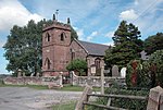
Plemstall

Plemstall is a hamlet in the civil parish of Mickle Trafford, Cheshire, England. It lies northeast of the village of Mickle Trafford.
The hamlet contains only a farm and former level crossing keeper's house in addition to the Grade I listed St Peter's Church.[1] The church stands on a slightly elevated area which was known as "The Isle of Chester" the surrounding area formerly being marsh. The church is believed to have been built on the site of Plegmund's hermitage, who is believed to have lived in there before he became Archbishop of Canterbury in AD 890.


St. Plegmund's well is also situated within the hamlet, on the edge of a low cliff about 220 yards (201 m) to the west of the church and to the east of one of the channels of the River Gowy.[2][3] It is one of two holy wells in west Cheshire.
See also
References
- ^ Historic England, "Church of St Peter, Mickle Trafford (1279021)", National Heritage List for England, retrieved 13 May 2012
- ^ Richards, Raymond (1947), Old Cheshire Churches, London: Batsford, p. 274, OCLC 719918
- ^ Fitzpatrick-Matthews, Keith, St Plegmund's Well: Topography, retrieved 9 October 2007[permanent dead link]
53°13′30″N 2°48′53″W / 53.2249°N 2.8148°W
External links
![]() Media related to Plemstall at Wikimedia Commons
Media related to Plemstall at Wikimedia Commons
