Tapanila
Appearance
Tapanila
Mosabacka | |
|---|---|
 Mosahalli sports hall in Tapanila | |
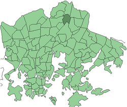
 Position of Tapanila within Helsinki | |
| Country | |
| Region | Uusimaa |
| Sub-region | Greater Helsinki |
| Municipality | Helsinki |
| District | Malmi |
| Area | 1.46 km2 (0.56 sq mi) |
| Population (1.1.2005) | 5,474 |
| • Density | 3,749/km2 (9,710/sq mi) |
| Postal codes | 00730, 00731 |
| Subdivision number | 392 |
| Neighbouring subdivisions | Ylä-Malmi, Tapaninvainio, Tapulikaupunki, Malmin lentokenttä, Puistola and Ala-Malmi. |
Tapanila (Swedish: Mosabacka) is a neighbourhood in Malmi district, Helsinki. Tapanila has approximately 5474 inhabitants (2005).[1] Tapanila has its own railway station.
It is known that there were few farm houses in Tapanila already in the 16th century. Back then Tapanila was one of the biggest villages in Helsinki area. In 1862, railroad between Hämeenlinna and Tapanila was built.[2] Tapanila was largely rebuilt from 1910–1935 based on Letchworth Garden City in England, the first in the Garden city movement. The area was annexed to Helsinki in 1946.
References
- ^ http://www.hel2.fi/tietokeskus/helsinki_alueittain_2005/503Malmi.pdf Information about Malmi and its subareas(in Finnish)
- ^ "Archived copy". Archived from the original on 2010-06-20. Retrieved 2009-12-22.
{{cite web}}: CS1 maint: archived copy as title (link) Tapanila.fi information in English
60°15′52″N 25°01′17″E / 60.2644°N 25.0214°E

