
Šipan
 View from Pakljena on Šipan | |
 | |
| Geography | |
|---|---|
| Location | Adriatic Sea |
| Archipelago | Elaphiti Islands |
| Area | 16.22 km2 (6.26 sq mi) |
| Length | 9.1 km (5.65 mi) |
| Width | 2.6 km (1.62 mi) |
| Highest elevation | 243 m (797 ft)[1] |
| Highest point | Velji Vrh[1] |
| Administration | |
| County | Dubrovnik-Neretva |
| Demographics | |
| Population | 419 (2011) |
Šipan (pronounced [ʃǐpan]) also Sipano (Italian: Giuppana) is the largest of the Elaphiti Islands, 17 km (11 mi) northwest of Dubrovnik, Croatia; separated from the mainland coast by the Koločepski Channel; area 16.22 km2 (6.3 sq mi);[2] The island is 9.1 km (5.7 mi) in length, and up to 2.6 km (1.6 mi) in width. It is the largest island in this group and its highest point is 243 m (797 ft) above sea level. Two limestone crests, the higher (Velji Vrh, 243 m) in the northeast and the lower in the southeast surround a dolomite depression, on which olives, figs, vine, carob-trees, almond-trees, oranges and citrus fruit are cultivated.
The island's population is 419 (2011).[3] There are two ports on the island, Suđurađ (San Giorgio) in the east, and Šipanska Luka (Porto Gippana) in the west. The island is also famed for its numerous palm tree species that grow on the island.
It was first mentioned by this name in documents of 1371.[4]
In 1426 it became part of the Republic of Ragusa.[5]
During the French Revolutionary Wars, the British Royal Navy referred to it as Zupano. On 17 June 1813 a landing party of marines and seamen from HMS Saracen captured the French garrison.
Gallery
-
 Suđurađ
 -
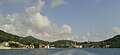 Šipanska Luka
 -
 Vice Stjepović-Skočibuha House
 -
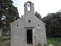
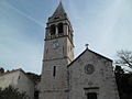
 Church on Pakljena
 -
 Early medieval St. Stephen Church in Suđurađ
 -
 Church in Suđurađ
 -
 House of Getaldić
 -
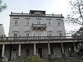
 School, library and administrative center
 -
 Church
 -
 One of old noble houses
 -

-
 Rector's Palace on Šipan
 -
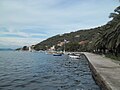
 Near of Šipanska Luka
 -
 Šipanska Luka coast
 -
 House in Šipanska Luka
 -
 Church in Šipanska Luka


See also
References
- ^ a b Glamuzina & Glamuzina 1999, p. 89.
- ^ Duplančić Leder, Tea; Ujević, Tin; Čala, Mendi (June 2004). "Coastline lengths and areas of islands in the Croatian part of the Adriatic Sea determined from the topographic maps at the scale of 1 : 25 000" (PDF). Geoadria. 9 (1). Zadar: 5–32. doi:10.15291/geoadria.127. Retrieved 25 December 2019.
- ^ Statistical Yearbook of the Republic of Croatia 2017 (PDF) (in Croatian and English). Zagreb: Croatian Bureau of Statistics. December 2017. p. 45. ISSN 1333-3305. Archived from the original (PDF) on 13 November 2018. Retrieved 23 May 2018.
- ^ Naklada Naprijed, The Croatian Adriatic Tourist Guide, p. 369, Zagreb (1999), ISBN 953-178-097-8
- ^ Southeastern Europe under Ottoman Rule, 1354–1804 at Google Books
Bibliography
- Glamuzina, Martin; Glamuzina, Nikola (1999). "Suvremena geografska problematika otoka Lopuda i Koločepa" [Recent Geographical Problematics of the Lopud and Koločep Islands] (PDF). Geoadria (in Croatian). 4 (1): 89–100. Retrieved 25 December 2019.
External links
 Media related to Šipan at Wikimedia Commons
42°43′43″N 17°52′33″E / 42.7286°N 17.8758°E
This Dubrovnik-Neretva County geography article is a stub. You can help Wikipedia by expanding it. |