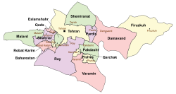
Shahriar County
Shahriar County
شهرستان شهریار | |
|---|---|
 Counties of Tehran Province | |
 Location of Tehran Province in Iran | |
| Country | |
| Province | Tehran |
| Capital | Shahriar |
| Bakhsh (Districts) | Central District |
| Area | |
| • Total | 335.9 km2 (129.7 sq mi) |
| Population (2016)[1] | |
| • Total | 744,210 |
| • Density | 2,200/km2 (5,700/sq mi) |
| Time zone | UTC+3:30 (IRST) |
| • Summer (DST) | UTC+4:30 (IRDT) |
| Year | Pop. | ±% |
|---|---|---|
| 2006 | 518,661 | — |
| 2011 | 624,440 | +20.4% |
| 2016 | 744,210 | +19.2% |
| amar.org.ir Excluding areas under the jurisdiction of the county in previous censuses. | ||
Shahriar County (Persian: شهرستان شهریار) is a county in Tehran Province in Iran. The capital of the county is Shahriar. At the 2006 census, the county's population (including those portions later split off to form Malard County and Qods County) was 1,044,707, in 273,826 families; excluding those portions, the population was 516,022, in 134,378 families.[2] The county has one district: the Central District. The county has seven cities: Shahriar, Sabashahr, Vahidieh, Shahedshahr, Ferdowsieh, Baghestan, and Andisheh.
References
- ^ "National census 2016". amar.org.ir. Retrieved 2017-03-14.[]
- ^ "Census of the Islamic Republic of Iran, 1385 (2006)" (Excel). Statistical Center of Iran. Archived from the original on 2011-09-20.
- اطلس گیتاشناسی استانهای ایران [Atlas-e Gitashenasi-e Ostanha-ye Iran] (Gitashenasi Province Atlas of Iran)
35°39′33″N 51°03′34″E / 35.659066°N 51.059527°E

