
Brandeston
| Brandeston | |
|---|---|
 | |
 Brandeston Location within Suffolk | |
| Population | 296 (2011)[1] |
| OS grid reference | TM2460 |
| Civil parish |
|
| District | |
| Shire county | |
| Region | |
| Country | England |
| Sovereign state | United Kingdom |
| Post town | WOODBRIDGE |
| Postcode district | IP13 |
| Dialling code | 01728 |
| Police | Suffolk |
| Fire | Suffolk |
| Ambulance | East of England |
 | |

"Brandeston is a village in Suffolk, England on the River Deben 11 miles (18 km) northeast of Ipswich. Brandeston is west of Kettleburgh and northwest of Hoo Green. It is a Parish in Plomesgate district and 3½ miles SW of Framlingham r. station."[2]
"19th century Brandeston Hall stands beside the church; for many centuries, its predecessor on the site was home to the Revett family, but it is now a public school."[3]
There is a pub called The Queen at the centre of the village.
An overall average of house prices stood at £376,286 on 6 March 2017 from data produced by the Land Registry, more expensive than the nearby Kettleburgh, Earl Soham and Framsden.[4]
History
Brandeston Hall the largest building in the village, is now the preparatory department of nearby Framlingham College. It was largely destroyed in a fire in 1847 and rebuilt as an exact replica by its then owner Charles Austin QC, who married Harriet Jane Ingilby of Ripley Castle and died at the hall.
Sutton Hoo, a few miles away from Brandeston, is the ceremonial burial place of the first English kings, who led their people through the misty marshlands of what is now the River Deben and established their first settlements on its banks.[5]
The number of households from the period 1831 to 1961 fluctuates with little pattern. The data has no huge anomalies except for one but yet no clear relationship. For example, the one large anomaly in the data is the period from 1831 to 1851. In 1831 there were 64 occupied households yet in 1841 there were 108 before declining again to 66 households occupied in 1851.
The 20th century map of Brandeston from Vision of Britain shows Brandeston and the surrounding villages, including Cretingham, Hoo and Kettleburgh.
Churches
The mediaeval parish church (the Church of All Saints) is a Gothic building, with square tower. There is an Independent chapel, built in 1838, capable of accommodating 400 persons.[6]In 1602, the Chancel was described as ruinous and from 1861 to 1863 restoration of the Church began.[7]
The parish retains a parish church that bears the memory of its 17th Century Vicar who, after 50 years of service, was tried and wrongly hanged for witchcraft. His figure can be seen on the village sign, hanging from the gallows.[8]
Demographic

According to the 2011 Census, there were 144 males and 152 females living in Brandeston.[9] The median age of residents in Brandeston is 48 and 49.3% of all usual residents are in the age range of 45–74, according to the Office of National Statistics.[10]
Occupations have been grouped by status from 1831 data. It shows that there were 15 people categorised as Employers & Professionals, 31 as Middling Sorts, 70 as Labourers & Servants and 22 as Others.[11] The graph titled 'Occupational structure for Brandeston in 1881' shows the dominance of men working during this time. The main occupational sector for men was by far agriculture, the second most popular sector was persons working with houses, furniture and decorations, and thirdly those working with animals. The women's occupational structure is very different with unknown occupations, persons without specified occupations and domestic offices or services all being the main sectors that they worked in.
Occupations are obviously very different than what they were in 1831. For example, out of 134, 42 work in Professional occupations, 27 work in Associate Professional and Technical Occupations, 21 as Managers, Directors and Senior Officials, 14 in Administrative and Secretarial Occupations, 14 in Skilled Trades Occupations, 7 in Caring and Leisure Occupations, 6 in Sales and Customer Service Occupations, 2 in Elementary Occupations and 1 in Process, Plant and Machine Operatives.[12]
General health in Brandeston is mostly 'Very Good Health' with a high majority of 162 usual residents under this category, 106 under 'Good Health', 23 under 'Fair', 5 under 'Bad' and no residents in the 'Very Bad Health' category.[13] This suggests that Brandeston is a healthy and non-polluted place
In Fiction
Brandeston features prominently in Ronald Bassett 's1966 novel Witchfinder General and in the 1968 film of the same name, although the latter was not filmed in the village.
Gallery
-
 The Queens Head Inn, Brandeston
 -
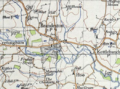 20th century map of Brandeston, Suffolk
 -
 Occupational structure for Brandeston in 1881
 -


References
- ^ "Parish population 2011". Retrieved 14 September 2015.
- ^ Wilson, John Marius (1870–72). Imperial Gazetteer of England and Wales. Edinburgh: A. Fullerton & Co.
- ^ Knott, Simon (June 2008). "All Saints, Brandeston". Suffolk Churches. Retrieved 5 March 2017.
{{cite web}}: Cite has empty unknown parameter:|dead-url=(help) - ^ "House prices in Brandeston, Woodbridge, Suffolk". Right Move. 6 March 2017. Retrieved 21 March 2017.
{{cite web}}: Cite has empty unknown parameter:|dead-url=(help) - ^ "Brandeston – A Brief History". Archive Brandeston. Retrieved 5 March 2017.
{{cite web}}: Cite has empty unknown parameter:|dead-url=(help) - ^ "Brandeston, Suffolk". GENUKI. The National Gazetteer of Great Britain and Ireland. 1868. Retrieved 21 March 2017.
{{cite web}}: Cite has empty unknown parameter:|dead-url=(help) - ^ "Parish: Brandeston" (PDF). Suffolk Heritage Explorer. Retrieved 21 April 2017.
{{cite web}}: Cite has empty unknown parameter:|dead-url=(help) - ^ "Brandeston Profile" (PDF). Health and Wellbeing: Suffolk. 21 June 2016. Retrieved 25 April 2017.
{{cite web}}: Cite has empty unknown parameter:|dead-url=(help) - ^ "Key Figures for 2011 Census: Key Statistics". Neighbourhood Statistics. Office for National Statistics. Retrieved 2 February 2017.
- ^ "Age structure in Brandeston, 2011". Office of National Statistics. Retrieved 21 February 2017.
{{cite web}}: Cite has empty unknown parameter:|dead-url=(help) - ^ "1831 occupations grouped by Status". A Vision of Britain through Time. GB Historical GIS / University of Portsmouth. Retrieved 17 February 2017.
{{cite web}}: Cite has empty unknown parameter:|dead-url=(help) - ^ "Occupation, 2011". Neighbourhood Statistics. Office for National Statistics. 2011. Retrieved 21 April 2017.
{{cite web}}: Cite has empty unknown parameter:|dead-url=(help) - ^ "General Health, 2011". Neighbourhood Statistics. Office for National Statistics. 2011. Retrieved 21 March 2017.
{{cite web}}: Cite has empty unknown parameter:|dead-url=(help)
![]() Media related to Brandeston at Wikimedia Commons
Media related to Brandeston at Wikimedia Commons
This Suffolk location article is a stub. You can help Wikipedia by expanding it. |