Broughton, Oxfordshire
| Broughton | |
|---|---|
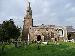
 St Mary the Virgin parish church | |
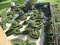
 Formal gardens at the castle which remains the feudal manor of the area, although feudal laws no longer apply such as manorial courts | |
| Area | 3.94 km2 (1.52 sq mi) |
| Population | 286 (2011 Census) |
| • Density | 73/km2 (190/sq mi) |
| OS grid reference | SP4238 |
| Civil parish |
|
| District | |
| Shire county | |
| Region | |
| Country | England |
| Sovereign state | United Kingdom |
| Post town | Banbury |
| Postcode district | OX15 |
| Dialling code | 01295 |
| Police | Thames Valley |
| Fire | Oxfordshire |
| Ambulance | South Central |
| UK Parliament | |
Broughton is a small village and civil parish in northern Oxfordshire, England, about 2.5 miles (4 km) southwest of Banbury. The 2011 Census recorded the parish's population as 286.[1]
History
Broughton's Church of England Parish Church of St Mary the Virgin was built in about 1300 in a style that is transitional from Early English to Decorated Gothic.[2] The church is in the grounds of Broughton Castle, the 14th- to 16th-century country house the seat of the ancestral line of the Lords Saye and Sele (the Fiennes family) restored using the consultancy of architect George Gilbert Scott.
Broughton Rectory was rebuilt in 1694.[3] It was altered three times in the 19th century: firstly by Richard Pace of Lechlade in 1808, and then with extensions by S.P. Cockerell in 1820 and H.J. Underwood in 1842.[3]
The Domesday Book records that in 1086 Broughton parish had two watermills. By 1444 there were at least three, one of which was a fulling mill.> By 1685 there was a second fulling mill, and both mills supplied the local woollen industry. Fulling and cloth-dyeing remained local industries until early in the 20th century.[4]
In the 17th century Broughton's agriculture was predominantly pasture for cattle and sheep, which has given to the parish such field names as Dairy Ground, Grazing Ground and New Close Pasture. Improved crop rotation in the agricultural revolution increased arable farming in the parish, with crops being diversified in the 18th century to include clover, flax, hops, sainfoin and woad. Some of these crops have given place names to the parish such as Sandfine Wood, Sandfine Road and Woadmill Farm. Woad was still grown in 1827, when it was used locally for dyeing wool.[4]
Broughton has a pair of Gothic Revival almshouses that were built in 1859.[3]
Amenities
Broughton has one public house, the Saye and Sele Arms.[5]
References
- ^ "Area: Broughton (Parish): Key Figures for 2011 Census: Key Statistics". Neighbourhood Statistics. Office for National Statistics. Retrieved 18 March 2015.
- ^ Sherwood & Pevsner 1974, pp. 490–492.
- ^ a b c Sherwood & Pevsner 1974, p. 498.
- ^ a b Lobel & Crossley 1969, pp. 85–102
- ^ Saye and Sele Arms
Sources
- Lobel, Mary D; Crossley, Alan, eds. (1969). A History of the County of Oxford. Victoria County History. Vol. 9: Bloxham Hundred. London: Oxford University Press for the Institute of Historical Research. pp. 85–102. ISBN 978-0-19722-726-8.
{{cite book}}: Invalid|ref=harv(help) - Sherwood, Jennifer; Pevsner, Nikolaus (1974). Oxfordshire. The Buildings of England. Harmondsworth: Penguin Books. pp. 490–492, 498. ISBN 0-14-071045-0.
{{cite book}}: Invalid|ref=harv(help)
External links
![]() Media related to Broughton, Oxfordshire at Wikimedia Commons
Media related to Broughton, Oxfordshire at Wikimedia Commons

