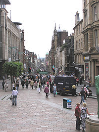
Buchanan Street

Buchanan Street is one of the main shopping thoroughfares in Glasgow, the largest city in Scotland. It forms the central stretch of Glasgow's famous shopping district with a generally more upmarket range of shops than the neighbouring streets: Argyle Street, and Sauchiehall Street.
History

Buchanan Street was first feued in 1777 and was named after a wealthy Tobacco Lord, Andrew Buchanan of Buchanan, Hastie, & Co. He was proprietor of the ground on which it was formed from Argyle Street as far North as Gordon Street.
The land around the north and northeast of Buchanan Street was formerly home to Buchanan Street railway station. Originally owned by the Caledonian Railway, then the London Midland and Scottish Railway and finally British Railways, Buchanan Street station was closed in 1966. It was not rated highly either for location, architecture or convenience. Glasgow Queen Street station is immediately to the East of Buchanan Street, and the Buchanan Street station on the Glasgow Subway (which also serves Queen Street Station) is underneath the North end of Buchanan Street. The St. Enoch station of the subway is at the South end of Buchanan Street.
Buchanan bus station was opened at the Northern end in 1978, at the same time as the street itself was pedestrianised between Bath Street and Argyle Street. The most Northern reaches of the street were badly dilapidated following the closure of the Glasgow NAAFI and the railway station, but this was addressed in the 1990s by the construction of the Glasgow Royal Concert Hall in 1990, and the adjoining Buchanan Galleries shopping mall in 1998. In 1999, the entire street was repaved with high quality granite stonework and striking blue neon lighting. The combination of impressive Victorian architecture and modern urban design won Buchanan Street the Academy of Urbanism 'Great Street Award' 2008, beating both O'Connell Street in Dublin and Regent Street/Portland Place, London.[1] The area between Argyle Street and St. Vincent Street is particularly popular with buskers.
The bus station was also substantially redeveloped following the closure of the bus station at Anderston, and became the principal bus terminus in the city centre. It was renamed simply as "Buchanan Bus Station", since the street itself now terminated some distance away due to the building of the Concert Hall.
In May 2002 the Prime Minister Tony Blair unveiled a statue of the late politician Donald Dewar at the northern end of the street. The statue was criticized for its ugliness, and was repeatedly vandalized, leading to it being placed on a raised plinth to protect it.[2]
In March 2011, it was revealed that Land Securities had secured planning permission to rebuild the last remaining derelect site on the northern end of Buchanan Street opposite the Buchanan Galleries complex - the new buildings will incorporate new residential and retail space, Bringing some big names to Glasgow's retail offering, including Scotland's first Forever 21, Sketchers as well as Scotland's largest Paperchase, and many more. This new development will extend westward onto West Nile Street, removing the former General Accident office block, and the vacant land on the corner of Bath Street. The development was opened to the public in March 2013. http://www.buchananquarter.co.uk/
Location
It runs south from the junction with Sauchiehall Street. At its north end are the Buchanan Galleries and the Glasgow Royal Concert Hall. The Princes Square mall and a flagship branch of the House of Fraser department store are opposite one another further south, and the street meets Argyle Street at the south, just north of St. Enoch Square. Buchanan Street is now entirely pedestrianised, but the streets that cross it (Bath Street, George Street, St. Vincent Street, and Argyle Street) are not.
Buchanan Street cuts through Nelson Mandela Place, which was renamed by the Labour city council from St George's Place, the address of the South African Consulate, as a protest to the ANC activist Nelson Mandela being a political prisoner of the South African Apartheid regime.[3] At the time and even after becoming the first black president of South Africa, Prime Minister Margaret Thatcher considered him and the ANC to be "terrorists".[4] Buchanan Street is also adjacent to St George's-Tron Church and the Glasgow Stock Exchange building, and Royal Exchange Square, which now houses the Gallery of Modern Art.


Retail
Buchanan Street is renowned for its variety in high street shopping, including flagship stores, with rents on the street being as much as £250 per square foot, making it the 6th most expensive street in the United Kingdom for retail rent, only surpassed by 5 streets in London. Buchanan Street is also the second busiest shopping thoroughfare, second only to Oxford Street in London. Glasgow has been recognized for being the second best shopping destination in the United Kingdom, after London, since 2008.
Culture
- Glasgow Royal Concert Hall
- Gallery of Modern Art (GoMA) in Royal Exchange Square
- The Lighthouse Centre for Architecture, Design and the City, is located off Buchanan Street, on Mitchell Lane.
- Dr Who Tardis, located half way up from St Enoch Square
See also
References
- ^ Academy of Urbanism Awards 2008 http://www.academyofurbanism.org.uk/awards.htm
- ^ "Dewar statue removed for repairs". BBC News. 10 October 2005.
- ^ "http://www.theglasgowstory.com/image.php?inum=TGSA05067". Glasgow City Council.
{{cite web}}: External link in|title= - ^ Anthony, Bevins (9 July 1996). "From 'terrorist' to tea with the Queen". London: The Independent.

