Chaldon
| Chaldon | |
|---|---|
 Church of SS. Peter and Paul | |
 Glebe House, Chaldon | |
| Area | 4.72 km2 (1.82 sq mi) |
| Population | 1,735 (Civil Parish 2011)[1] |
| • Density | 368/km2 (950/sq mi) |
| OS grid reference | [TQ31856 TQ31856] |
| • London | 15.8 miles (25.4 km) |
| Civil parish |
|
| District | |
| Shire county | |
| Region | |
| Country | England |
| Sovereign state | United Kingdom |
| Post town | CATERHAM |
| Postcode district | CR3 |
| Dialling code | 01883 |
| Police | Surrey |
| Fire | Surrey |
| Ambulance | South East Coast |
| UK Parliament | |
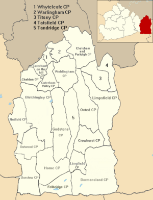
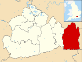
Chaldon is a village in Surrey, England, high on the North Downs immediately west of Caterham. Chaldon is centred 1.5 miles (2.4 km) WSW of Caterham on the Hill, 15.8 miles (25.4 km) south of London and falls within the boundaries of Tandridge district, just south of the border with the London Borough of Croydon
History
Etymology and Dark Ages
Chalvedune is the first written record of the place in 675 AD, meaning the hill (down) where calves were pastured, in a grant of land to Chertsey Abbey.[2] Prior to this period of human history, White Hill on the borders of Chaldon and Caterham has yielded neolithic flints.[3]
The village lay within the Anglo-Saxon administrative division of Wallington hundred.[4]
Middle Ages
In the Domesday Book the manor of Calvedone appears in Wallington hundred rendering £4 to its lord Ralph Fitz Turold holding it as was most of the hundred of Bishop Odo of Bayeux.[5] Prior to the conquest it had been held by the Saxon lord Dernic of King Edward. It consisted of two hides, land for two lord's plough teams and a church.[6] In medieval times the parish included a narrow strip of land below the southern foot of the Downs and a wedge of land to the north of the church that in the 19th century were transferred to Bletchingley and Coulsdon respectively[2] — these are omitted from this article.
An inscribed stone dedicates a pond for use by residents not animals dated to the late 18th or early 19th century illustrates the lack of water in the village during summer months.[2] St Catherine's south chancel chapel in the church became devoted to the memory of Christian Hane (d.1752) of an aedicular type with a white stone rectangular panel flanked by Doric pilasters with red marble inlay, swan-neck pediment and crowning shell.[7]
Church of St Peter and St Paul

The Grade I architecturally listed church of Saints Peter and Paul (built before 1086 AD) contains a large wall painting of around 1170 depicting images of the ways of salvation and damnation and their result [a]
Post industrial revolution
Under Rev. James Legrew, the tithes were commuted for £335. 11s 3d, however as rector retaining a glebe of 31 acres, with a glebe house. A tower and spire were added to the church in 1843[4] from a bellcote before.[3] Given its steep, dry landscape on top of the North Downs Area of Outstanding Natural Beauty, Chaldon did not develop new homes substantially even in the 19th and 20th centuries; though replacements to farmhouses were built in this period. In 1848 the population was 197[4] and the population in 1901 was only 266[3] and it consisted of little more than "the church and six scattered farms".[2] By 1911 Viscount Hylton connected his farms and cottages with the East Surrey Water Company's mains; otherwise the supply depended upon the shallow wells and ponds, filled in a wet season and empty in a dry one.[3]
Geography
Elevations, geology and soil
Chaldon has received by some locals the epithet "Little Switzerland" because of the microclimate resulting in heavier snowfall here than in other parts of the region when there is snow in Winter.[citation needed] Caterham-on-the-Hill is centred 1.5 miles (2.4 km) ENE of Chaldon and London is 15.8 miles (25.4 km) north.[8]
Local Government
Historical
The civil parish of Chaldon fell within the Reigate Poor Law Union upon its creation in 1837, subsequently coming under control of Reigate Rural Sanitary District from 1875 and Reigate Rural District from 1894 until its abolition in 1933.[9] Thereafter it became part of the Caterham & Warlingham Urban District until 1 April 1974 when the major local government reorganisation brought Chaldon under the newly formed Tandridge District.
For the purposes of parliamentary elections, Chaldon became part of the Eastern Division of the Surrey county constituency upon its creation in 1832. It moved to the Mid Division in 1867, to the South Eastern Division in 1885, to the Reigate Division in 1918 and to the East Surrey Division in 1948 where it remains to this day.[9]
Current authorities

Surrey County Council, headquartered in Kingston, elected every four years, has one representative councillor as follows:
| Election | Member[10] |
Ward | |
|---|---|---|---|
| style="background-color: Template:Liberal Democrats (UK)/meta/color" | | 2009 | John Alexander Orrick | "Caterham Hill"; includes in this context only Chaldon. |
Chaldon has a representative on Tandridge District Council, headquartered in Oxted:
| Election | Member[11] | Ward | |
|---|---|---|---|
| style="background-color: Template:Conservative Party (UK)/meta/color" | | 2011 | Patrick Cannon | Chaldon |
Civil parish
Chaldon's residents can participate in the Civil Parish Council with five parish councillors and the parish clerk.[12]
Demography and housing
In 2001, there were 1,821 residents in 639 households of which 18.8% were aged over 65; 4.5% of the population were in full-time further education; 70.9% of all men were economically active whereas 3.2% were unemployed, 5.2% worked part-time; 58.9% of all women were economically active whereas 1.2% were unemployed, 37.7% worked part-time.[13]
As to ethnicity, 97.3% of the population identified themselves as being white, 0.5% as mixed, 1.0% as of Indian descent, and 1.5% as other of the three main categories.[13]
In terms of religion, 80.1%% of the population responded as being Christian, 0.6% as Muslim, 2.0% other religions, 11.1% as atheist and 6% declined to answer.[13]
Chaldon's economy is predominantly a service sector economy reflected by the lower end of the official categorisation table of occupation given, compiled from the 2001 census:
| Category | Number of adults in category in 2001 | Percentage of those aged 16–74 |
|---|---|---|
| Lower supervisory and technical occupations | 39 | 2.9% |
| Semi-routine occupations | 83 | 6.2% |
| Routine occupations | 39 | 2.9%[13] |
Whereas in this census, 24% of the population worked in lower managerial and professional occupations and 7.9% in higher professional occupations.[13]
| Output area | Detached | Semi-detached | Terraced | Flats and apartments | Caravans/temporary/mobile homes | shared between households[1] |
|---|---|---|---|---|---|---|
| (Civil Parish) | 528 | 78 | 22 | 15 | 1 | 0 |
The average level of accommodation in the region composed of detached houses was 28%, the average that was apartments was 22.6%.
| Output area | Population | Households | % Owned outright | % Owned with a loan | hectares[1] |
|---|---|---|---|---|---|
| (Civil Parish) | 1,735 | 644 | 48.9% | 44.4% | 472 |
The proportion of households in the civil parish who owned their home outright compares to the regional average of 35.1%. The proportion who owned their home with a loan compares to the regional average of 32.5%. The remaining % is made up of rented dwellings (plus a negligible % of households living rent-free).
Landmarks
Along the north street, Church Lane, is a line of houses ending with the Church Green. Here is a close cluster of five listed buildings including the two most highly ranked listed buildings plus farm outbuildings. This area forms a conservation area. Its booklet with hand-drawn illustrations was produced in 1975, year of European Architectural Heritage.[2] On Roffes Lane at no. 18 and no. 20 are two unusual Arts and Crafts elm timber framed and panelled cottages by the architect Ernest George Trobridge. There was a third at no. 22; however, this was demolished in 2015 and no. 18 is under threat from developers.[14]
Church of St Peter and St Paul
See above.
Chaldon Court
This Grade II* listed timber-framed building was built in the 14th century and encased in brick and flint in the 18th century; its door is of the Tudor period.[15] Its large gable ends have a large window housing a third floor; however, its extension at a right-angle has instead two taller storeys, slightly lower in height.[2]
Surrey National Golf Course
Although almost a plateau, the highest part of Chaldon is White Hill, which overlooks Caterham and south-east London beyond and is occupied by Surrey National Golf Course.
Notes
- ^ Executed in accordance with a scheme originating in the Eastern church, preserved to us in the 'Guide to Painting of the Greek Church,' as used by the monk-painters of the monasteries of Mount Athos whose title is "The Ladder of the Salvation of the Human Soul and the Road to Heaven"
References
- ^ a b c Key Statistics; Quick Statistics: Population Density United Kingdom Census 2011 Office for National Statistics Retrieved 21 November 2013
- ^ a b c d e f Chaldon Explored, Appraisal on the Designation of Chaldon's Conservation Area: www.tandridge.gov.uk/Tandridge%20District%20Council/Planning/ChaldonExplored[1].pdf Tandridge District Council
- ^ a b c d H.E. Malden (editor) (1912). "Parishes: Chaldon". A History of the County of Surrey: Volume 4. Institute of Historical Research. Retrieved 5 November 2012.
{{cite web}}:|author=has generic name (help) - ^ a b c H.E. Malden (editor) (1912). "Parishes: Chaldon". A History of the County of Surrey: Volume 4. Institute of Historical Research. Retrieved 6 November 2012.
{{cite web}}:|author=has generic name (help) - ^ H.E. Malden (editor) (1912). "Parishes: Chaldon". A History of the County of Surrey: Volume 4. Institute of Historical Research. Retrieved 19 November 2012.
{{cite web}}:|author=has generic name (help) - ^ Anna Powell-Smith. "Chaldon | Domesday Book". Domesdaymap.co.uk. Retrieved 27 June 2016.
- ^ Church of St Peter and St Paul Historic England. "Details from listed building database (1029813)". National Heritage List for England. Retrieved 5 November 2012.
- ^ "UK Grid Reference Finder". Gridreferencefinder.com. Retrieved 27 June 2016.
- ^ a b F. Youngs, Local Administrative Units: Southern England (London: Royal Historical Society, 1979), p. 476
- ^ "Surrey's County councillors". Surrey County Council. 3 February 2012. Retrieved 2 March 2012.[permanent dead link]
- ^ "Councillors". Councillors.tandridge.gov.uk. Retrieved 27 June 2016.
- ^ "Your Councillors". Chaldon Civil Parish Council. 1 May 2008. Retrieved 2 March 2012.
- ^ a b c d e [1][dead link]
- ^ "Tandridge District Council - Application Details". Tdcws01.tandridge.gov.uk. Retrieved 27 June 2016.
- ^ Chaldon Court Grade II* ListingHistoric England. "Details from listed building database (1029812)". National Heritage List for England. Retrieved 5 November 2012.

