Civitanova Marche
Civitanova Marche | |
|---|---|
| Comune di Civitanova Marche | |
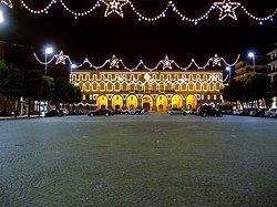
 Palazzo Cesarini-Sforza, the Townhall of Civitanova Marche, decorated for the Christmas feasts | |
 Civitanova within the Province of Macerata | |
| Country | Italy |
| Region | Marche |
| Province | Macerata (MC) |
| Frazioni | Civitanova Alta, Fontespina, Maranello, Risorgimento, San Marone, Santa Maria Apparente |
| Government | |
| • Mayor | Tommaso Claudio Corvatta (PD) |
| Area | |
| • Total | 45.8 km2 (17.7 sq mi) |
| Elevation | 3 m (10 ft) |
| Population (31 August 2015)[2] | |
| • Total | 41,395 |
| • Density | 900/km2 (2,300/sq mi) |
| Demonym | Civitanovesi |
| Time zone | UTC+1 (CET) |
| • Summer (DST) | UTC+2 (CEST) |
| Postal code | 62012 |
| Dialing code | 0733 |
| Patron saint | San Marone |
| Saint day | August 18 |
| Website | Official website |
Civitanova Marche is a comune (municipality) in the Province of Macerata in the Italian region Marche, located about 40 kilometres (25 miles) southeast of Ancona and about 25 km (16 mi) east of Macerata.
History

Civitanova was founded probably around the 8th century BC as Cluana by the Piceni Italic tribe, at the mouth of the Chienti river. The Romans captured it in 268 BC, and, in 50 AD, founded a new settlement, Cluentis Vicus (the current frazione of Civitanova Alta) on a hill near the sea. During the Barbaric invasion, old Cluana was destroyed by the Visigoths and much of the population took refuge in the Vicus.
In the Middle Ages it was under the Aldonesi, da Varano, Malatesta, Sforza and Visconti. In 1440, under Francesco Sforza, a new line of walls was built, while a fortress was erected to protect the port. The city, attacked by Turk pirates and struck by inner feuds and by the plague, started to decay from the 16th century. In 1551 pope Julius III ceded it to the Cesarini family. Made Dukes by pope Sixtus V, the Cesarini enlarged the town with new walls, roads and palazzi, although the population's conditions remained generally miserable. Civitanova had 6,057 inhabitants in 1782.
After the Italian unification, Porto Civitanova and Civitanova Alta became a single commune in 1938. It is now a renowned vacation resort.
Churches
- San Marone
- San Pietro Apostolo (previously called Santi Pietro e Marone)
- Cristo Re
- Santa Maria Apparente
- Santissimo Sacramento
- San Francesco
- San Paolo Apostolo
- Sant'Agostino
- Madonna degli Angeli
- San Giovanni Battista (once known as the Chiesa dei Padri Cappuccini)
Geography
Civitanova Marche borders the municipalities: Montecosaro, Porto Sant'Elpidio, Potenza Picena and Sant'Elpidio a Mare.[3] It counts the hamlets (frazioni) of Civitanova Alta, Fontespina, Maranello, Risorgimento, San Marone and Santa Maria Apparente.
Demographics

Gallery
-
San Marone church
-
Villa Conti
International relations
Civitanova Marche is twinned with:[4]
 Esine, Italy, since 1989 [4]
 Šibenik, Croatia, since 2002 [4]
 San Martín, Argentina, since 1990[4]
 Skawina, Poland, since 2005[4]
See also
References
- ^ "Superficie di Comuni Province e Regioni italiane al 9 ottobre 2011". Italian National Institute of Statistics. Retrieved 16 March 2019.
- ^ All demographics and other statistics: Italian statistical institute Istat.
- ^ 42402 Civitanova Marche on OpenStreetMap
- ^ a b c d e "Civitanova Marche - Twin Towns". © 2008 Comune di CIVITANOVA MARCHE - Piazza XX Settembre n.93 - 62012 - Civitanova Marche (MC). Retrieved 2008-12-04.


