
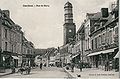
Doullens
Doullens | |
|---|---|
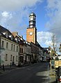
 The town hall in Doullens | |
 Coat of arms | |
Location of Doullens  | |
 Doullens  Doullens | |
| Coordinates: 50°09′27″N 2°20′29″E / 50.1575°N 2.3414°E | |
| Country | France |
| Region | Hauts-de-France |
| Department | Somme |
| Arrondissement | Amiens |
| Canton | Doullens |
| Intercommunality | CC Territoire Nord Picardie |
| Government | |
| • Mayor (2001–2015) | Christian Vlaeminck |
| Area 1 | 33.4 km2 (12.9 sq mi) |
| Population (2006) | 6,820 |
| • Density | 200/km2 (530/sq mi) |
| Time zone | UTC+01:00 (CET) |
| • Summer (DST) | UTC+02:00 (CEST) |
| INSEE/Postal code | 80253 /80600 |
| Elevation | 52–152 m (171–499 ft) (avg. 64 m or 210 ft) |
| 1 French Land Register data, which excludes lakes, ponds, glaciers > 1 km2 (0.386 sq mi or 247 acres) and river estuaries. | |
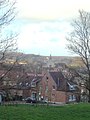
Doullens is a commune in the Somme department in Hauts-de-France in northern France.
Its inhabitants are called Doullennais and Doullennaises.[1]
Geography
Doullens is situated on the N25 road, in the northern part of the department, straddling the river Authie, the border with the Pas-de-Calais. Doullens is practically mid-way on the intersection of these axes :
- Abbeville - Arras
- Amiens - Saint-Pol-sur-Ternoise
- Crécy-en-Ponthieu - Bapaume
- Auxi-le-Château - Acheux-en-Amiénois
History
- Doullens, the ancient Dulincum, was seat of a viscountship under the counts of Vermandois then of Ponthieu (Hare) and an important stronghold in the Middle Ages.[2]
- In 1225, the town became part of France.
- In 1475 it was burnt by Louis XI for openly siding with the Duke of Burgundy.[2] It received its name Doullens-le-Hardi from its gallant defense in 1523 against the Anglo-Burgundian army.
- In 1595 it was besieged and occupied by the Spaniards, who massacred the entire population. It was restored to France by the Peace of Vervins (1598).[2]
- On 26 March 1918, orders giving General Foch overall command of the allied forces on the western front were signed in a room in the town hall.
Sites and monuments
Sites and monuments include:
- the ruins of Saint-Pierre, partly of the 13th century, used as a barn in the nineteenth century (Hare).
- Notre-Dame church.
- the early 17th century brick belfry.
- the citadel, possibly built by Vauban, which has often served as a state prison, and later, a reformatory for girls.
Town motto
Infinita decus lilia mihi prestant
Population
| Year | 1936 | 1946 | 1954 | 1962 | 1968 | 1975 | 1982 | 1990 | 1999 | 2006 |
|---|---|---|---|---|---|---|---|---|---|---|
| Population | 5770 | 5404 | 6169 | 6321 | 7119 | 7495 | 7054 | 6615 | 6279 | 6820 |
| From the year 1962 on: No double counting—residents of multiple communes (e.g. students and military personnel) are counted only once. | ||||||||||
Notable residents
- The artist Édouard Traviès was born in Doullens in 1809.[3]
- Louis Auguste, Duke of Maine was imprisoned in the Doullens citadel from 1718 until 1720 for his part in the Cellamare conspiracy.[4]
- The nobleman Emmanuel Marie Michel Philippe Fréteau de Saint-Just was imprisoned in the citadel in 1788.[5]
Gallery
-
 Church of St-Pierre
 -
 Notre-Dame church
 -
 Belfry and Tourist office
 -
 Interior of the Citadelle
 -
 Notre-Dame church seen from the Citadelle
 -
 Doullens belfry, in the 19th century
 -
 Information placard of the Citadelle
 -
 Summer Carnival in Doullens (2009)


_2.jpg)


_carnaval_085.jpg)
See also
References
- ^ "Annuaire-Mairie"
- ^ a b c One or more of the preceding sentences incorporates text from a publication now in the public domain: Chisholm, Hugh, ed. (1911). "Doullens". Encyclopædia Britannica. Vol. 8 (11th ed.). Cambridge University Press. p. 449.
- ^ Bellier de La Chavignerie, Émile and Auvray, Louis (1885). Dictionnaire général des artistes de l'École française depuis l'origine des arts du dessin jusqu'à nos jours, Vol. 2, p. 588. Librairie Renouard Template:Fr
- ^ D'Harmonville, A. (ed.) (1845). Dictionnaire des dates, des faits, des lieux et des hommes historiques, Vol. 2, p. 255. Alphonse Levavasseur et Cie Template:Fr
- ^ Assemblée nationale de France."Emmanuel, Marie, Michel, Philippe Fréteau de Saint-Just" Retrieved 15 May 2017 Template:Fr
- INSEE
- Augustus Hare, North-eastern France 1896:76.
External links
Wikimedia Commons has media related to Doullens.
- Doullens on the Doullennais site Template:Fr icon
- Site of Vals d'Authie, Nièvre, and Somme Template:Fr icon
- Doullens on the Quid site Template:Fr icon
- Official commune site Template:Fr icon
- Site of the tourist office Template:Fr icon
- Photos Template:Fr icon
| International | |
|---|---|
| National | |
| Geographic | |