Rural Municipality of Excel No. 71
Excel No. 71 | |
|---|---|
| Rural Municipality of Excel No. 71 | |
 Wheat stook sign at Viceroy | |
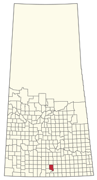
 Location of the RM of Excel No. 71 in Saskatchewan | |
| Coordinates: 49°36′18″N 105°26′38″W / 49.605°N 105.444°W[1] | |
| Country | Canada |
| Province | Saskatchewan |
| Census division | 3 |
| SARM division | 2 |
| Federal riding | Souris—Moose Mountain |
| Provincial riding | Wood River |
| Formed[2] | January 1, 1913 |
| Government | |
| • Reeve | Arnold Montgomery |
| • Governing body | RM of Excel No. 71 Council |
| • Administrator | Jan McDonald |
| • Office location | Viceroy |
| Area (2016)[4] | |
| • Land | 1,122.02 km2 (433.21 sq mi) |
| Population (2016)[4] | |
| • Total | 391 |
| • Density | 0.3/km2 (0.8/sq mi) |
| Time zone | CST |
| • Summer (DST) | CST |
| Postal code | S0H 4H0 |
| Area code(s) | 306 and 639 |
The Rural Municipality of Excel No. 71 (2016 population: 391) is a rural municipality (RM) in the Canadian province of Saskatchewan within Census Division No. 3 and SARM Division No. 2. It is located in the south-central portion of the province.
History
[edit]The RM of Excel No. 71 incorporated as a rural municipality on January 1, 1913.[2]
Geography
[edit]Communities and localities
[edit]The following unincorporated communities are within the RM.
- Localities
- Crane Valley
- Maxwellton
- Readlyn, dissolved as a village, December 31, 1955
- Verwood, dissolved as a village, December 31, 1954
- Viceroy, dissolved as a village, May 10, 2002
Dryboro/ Burn Lake IBA
[edit]Dryboro/ Burn Lake (SK 029) is an Important Bird Area (IBA) of Canada within the RM of Excel.[6] The IBA is located 5 kilometres (3.1 mi) west of Ormiston and covers an area of 25.62 km2 (9.89 sq mi) in the Missouri Coteau region. Dryboro[7] and Burn Lakes[8] are part of a larger complex of connected intermittent salt lakes in a semi-arid landscape surrounded by hilly terrain that is part of a federal Prairie Farm Rehabilitation Administration. The lakes are an important habitat for the endangered piping plover and are protected from development up to the high water mark. Other birds found in the area include the Baird's sparrow, Sprague's pipit, chestnut-collared longspur, clay-coloured sparrow, and the horned lark.[9]
Demographics
[edit]In the 2021 Census of Population conducted by Statistics Canada, the RM of Excel No. 71 had a population of 411 living in 129 of its 169 total private dwellings, a change of 5.1% from its 2016 population of 391. With a land area of 1,093.31 km2 (422.13 sq mi), it had a population density of 0.4/km2 (1.0/sq mi) in 2021.[12]
In the 2016 Census of Population, the RM of Excel No. 71 recorded a population of 391 living in 124 of its 177 total private dwellings, a -8.4% change from its 2011 population of 427. With a land area of 1,122.02 km2 (433.21 sq mi), it had a population density of 0.3/km2 (0.9/sq mi) in 2016.[4]
Government
[edit]The RM of Excel No. 71 is governed by an elected municipal council and an appointed administrator that meets on the first Tuesday of every month.[3] The reeve of the RM is Arnold Montgomery while its administrator is Jan McDonald.[3] The RM's office is located in Viceroy.[3]
Transportation
[edit]The Red Coat & Rail Ltd. operates a short-line railway through the rural municipality. It is primarily used for the transport of agricultural products.[13]
References
[edit]- ^ "Pre-packaged CSV files - CGN, Canada/Province/Territory (cgn_sk_csv_eng.zip)". Government of Canada. July 24, 2019. Retrieved May 23, 2020.
- ^ a b "Rural Municipality Incorporations (Alphabetical)". Saskatchewan Ministry of Municipal Affairs. Archived from the original on April 21, 2011. Retrieved May 9, 2020.
- ^ a b c d "Municipality Details: RM of Excel No. 71". Government of Saskatchewan. Retrieved May 21, 2020.
- ^ a b c "Population and dwelling counts, for Canada, provinces and territories, and census subdivisions (municipalities), 2016 and 2011 censuses – 100% data (Saskatchewan)". Statistics Canada. February 8, 2017. Retrieved May 1, 2020.
- ^ "2019-2020 Rural Revenue Sharing Organized Hamlet Grant". Government of Saskatchewan. Retrieved May 4, 2020.[permanent dead link]
- ^ "Important Bird and Biodiversity Areas". Nature Saskatchewan. Retrieved January 18, 2023.
- ^ "Dryboro Lake". Canadian Geographical Names Database. Government of Canada. Retrieved January 18, 2023.
- ^ "Burn Lake". Canadian Geographical Names Database. Government of Canada. Retrieved January 18, 2023.
- ^ "Dryboro/Burn Lake". IBA Canada. Birds Canada. Retrieved January 18, 2023.
- ^ "Saskatchewan Census Population" (PDF). Saskatchewan Bureau of Statistics. Archived from the original (PDF) on September 24, 2015. Retrieved May 9, 2020.
- ^ "Saskatchewan Census Population". Saskatchewan Bureau of Statistics. Retrieved May 9, 2020.
- ^ "Population and dwelling counts: Canada, provinces and territories, census divisions and census subdivisions (municipalities), Saskatchewan". Statistics Canada. February 9, 2022. Retrieved April 13, 2022.
- ^ Sask Biz

