Fortifications of Vauban UNESCO World Heritage Sites
| UNESCO World Heritage Site | |
|---|---|
 | |
| Location | France |
| Includes | 12 locations in France |
| Criteria | Cultural: (i), (ii), (iv) |
| Reference | 1283 |
| Inscription | 2008 (32nd Session) |
| Area | 1,153.16 ha (2,849.5 acres) |
| Buffer zone | 4,341 ha (10,730 acres) |
| Coordinates | 47°14′10″N 6°1′37″E / 47.23611°N 6.02694°E |

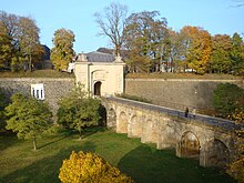
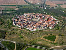
The Fortifications of Vauban UNESCO World Heritage Site is made up of 12 groups of fortified buildings and sites along the borders of France. They were designed by Vauban (1633–1707), and were added in 2008 to the list of UNESCO World Heritage Sites.
List of sites

- Arras, Pas-de-Calais: the Vauban Citadel
- Besançon, Doubs: citadel, city walls and Fort Griffon
- Blaye-Cussac-Fort-Médoc, Gironde: citadel of Blaye, city walls, Fort Paté and Fort Médoc
- Briançon, Hautes-Alpes: city walls, Redoute des Salettes, Fort des Trois-Têtes, Fort du Randouillet, ouvrage de la communication Y and the Asfeld Bridge
- Camaret-sur-Mer, Finistère: Tour dorée (lit. "Gilded Tower") aka. Tour Vauban
- Longwy, Meurthe-et-Moselle: ville neuve
- Mont-Dauphin, Hautes-Alpes: place forte
- Mont-Louis, Pyrénées-Orientales: citadel and city walls
- Neuf-Brisach, Haut-Rhin: ville neuve/Breisach (Germany): gateway of the Rhine
- Saint-Martin-de-Ré, Charente-Maritime: city walls and citadel
- Saint-Vaast-la-Hougue/Tatihou, Manche: watchtowers
- Villefranche-de-Conflent, Pyrénées-Orientales: city walls, Fort Libéria, and Cova Bastera
Two sites initially considered were removed from the final list:
- Bazoches, Nièvre: château
- Belle-Île-en-Mer, Morbihan: citadel and walls surrounding Le Palais
See also
External links
Wikimedia Commons has media related to Fortifications of Vauban.


