
Fujinomiya, Shizuoka
Fujinomiya
富士宮市 | |
|---|---|
 Mount Fuji and Fujinomiya City Office | |
 Flag  Emblem | |
 Location of Fujinomiya in Shizuoka Prefecture | |
 Fujinomiya | |
| Coordinates: 35°13′19.6″N 138°37′17.8″E / 35.222111°N 138.621611°E | |
| Country | Japan |
| Region | Chūbu (Tōkai) |
| Prefecture | Shizuoka |
| Government | |
| • -Mayor | Naoyoshi Komuro |
| Area | |
| • Total | 389.08 km2 (150.22 sq mi) |
| Population (September 2017) | |
| • Total | 132,507 |
| • Density | 340/km2 (880/sq mi) |
| Time zone | UTC+9 (Japan Standard Time) |
| - Tree | Maple |
| - Flower | Fujizakura |
| - Bird | Eurasian skylark |
| - Fish | Rainbow trout |
| Phone number | 0544-22-1119 |
| Address | 150 Yumizawachō, Fujinomiya-shi, Shizuoka-ken 418-8601 |
| Website | Official website |
Fujinomiya (富士宮市, Fujinomiya-shi) is a city located in central Shizuoka Prefecture, Japan. As of 1 July 2019[update], the city had an estimated population of 132,507 in 56,655 households [1],and a population density of 340 persons per km². The total area of the city is 388.99 square kilometres (150.19 sq mi).
Geography
Fujinomiya is located in central Shizuoka Prefecture on an upland plateau on the foothills and lower slopes of Mount Fuji, with an altitude ranging from 35 meters to 3336 meters. The average temperature is 15.6 degrees Celsius. Much of the city lies within the borders of Fuji-Hakone-Izu National Park. Fujinomiya is known as one of the main starting points for climbing trips to Mount Fuji, the summit of which is partly within the borders of the city. As with most of Shizuoka Prefecture, the area enjoys a warm maritime climate with hot, humid summers and mild, cool winters.
Surrounding municipalities
- Shizuoka Prefecture
- Yamanashi Prefecture
Demographics
Per Japanese census data,[2] the population of Fujinomiya has steadily increased over the past 50 years.
| Year | Pop. | ±% |
|---|---|---|
| 1940 | 65,378 | — |
| 1950 | 86,447 | +32.2% |
| 1960 | 88,719 | +2.6% |
| 1970 | 99,021 | +11.6% |
| 1980 | 118,214 | +19.4% |
| 1990 | 127,127 | +7.5% |
| 2000 | 130,372 | +2.6% |
| 2010 | 131,996 | +1.2% |
Climate
The city has a climate characterized by characterized by hot and humid summers, and relatively mild winters (Köppen climate classification Cfa). The average annual temperature in Fujinomiya is 14.9 °C. The average annual rainfall is 1881 mm with September as the wettest month. The temperatures are highest on average in August, at around 26.1 °C, and lowest in January, at around 4.4 °C.[3]
History
Fujinomiya is an ancient settlement, developing as a market town associated with the Ichinomiya, or supreme Shinto shrine of Suruga Province, the Fujisan Hongū Sengen Taisha (富士山本宮浅間大社). Nearby is the sanctuary of Taisekiji temple, founded in 1290 by Nikko Shonin as the headquarters of Nichiren Shoshu Buddhism. Fujinomiya was a post town (fortified during the Sengoku period) on the primary route connecting Suruga with Kai Province. During the Edo period, the area was tenryō territory under direct control of the Tokugawa shogunate. British consul Sir Rutherford Alcock made the first recorded ascent on Mount Fuji by a non-Japanese person from Fujinomiya in 1860. During the cadastral reform of the early Meiji period in 1889, the area was reorganized into Omiya Town and eight villages with Fuji District, Shizuoka.
On 1 June 1942, the modern city was established with the merger of Omiya town with neighboring Fujioka village. The city expanded by annexing neighboring Fujine village in 1955, and Kitayama, Shiraito, Kamiide and Ueno villages in 1956.
From 1987, Aum Shinrikyo had their headquarters in the city.
The most recent merger was on 23 March 2010, when the town of Shibakawa (from Fuji District) was merged into Fujinomiya.
Government
Fujinomiya has a mayor-council form of government with a directly elected mayor and a unicameral city legislature of 22 members.
Economy
Fujinomiya is an industrial center within Shizuoka Prefecture, traditionally with a heavy emphasis on the paper industry. Other manufacturing industries include rotating equipment, chemicals and pharmaceuticals.
Education
Fujinomiya has 21 public elementary schools and 13 public junior high schools operated by the city government. The city has four public high schools operated by the Shizuoka Prefectural Board of Education. The city also has one private junior school, and two private high schools. The prefectural Shizuoka Prefectural Agriculture and Forestry College is also located in Fujinomiya.
Transportation
Railway
 Central Japan Railway Company - Minobu Line
- Gendōji - Fujinomiya - Nishi-Fujinomiya - Numakubo - Shibakawa - Inako
Highway
- Nishi-Fuji Road (connects to Tōmei Expressway)
 National Route 52
 National Route 139
 National Route 469
Bus
- Fuji Kyūkō
- Fuji-Kyū Shizuoka Bus
- Sankō town coach
- Fujinomiya Station - Tokyo International Airport Express Bus
- Fujinomiya Station - Tokyo Station Express Bus
- Kyoto/Osaka line Express Bus
Sister city relations
 Santa Monica, California, United States[4] since July 21, 1975
 Shaoxing, Zhejiang Province, China,[5] since November 11, 1997
Local attractions
- Fujinomiya is famous for yakisoba noodles (富士宮やきそば, Fujinomiya yakisoba)
- Mount Fuji
- Taisekiji Temple
- Fujisan Hongū Sengen Taisha
- Shiraito Falls
- Asagiri Plateau
- Lake Tanuki
- Sengo ruins
- Ōshikakubo ruins
Festivals
- Hatsumōde (Fujisan Hongū Sengen Taisha)
- Yabusame (Horseback archery) Festival (May 4, 5, 6)
- Oyamabiraki (opening of climbing season) July 1
- Gojinka-festival (August)
- Fujinomiya Autumn Festival (November 3, 4, 5)
Events
- The 13th World Scout Jamboree was held August 2–10, 1971 on Asagiri Heights on the western side of Mount Fuji.
- The 9th ISF Women's World Championship was held in Fujinomiya, in 1998.
Noted people from Fujinomiya
- Kumiko Akiyoshi - actress
- Mizuki Sano - singer
- Kōtarō Satomi - actor
- Kaori Shimizu - singer
- Takahiro Yamada (Asian Kung-Fu Generation)
- Masaaki Sawanobori - professional soccer player
- Shinsuke Tayama - Olympic athlete
- Toshie Uematsu - professional wrestler
- Yasuhiro Hiraoka - professional soccer player
- Yutaka Yoshida - professional soccer player
- Hirotsugu Akaike - statistician
Gallery
-
 Fujinomiya City
 -
 Climbing Mount Fuji-Fujinomiya routes
 -
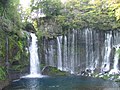 Shiraito Falls
 -
 Lake Tanuki
 -
 Asagiri Plateau
 -
 Otodome Falls
 -
 Wakutama Springs of Mount Fuji
 -
 Fujinomiya yakisoba


References
- ^ Fujinomiya City official statistics Template:Ja
- ^ Fujinomiya population statistics
- ^ Fujinomiya climate data
- ^ "US-Japan Sister Cities by State". Asia Matters for America. Honolulu, HI: East-West Center. Retrieved 20 November 2015.
- ^ "International Exchange". List of Affiliation Partners within Prefectures. Council of Local Authorities for International Relations (CLAIR). Archived from the original on 13 January 2016. Retrieved 21 November 2015.
External links
- Official website
- Official Shizuoka Prefecture homepage
- FUJISAN HONGU SENGENTAISHA official website
- Mount Fuji Fujinomiya Trail Climbing Guide
- Mount Fuji Fujinomiya Trail Climbing Guide
- Fujinomiya info
- Fujinomiya Tourist Association
| Shizuoka |
| |||
|---|---|---|---|---|
| Hamamatsu |
| |||
| Special cities | ||||
| Cities | ||||
| Districts | ||||
| International | |
|---|---|
| National | |
| Geographic | |