
Haram, Norway
Haram Municipality
Haram kommune | |
|---|---|
 | |
 Flag  Coat of arms | |
 Møre og Romsdal within Norway | |
 Haram within Møre og Romsdal | |
| Country | Norway |
| County | Møre og Romsdal |
| District | Sunnmøre |
| Administrative centre | Brattvåg |
| Government | |
| • Mayor (2007) | Bjørn Sandnes (H) |
| Area | |
| • Total | 260.58 km2 (100.61 sq mi) |
| • Land | 253.75 km2 (97.97 sq mi) |
| • Water | 6.83 km2 (2.64 sq mi) |
| • Rank | #295 in Norway |
| Population (2013) | |
| • Total | 9,020 |
| • Rank | #119 in Norway |
| • Density | 35.5/km2 (92/sq mi) |
| • Change (10 years) | |
| Demonym(s) | Harams-mann Harams-kvinne[1] |
| Official language | |
| • Norwegian form | Nynorsk |
| Time zone | UTC+01:00 (CET) |
| • Summer (DST) | UTC+02:00 (CEST) |
| ISO 3166 code | NO-1534[3] |
| Website | Official website |
Haram is a municipality in Møre og Romsdal county, Norway. It is part of the Sunnmøre region. The administrative center is Brattvåg, the industrial center of Sunnmøre. Other important villages in the municipality include Austnes, Eidsvik, Helle, Longva, Hildrestranda, Søvik, Tennfjord, and Vatne.
Brattvåg IL is a sports club based in the municipality. Tennfjord Mannskor is a male choir from the village of Tennfjord. The Ulla Lighthouse and Hellevik Lighthouse are both located in the northwestern part of the municipality.
General information

Haram was established as a municipality on 1 January 1838 (see formannskapsdistrikt). The western island district of Roald was separated from Haram on 1 January 1890 to form a municipality of its own. This left 1,956 people left in Haram. On 1 January 1965, the eastern district of Haram, including the Myklebost area on Harøya island and some smaller islands to the west of there (population: 287), was separated from Haram Municipality and merged into the neighboring Sandøy Municipality to the east. Also on that date most of the municipality of Vatne (population: 2,260) to the southeast of Haram Municipality was merged into Haram Municipality. There was one other municipal boundary change on that date in 1965: the Søvik area in Borgund Municipality (population: 1,191) to the south of Haram Municipality were merged with Haram. This boundary change created a much larger municipality of Haram.[4]
Name
The municipality (originally the parish) is named after the old Haram farm (Old Norse: Harhamarr), since the first church (Haram Church) was built there. The meaning of the first element is unknown and the last element is hamarr which means "rocky hill". Before 1889, the name was written Harham.[5]
Coat of arms
The coat of arms is from modern times. It was granted on 7 August 1987. The arms show three waves in blue with a silver background, symbolizing the importance of the sea in this island municipality.[6]
Dialect
The dialect of the district was well known for its practice of H-dropping and the old and traditional pronunciation of the name of the municipality was [a:ram].
Churches
The Church of Norway has five parishes (sokn) within the municipality of Haram. It is part of the Nordre Sunnmøre deanery in the Diocese of Møre.
| Parish (Sokn) | Church Name | Location of the Church | Year Built |
|---|---|---|---|
| Haram | Haram Church | Austnes | 1838 |
| Lepsøy Chapel | Lepsøya | 1896 | |
| Fjørtoft | Fjørtoft Church | Fjørtofta | 1878 |
| Vatne | Vatne Church | Vatne | 1868 |
| Hamnsund | Hamnsund Church | just south of Søvik | 1875 |
| Brattvåg | Brattvåg Church | Brattvåg | 1977 |
| Hildre Church | Hildrestranda | 1905 |
Geography
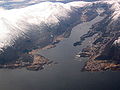
The municipality of Haram includes many islands including Bjørnøya, Fjørtofta, Haramsøya, Løvsøya, Skuløya, and Terøya. The islands of Bjørnøya and Terøya are connected to the mainland via causeways. The islands of Haramsøya and Skuløya are connected with the Ullasund Bridge. The rest of the islands have ferry connections to the mainland. The Haramsfjorden, Vatnefjorden, and Romsdalsfjorden all flow through the municipality.
The municipality shares land borders with Vestnes Municipality to the east and Skodje Municipality to the south. The rest of the municipality is surrounded by sea. The municipality also borders (by sea) Sandøy Municipality and Midsund Municipality to the northeast, Ålesund Municipality to the south, and Giske Municipality to the west.
Media gallery
-
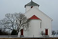 Hildre Church near Brattvåg
 -
 Hamnsund Church near Søvik
 -
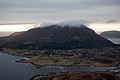
 View of Brattvåg village
 -
 View of Lepsøya island


References
- ^ "Navn på steder og personer: Innbyggjarnamn" (in Norwegian). Språkrådet.
- ^ "Forskrift om målvedtak i kommunar og fylkeskommunar" (in Norwegian). Lovdata.no.
- ^ Bolstad, Erik; Thorsnæs, Geir, eds. (2023-01-26). "Kommunenummer". Store norske leksikon (in Norwegian). Kunnskapsforlaget.
- ^ Jukvam, Dag (1999). "Historisk oversikt over endringer i kommune- og fylkesinndelingen" (PDF) (in Norwegian). Statistisk sentralbyrå.
- ^ Rygh, Oluf (1908). Norske gaardnavne: Romsdals amt (in Norwegian) (13 ed.). Kristiania, Norge: W. C. Fabritius & sønners bogtrikkeri. p. 206.
- ^ "Kommunevåpenet - "Bølgje II"" (in Norwegian). Haram kommune. Retrieved 2010-10-21.
External links
 Møre og Romsdal travel guide from Wikivoyage
Møre og Romsdal county, Norway | |||||||
|---|---|---|---|---|---|---|---|
| |||||||
 | Towns & cities |
| |||||
| Municipalities |
| ||||||
| |||||||