
Mount Kilimanjaro
This article may require copy editing for grammar, style, cohesion, tone, or spelling. (February 2014) |
| Kilimanjaro | |
|---|---|
 Kibo Summit of Kilimanjaro | |
| Highest point | |
| Elevation | 5,895 m (19,341 ft)[1] |
| Prominence | 5,885 m (19,308 ft)[2] Ranked 4th |
| Isolation | 5,510 km (3,420 mi) |
| Listing | |
| Geography | |
 Kilimanjaro Mount Kilimanjaro's location in Tanzania | |
| Location | Kilimanjaro Region, Tanzania |
| Region | TZ-09 |
| Topo map | Kilimanjaro map and guide by Wielochowski[3] |
| Geology | |
| Mountain type | Stratovolcano |
| Last eruption | Between 150,000 and 200,000 thousand years ago |
| Climbing | |
| First ascent | 1889 Hans Meyer Ludwig Purtscheller |
| Easiest route | Hike |


Mount Kilimanjaro, with its three volcanic cones, Kibo, Mawenzi, and Shira, is a dormant volcanic mountain in Tanzania. It is the highest mountain in Africa and the highest free-standing mountain in the world at 5,895 metres or 19,341 feet above sea level (the Uhuru Peak/Kibo Peak).[4]
Geology
Kilimanjaro is composed of three distinct volcanic cones: Kibo, the highest at 5,895 m (19,341 ft); Mawenzi at 5,149 m (16,893 ft); and Shira, the shortest at 3,962 m (13,000 ft). Uhuru Peak is the highest summit on Kibo's crater rim.
Kilimanjaro is a large stratovolcano. Of its three peaks, Mawenzi and Shira are extinct, while Kibo, the highest, is dormant and could erupt again. The last major eruption has been dated to between 150,000 and 200,000 years ago.[5]
Although dormant, Kibo has gas-emitting fumaroles in its crater. Several collapses and landslides have occurred on Kibo in the past, one creating the area known as the Western Breach.
History
Name
The origin of the name "Kilimanjaro" is not precisely known, but a number of theories exist. European explorers had adopted the name by 1860 and reported that "Kilimanjaro" was the mountain's Kiswahili name.[6] But according to the 1907 edition of The Nuttall Encyclopædia, the name of the mountain was "Kilima-Njaro".[7]
Johann Ludwig Krapf wrote in 1860 that Swahilis along the coast called the mountain "Kilimanjaro". Although he did not support his claim,[8] he claimed that "Kilimanjaro" meant either "mountain of greatness" or "mountain of caravans". Under the latter meaning, "Kilima" meant "mountain" and "Jaro" possibly meant "caravans".[6]
Jim Thompson claimed in 1885, although he also did not support his claim,[8]
The term Kilima-Njaro has generally been understood to mean the Mountain (Kilima) of Greatness (Njaro). This is probably as good a derivation as any other, though not improbably it may mean the "White" mountain, as I believe the term "Njaro" has in former times been used to denote whiteness, and though this application of the word is now obsolete on the coast, it is still heard among some of the interior tribes. Either translation is equally applicable.... By the Wa-chaga[,] the mountain is not known under one name, the two masses which form it being respectively named Kibo and Kimawenzi.[9]
According to a website owned by the Jet Propulsion Laboratory, "njaro" is an ancient Kiswahili word for "shining".[10] Similarly, Krapf wrote that a chief of the Wakamba people, whom he visited in 1849, "had been to Jagga and had seen the Kima jaJeu, mountain of whiteness, the name given by the Wakamba to Kilimanjaro...."[11] More correctly in the Kikamba language, this would be Kiima Kyeu, and this possible derivation has been popular with several investigators.[8]
Others have assumed that "Kilima" is Kiswahili for "mountain". The problem with this assumption is that "Kilima" actually means "hill" and is, therefore, the diminutive of "Mlima", the proper Kiswahili word for mountain. However, "[i]t is ... possible ... that an early European visitor, whose knowledge of [Kiswahili] was not extensive, changed mlima to kilima by analogy with the two Chagga names; Kibo and Kimawenzi."[8]
A different approach is to assume that the "Kileman" part of Kilimanjaro comes from the Kichagga "kileme", which means "which defeats", or "kilelema", which means "which has become difficult or impossible". The "Jaro" part would "then be derived from njaare, a bird, or, according to other informants, a leopard, or, possibly from jyaro a caravan."
According to one [Wachagga] informant, the old men tell the story that long ago the Wachagga, having seen the snowy dome, decided to go up to investigate; naturally, they did not get very far. Hence the name: kilemanjaare, or kilemanyaro, or possibly kilelemanjaare etc.- "which defeats," or which is impossible for, the bird, the leopard, or the caravan. This is attractive as being entirely made up of [Wachagga] elements based on an imaginable situation, but the fact remains that the name Kilimanjaro is not, and apparently never has been, current among the Wachagga as the name of the mountain. Is this then only, as other Wachagga suggest, a latter-day attempt to find a [Wachagga] explanation when pressed to do so by a foreign enquirer? Is it perhaps arguable that the early porters from the coast hearing the Wachagga say kilemanjaare or kilemajyaro, meaning simply that it was impossible to climb the mountain, imagined this to be the name of the mountain, and associated it with their own kilima? Did they then report to the European leaders of the expedition that the name of the mountain was, their version of the Kichagga, which, further assimilated by the European hearer, finally became standardised as Kilimanjaro?[8]
In the 1880s, the mountain became a part of German East Africa and was called "Kilima-Ndscharo" in German following the Kiswahili name components.[12]
On 6 October 1889, Hans Meyer reached the highest summit on the crater ridge of Kibo. He named it "Kaiser-Wilhelm-Spitze" ("Kaiser Wilhelm peak").[13] That name apparently was used until Tanzania was formed in 1964,[14] when the summit was renamed "Uhuru", meaning "Freedom Peak" in Kiswahili.[15] The Kaiser Wilhelm-Spitze, with its altitude of 5895 meters (19,340 ft.) was known at that time as the highest mountain of the German Empire.

Climbing history

According to the famous English geographer Halford Mackinder: "It was the missionary Rebmann of Mombasa who, in 1848, first reported the existence of Kilimanjaro."[16] In 1861, the German officer Baron Carl Claus von der Decken and the young British geologist Richard Thornton (1838–1863) made a first attempt to climb Kibo,[17] but "got no farther than 8,200 feet"[18] (2,500 meters). In 1862, Von der Decken tried a second time together with Otto Kersten. They reached a height of 14,000 feet (4,280 meters).[19][20]
In 1887, during his first attempt to climb Kilimanjaro, the German geology professor Hans Meyer reached the base of Kibo, but was forced to turn back, not having the equipment necessary to handle the deep snow and ice on Kibo. The following year, Meyer planned another attempt with cartographer Oscar Baumann, but the mission was aborted due to consequences of the Abushiri Revolt. Meyer and Baumann were captured and held hostage, and only escaped after a ten thousand rupees ransom had been paid.[21]
In 1889 Meyer returned to Kilimanjaro with the celebrated Austrian mountaineer Ludwig Purtscheller for a third attempt. Their climbing team included two local headmen, nine porters, a cook, and a guide. The success of this attempt, which started on foot from Mombasa, was based on the establishment of many campsites with food supplies so that multiple attempts at the top could be made without having to descend too far. Meyer and Purtscheller pushed to near the crater rim on October 3, but turned around exhausted from hacking footsteps in the icy slope. Three days later they reached the highest summit on the southern rim of the crater on Purtscheller's 40th birthday (October 6, 1889). They were the first to confirm that Kibo has a crater, which was filled with ice at the time. After descending to the saddle between Kibo and Mawenzi, Meyer and Purtscheller attempted to climb the more technically challenging Mawenzi next, but could only reach a 5096 m high subsidiary peak (later to be named Klute Peak) before retreating due to illness. On October 18, they reascended Kibo to enter and study the crater, cresting the rim at Hans Meyers Notch. In total, Meyer and Purtscheller spent 16 days above 4,200 m during their expedition.[21][22]
The summit of Kibo wouldn't be climbed again until 20 years later by the surveyor M. Lange in 1909. The first ascent of the highest summit of Mawenzi was only on July 29, 1912, by the German climbers Edward Oehler and Fritz Klute, who christened it Hans Meyer Peak in Meyer's honor. Oehler and Klute went on to make the third ascent of Kibo, via the Western route over the Drygalski Glacier.[22]
In 1989, the organizing committee of the 100-year celebration of the first ascent decided to award posthumous certificates to the African porter-guides who had accompanied Meyer and Purtscheller. One person in pictures or documents of the 1889 expedition was thought to match a living inhabitant of Marangu, Yohani Kinyala Lauwo. Lauwo did not know his own age nor did he remember Meyer or Purtscheller, but he remembered joining a Kilimanjaro expedition involving a Dutch doctor who lived near the mountain and that he did not get to wear shoes during the 8-day affair. Lauwo claimed that he had climbed the mountain 3 times before World War I. The committee concluded that he had been a member of Meyer's team and therefore must have been born around 1871.[23] Lauwo died on 10 May 1996 and is now often suggested as co-first-ascendant of Kilimanjaro.[24]
Mapping
Early maps of Kilimanjaro were published by the British Government's Directorate of Overseas Surveys (DOS 422 Y742) in 1963. These were based on air photography carried out as early as 1959 by the RAF. These were on a scale of 1:50,000 with contours at 100 ft intervals. These are now unavailable. Tourist mapping was first published by the Ordnance Survey in England in 1989 based on the original DOS mapping (1:100,000, 100 ft intervals, DOS 522). This is also no longer available. EWP produced a map with tourist information in 1990 (1:75,000, 100 m contour intervals, inset maps of Kibo and Mawenzi on 1:20,000 and 1:30,000 scales respectively and 50 m contour interval). In the last few years, numerous other maps have become available of various qualities.[3] 3D route maps are also available online.[25]
Trekking Kilimanjaro
There are seven official trekking routes by which to ascend and descend Mount Kilimanjaro: Lemosho, Machame, Marangu, Mweka, Rongai, Shira, and Umbwe.[26] Of all the routes, Machame is considered the most scenic, albeit steeper, route.[27] It can be done in six or seven days.[27] The Rongai is the easiest and least scenic of all camping routes.[28] The Marangu is also relatively easy, but this route tends to be very busy, the ascent and descent routes are the same, and accommodation is in shared huts with all other climbers.[29]
People who wish to trek to the summit of Kilimanjaro are advised to undertake appropriate research[30] and ensure that they are both properly equipped and physically capable. Though the climb is technically not as challenging as when climbing the high peaks of the Himalayas or Andes, the high elevation, low temperature, and occasional high winds make this a difficult and dangerous trek. Acclimatisation is essential, and even the most experienced trekkers suffer some degree of altitude sickness.[31] Kilimanjaro summit is well above the altitude at which high altitude pulmonary edema or high altitude cerebral edema can occur.[32] All trekkers will suffer considerable discomfort, typically shortage of breath, hypothermia, and headaches.
High-altitude climbing clubs—citing safe ascent rate suggestions offered by organisations such as the Royal Geographical Society—have criticized the Tanzanian authorities for charging fees for each day spent on the mountain. It was once argued that this fee structure encouraged trekkers to climb rapidly to save time and money, while proper acclimatization demands that delays are built into any high climb. However, in response to this accusation, the Tanzania National Parks Authority several years ago mandated minimum climb durations for each route. These regulations prohibit climbs of fewer than five days on the Marangu Route, and ensure a minimum of six days for the other five sanctioned routes. These minimums — particularly in the case of Marangu, which ostensibly allows that Uhuru Peak can be reached from a starting elevation at 1,860m within 72 hours of beginning the ascent — are reckoned by most alpinists to allow an ascent rate that will usually result in the climber failing to acclimatize adequately, by the time that Kibo Huts are reached; the launch base from which the summit is assaulted. Consequently, the incidence of Acute Mountain Sickness (AMS) is widely deemed to be unacceptably high on Kilimanjaro, with high volumes of fit young people succumbing to the condition, having opted for a relatively rapid ascent. As a general rule, it is far safer (and more enjoyable) to avoid altitude sickness by planning a sensible itinerary that allows for gradual acclimatisation to high elevation as one ascends. Operations that typically see in excess of a thousand climbers summitting annually and are best placed to identify such patterns, usually posit that an optimal climb length should last around seven to eight days.
Tanzanian Medical Services around the mountain have expressed concern recently[when?] over the current influx of tourists that apparently perceive Kilimanjaro as an easy walk. However this is not the case. Many individuals require significant attention during their attempts, and many are forced to abandon the trek. An investigation into the matter concluded that tourists visiting Tanzania were often encouraged to join groups heading up the mountain without being made aware of the significant physical demands of the climb, although many outfitters and tour operators flaunt high success rates for reaching the summit. The Kilimanjaro National Park shows that only 41% of trekkers actually reach the Uhuru summit with the majority turning around at Gilman’s Point, 300 metres (980 feet) short of Uhuru, or Stella Point, 200 (660 feet) meters short of Uhuru. Kilimanjaro is often underestimated because it can be walked and is not a technical climb. However, many mountaineers consider Kilimanjaro very physically demanding.[citation needed]
Some estimate that more people have died to date trekking up Kilimanjaro than Mount Everest but Everest is attempted by significantly fewer climbers.[citation needed] In August 2007 four trekkers died within a week underscoring the point that trekking to the summit should not be taken casually. Multiple people (such as trekkers, porters, and guides) die on the mountain each year. The majority of these deaths are porters due to hypothermia. Trekkers fall on steep portions of the mountain, and rock slides have killed trekkers. For this reason, the route via the Arrow Glacier was closed for several years. It re-opened in December 2007,[33] but the park officials advise against taking that route and tell trekkers that they can climb, but at their own risk. When attempting the Arrow Glacier route, trekkers must leave early in the morning and make it past the rock face before mid-afternoon as when the sun comes out, unfrozen rock slides become quite common.
-
 Caution signs at the Machamé trailhead
 -
 Sign at Uhuru peak, indicating to trekkers that they have reached the top
 -
 Memorial recognizing Hans Meyer as the first European to "conquer" Kilimanjaro


Unique vegetation
Being an Afromontane sky island, Kilimanjaro has an enormous biodiversity while low in endemic species. However endemics include the giant groundsels in the bunchgrass tussock grasslands, and other flora adapted to living in alpine plant conditions.
Kilimanjaro has a large variety of forest types over an altitudinal range of 3,000 m (9,843 ft) containing over 1,200 vascular plant species. Montane Ocotea forests occur on the wet southern slope. Cassipourea and Juniperus forests grow on the dry northern slope. Subalpine Erica forests at 4,100 m (13,451 ft) represent the highest elevation cloud forests in Africa. In contrast to this enormous biodiversity, the degree of endemism is low. However, forest relicts in the deepest valleys of the cultivated lower areas suggest that a rich forest flora inhabited Mt Kilimanjaro in the past, with restricted-range species otherwise only known from the Eastern Arc mountains. The low degree of endemism on Kilimanjaro may result from destruction of lower elevation forest rather than the relatively young age of the mountain.
Another feature of the forests of Kilimanjaro is the absence of a bamboo zone, which occurs on all other tall mountains in East Africa with a similarly high rainfall. Sinarundinaria alpina stands are favoured by elephants and African buffalos elsewhere. On Kilimanjaro these megaherbivores occur on the northern slopes, where it is too dry for a large bamboo zone to develop. They are excluded from the wet southern slope forests by topography and humans, who have cultivated the foothills for at least 2000 years.
This interplay of biotic and abiotic factors could explain not only the lack of a bamboo zone on Kilimanjaro but also offers possible explanations for the patterns of diversity and endemism. If true, Kilimanjaro's forests would serve as a striking example of the large and long-lasting influence of both animals and humans on the African landscape.
Physical features

Kilimanjaro rises approximately 5,100 m (16,732 ft) from its base in the plains near Moshi. Kibo is capped by an almost symmetrical cone with scarps rising 180 to 200 m on the south side. These scarps define a 2.5 km wide caldera.[34] Within this caldera is an inner crater, the Reusch Crater. This inner crater was named after Dr. Richard Reusch. The name was conferred by the government of Tanganyika in 1954 at the same time it awarded Reusch a gold medal on having climbed Kilmanjaro for the 25th time. Reusch climbed Kilimanjaro 65 times and helped to establish the exact elevation of the crater.[35][36] Within the Reusche Crater lies the Ash Pit. The Reusche Crater itself is nearly surrounded by a 400 feet (120 m) high dune of volcanic ash.[37]
-
 The decrease in snow/ice cover on the summit from 1993 (top) to 2000 (bottom)
 -
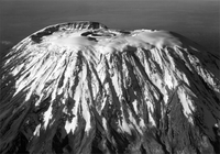 Aerial view of the Kibo summit of Mount Kilimanjaro


Ice
In the late 1880s, the summit of Kibo was completely covered by an ice cap with outlet glaciers cascading down the western and southern slopes, and except for the inner cone, the entire caldera was buried. Glacier ice flowed also through the Western Breach.[34]
An examination of ice cores taken from the North Ice Field Glacier indicates that the "snows of Kilimanjaro" (aka glaciers) have a basal age of 11,700 years.[38][39] A continuous ice cap covering approximately 400 square kilometers (150 sq mi) covered the mountain during the period of maximum glaciation, extending across the summits of Kibo and Mawenzi.[34] The glacial ice survived drought conditions during a three century period beginning ~2200 BC.[40]
The period from 1912 to present has witnessed the disappearance of more than 80% of the ice cover on Kilimanjaro. From 1912 to 1953 there was ~1% annual loss, while 1989–2007 saw ~2.5% annual loss. Of the ice cover still present in 2000, 26% had disappeared by 2007. While the current shrinking and thinning of Kilimanjaro's ice fields appears to be unique within its almost twelve millennium history, it is contemporaneous with widespread glacier retreat in mid-to-low latitudes across the globe. At the current rate, Kilimanjaro is expected to become ice-free some time between 2022 and 2033.[40]
See also
- Furtwängler Glacier
- List of volcanoes in Tanzania
- Mount Kenya, a collapsed stratovolcano 200 miles (322 km) due north, in Kenya.
- Rebmann Glacier
- "The Snows of Kilimanjaro"
References
- ^ "Kilimajaro Guide—Kilimanjaro 2010 Precise Height Measurement Expedition". Retrieved 16 May 2009.
- ^ "Kilimanjaro". Peakbagger.com. Retrieved 2012-08-16.
- ^ a b Kilimanjaro Map and tourist Guide (Map) (4th ed.). 1:75,000 with 1:20,000 and 1:30,000 insets. EWP Map Guides. Cartography by EWP. EWP. 2009. ISBN 0-906227-66-6.
- ^ the Kilimanjaro 2008 Precise Height Measurement Expedition. "Precise Determination of the Orthometric Height of Mt. Kilimanjaro" (PDF). Retrieved May 12, 2009.
{{cite web}}: CS1 maint: numeric names: authors list (link) - ^ Nonnotte, Philippe; Hervé Guillou; Bernard Le Gall; Mathieu Benoit; Joseph Cotten; Stéphane Scaillet (2008). "New K-Ar age determinations of Kilimanjaro volcano in the North Tanzanian diverging rift, East Africa" (PDF). Journal of Volcanology and Geothermal Research. 173 (1–2): 99–112. doi:10.1016/j.jvolgeores.2007.12.042.
- ^ a b Travels, researches, and missionary labours, during an eighteen years' residence in Eastern Africa: Together with journeys to Jagga, Usambara, Ukambani, Shoa, Abessinia and Khartum; and a coasting voyage from Mombaz to Cape Delgado, authored by Johann Ludwig Krapf and Ernest George Ravenstein, Trübner and Company, 1860, page 255
- ^ The Nuttall Encyclopædia, 1907, FromOldBooks.com, 2006
- ^ a b c d e Hutchinson, J. A. (1965). "The Meaning of Kilimanjaro". Department of Language and Liguistics. Dar Es Salaam: University College.
- ^ Through Masai land: a journey of exploration among the snowclad volcanic mountains and strange tribes of eastern equatorial Africa, authored by Johann Ludwig Krapf and Ernest George Ravenstein, Low, Marston, Searle, & Rivington, London, 1887
- ^ NASA-Tanzania "SRTM TANZANIA IMAGES", Jet Propulsion Laboratory, California Institute of Technology, 28 August 2005
- ^ Travels, researches, and missionary labors, during an eighteen years' residence in Eastern Africa: Together with journeys to Jagga, Usambara, Ukambani, Shoa, Abessinia and Khartum; and a coasting voyage from Mombaz to Cape Delgado, authored by Johann Ludwig Krapf and Ernest George Ravenstein, Trübner and Company, 1860, page 544
- ^ Briggs, Philip (1996): "Guide to Tanzania; 2nd edition." Bradt Guides.
- ^ "German Contributions to the Cartography of South West and East Africa from Mid 19th Century to World War I", Proceedings of the 21st International Cartographic Conference, Durban, South Africa, authored by I. J. Demhardt, Department of Geography, University of Technology Darmstadt, page 903, 2003
- ^ Refer, for example, to "Further Notes on the Kibo Inner Crater and Glaciers of Kilimanjaro and Mount Kenya", authored by P. C. Spink, The Geographical Journal, vol. 106, no. 5/6, November - December 1945, page 213
- ^ "Dangar Alpine Notes", The Alpine Journal, authored by D. F. O. Dangar, volume 70, numbers 310 and 311, 1965, page 328
- ^ Mackinder, Halford (1900). "A Journey to the Summit of Mount Kenya, British East Africa". The Geographical Journal. 15 (5): 453–476. JSTOR 1774261.
- ^ Gary Firth: in Target 1992 Portrait des Geologen Richard Thornton
- ^ Dundas, Charles. "Kilimanjaro and its People" 1924, Cass London, nTZ.info, accessed February 21, 2011.
- ^ Carl Claus von der Decken, bearbeitet von Otto Kersten: Reisen in Ost-Afrika in den Jahren 1859 bis 1865, Erzählender Teil 1871, Band 2 S. 52
- ^ Bernard Verdcourt: Collectors in East Africa – 31. Baron Carl Claus von der Decken 1833–1865 Text extracted from The Conchologists’ Newsletter, No.162, pp. 204–211 published September 2002
- ^ a b History of Kilimanjaro: The conquest of Kilimanjaro
- ^ a b Alexander Stewart, Kilimanjaro. A complete trekker's guide., Cicerone Publishers, 2004-2011, pp. 81-85
- ^ Meyer and Purtschell were not alone, Tanzanian Affairs, January 1, 1990
- ^ The Old Man of Mt. Kilimanjaro
- ^ 3D Maps
- ^ "Mt. Kilimanjaro Routes: The Advantages and Disadvantage of All Mount Kilimanjaro Climbing Routes", Mount Kilimanjaro Guide
- ^ a b "Climbing Mount Kilimanjaro on the Machame Route", Mount Kilimanjaro Guide
- ^ "Climbing Mount Kilimanjaro on the Rongai Route", Mount Kilimanjaro Guide
- ^ "Marangu Route", Kilimanjaro Routes
- ^ R. Stoppelenburg. "Prepare yourself for the Kilimanjaro climb".
- ^ Muza, SR; Fulco, CS; Cymerman, A (2004). "Altitude Acclimatization Guide". US Army Research Inst. of Environmental Medicine Thermal and Mountain Medicine Division Technical Report (USARIEM-TN-04-05). Retrieved 2009-03-05.
{{cite journal}}: CS1 maint: multiple names: authors list (link) - ^ Cymerman, A; Rock, PB. "Medical Problems in High Mountain Environments. A Handbook for Medical Officers". USARIEM-TN94-2. US Army Research Inst. of Environmental Medicine Thermal and Mountain Medicine Division Technical Report. Retrieved 2009-03-05.
{{cite journal}}: Cite journal requires|journal=(help)CS1 maint: multiple names: authors list (link) - ^ "Lava Tower en route to Barranco Camp". Africa Travel. About.com. Retrieved March 23, 2011.
{{cite web}}: Italic or bold markup not allowed in:|publisher=(help) - ^ a b c Young, James A.T. "Glaciers of the Middle East and Africa" (PDF). U.S. Geological Professional Survey. U.S. Department of the Interior. pp. G61, G58, G59 G62. Retrieved 16 August 2012.
- ^ http://www.richardreusch.com/testimonials.php
- ^ The Power of Purpose: Find Meaning, Live Longer. Richard J Leider. page 13.
- ^ On Thin Ice. Mark Bowen. 2005. ISBN 0-8050-6443-5. page 342. Explore Mount Kilmanjaro. fold out map.
- ^ On Thin Ice. Mark Bowen. 2005. ISBN 0-8050-6443-5. page 380.
- ^ Thompson, Lonnie G. "Kilimanjaro Ice Core Records: Evidence of Holocene Climate Change in Tropical Africa" (PDF). Science Magazine. Retrieved 16 August 2012.
- ^ a b Thompson LG, Brecher HH, Mosley-Thompson E, Hardy DR, Mark BG (2009). "Glacier loss on Kilimanjaro continues unabated". Proceedings of the National Academy of Sciences. 106 (47): 19770–5. doi:10.1073/pnas.0906029106.
{{cite journal}}: CS1 maint: multiple names: authors list (link)
Further reading
- Dundas, Sir Charles (1924) Kilimanjaro and Its People: A History of the Wachagga, Their Laws, Customs and Legends, Together with Some Account of the Highest Mountain in Africa 1st Edition London: Cass.
- Ernest Hemingway, "The Snows of Kilimanjaro".
- Freeman, Sue C. 'In My Wildest Dreams, A Woman's Humorous Perspective Of Her Mt. Kilimanjaro Experience'
External links
- Mount Kilimanjaro National Park
- NASA Earth Explorer page
- Glacial recession of Southern Icefields
- Mt Kilimanjaro live webcam
- Kilimanjaro Flora Picture Gallery
- Aerial photographs of Mount Kilimanjaro, 1937-38—University of Wisconsin-Milwaukee Libraries Digital Collections
- Kilimanjaro
- How hard is it to climb Mount Kilimanjaro?