Lira, Uganda
Lira | |
|---|---|
 | |
| Country | |
| Region | Northern Uganda |
| Sub-region | Lango sub-region |
| District | Lira District |
| Government | |
| • Mayor | Morish Odung[1] |
| Elevation | 3,540 ft (1,080 m) |
| Population (2011 Estimate) | |
| • Total | 108,600 |
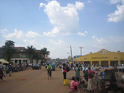
Lira is a city in Northern Uganda. It is the main municipal, administrative and commercial centre of Lira District. Lira was the main metropolitan center of the now defunct Lango District (which corresponds geographically with the current Lango sub-region).
Location
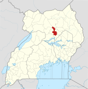
Lira is located approximately 110km by road, southeast of the city of Gulu, the largest city in Northern Uganda, along the highway between Gulu and Mbale.[2] This location lies approximately 270 kilometres (170 mi), by road, north of Kampala, the capital of Uganda and the largest city in that country.[3] The coordinates of Lira are:2°14'50.0"N 32°54'00.0"E (Latitude:02.247223; Longitude:32.900000).[4]
Lango sub-region
Lira lies in Lira District. Lira District is part of Lango sub-region, which consists of the following districts: (a) Alebtong District (b) Amolatar District (c) Apac District (d) Dokolo District (e) Lira District (f) Kole District (g) Otuke District and (h) Oyam District. The city of Lira remains the principle commercial centre of the sub-region.
Population
The 2002 national census estimated the population of Lira at about 80,900. In 2010, the Uganda Bureau of Statistics (UBOS), estimated the population of Lira at approximately 105,100. In 2011, UBOS estimated the mid-year population of Lira at 108,600.[5]

Transport
Lira is served by a railway station of the Uganda Railways network.[6] The town is also served by a public, civilian airport, Lira Airport, administered by the Uganda Civil Aviation Authority.
Religion
Lira is the seat of the Roman Catholic Diocese of Lira, headed by a Catholic Bishop; The Right Reverend Joseph Franzelli.
Points of interest
The following points of interest lie within the town limits or close to the edges of town:
- The headquarters of Lira District Administration
- The offices of Lira Town Council
- Lira Central Market
- The Lira Campus of Uganda Martyrs University, a private university, whose main campus is located in Nkozi, Mpigi District.
- Lira Airport - Administered by the Civil Aviation Authority of Uganda
- The headquarters of the Roman Catholic Diocese of Lira
- All Saints University - A private university affiliated with the Church of Uganda.
- Lira Hotel, Open since 1970's till date, over looks the Lira Gols Course and Air Strip
Other points of interest
Other points of interest in Lira or near the town, include the following:
- A branch of Bank of Africa
- A branch of BOBU
- A branch of Bayport Financial Services limited
- A branch of Barclays Bank
- A branch of Centenary Bank
- A branch of Crane Bank
- A branch of DFCU Bank
- A branch of Kenya Commercial Bank
- A branch of PostBank Uganda
- A branch of Stanbic Bank
- A branch of Pride Microfinance Limited
- A branch of Housing Finance Bank
- A branch of the National Social Security
- A branch of Virah Forex Bureau (Uganda)
See also
References
- ^ Birungi, Machrine (5 March 2011). "Incumbent Lira Mayor Seeks Court Order for Vote Recount". Uganda Radio Network. Retrieved 3 June 2014.
- ^ "Road Distance Between Gulu And Lira With Map". Globefeed.com. Retrieved 3 June 2014.
- ^ "Map Showing Lira And Kampala With Distance Marker". Globefeed.com. Retrieved 3 June 2014.
- ^ Google, . "Location of Lira At Google Maps". Google Maps. Retrieved 3 June 2014.
{{cite web}}:|first=has numeric name (help);|last=has generic name (help) - ^ UBOS, . "Estimated Population of Lira In 2002, 2010 And 2011" (PDF). Uganda Bureau of Statistics (UBOS). Retrieved 3 June 2014.
{{cite web}}:|first=has numeric name (help) - ^ Cissy Makumbi, Cissy (28 October 2013). "Museveni Opens Gulu Railway Line". Daily Monitor. Retrieved 3 June 2014.

