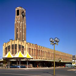
Atwater Market
| Atwater Market | |
|---|---|
 | |
 | |
| General information | |
| Architectural style | Art deco |
| Location | Atwater Street, Montreal |
| Opened | 1933 |
| Design and construction | |
| Architect(s) | Ludger Lemieux |
| Other information | |
| Public transit access | |
Atwater Market is a market hall located in the Saint-Henri area of Montreal, Quebec, Canada. It opened in 1933. The interior market is home to many butchers and the Première Moisson bakery and restaurant. The outside market has many farmers' stalls, which sell both local and imported produce, as well as two cheese stores, a wine store and a fish store.
The market's Art Deco building was designed by architect Ludger Lemieux, working with his son, Paul Lemieux.[1] It is located on Atwater Street, near the Lachine Canal, as well as Greene Avenue. A pedestrian bridge, which can also be used by bicycles, connects the market to Saint-Patrick Street and to a bicycle path in Pointe-Saint-Charles on the other side of the Lachine Canal. The presence of this bridge explains the popularity of this market with bike riders, who often stop there, and contributes to the summer ambiance of the area. The bike path travels from the Old Port of Montreal to the Lachine Marina and is owned and maintained by Parks Canada.
The area immediately east and west of the market has experienced gentrification, with a number of upscale condominiums being built right on the Lachine Canal, causing rent prices in the area to increase rapidly. Since the Lachine Canal reopened in 2002, residential property values in the Southwest borough have shot up by 61%, according to Montreal's 2006 property valuation roll, with the highest growth happening around the Atwater Market.
Origin of the name
[edit]Atwater Market takes its name from the adjacent Atwater Street, which was named in 1871 after Edwin Atwater (1808–1874), a municipal alderman of the district of Saint-Antoine.
Gallery
[edit]-
Atwater Market's tower
See also
[edit]References
[edit]- ^ "Montreal Insites". Heritage Montreal. Retrieved 2009-11-15.
External links
[edit] Media related to Atwater Market at Wikimedia Commons
- Marchés publics de Montréal, the agency that runs the Marché Atwater


