Maucomble
Appearance
From Wikipedia, the free encyclopedia
This is an old revision of this page, as edited by EP111 (talk | contribs) at 19:22, 21 May 2018 (ibx img). The present address (URL) is a permanent link to this revision, which may differ significantly from the current revision.
Commune in Normandy, France
Maucomble | |
|---|---|
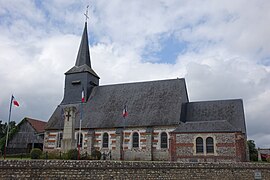
 The church in Maucomble | |
| Coordinates: 49°40′58″N 1°20′03″E / 49.6828°N 1.3342°E / 49.6828; 1.3342 | |
| Country | France |
| Region | Normandy |
| Department | Seine-Maritime |
| Arrondissement | Dieppe |
| Canton | Neufchâtel-en-Bray |
| Intercommunality | CC Bray-Eawy |
| Government | |
| • Mayor | Guy Maruitte |
| Area 1 | 5.07 km2 (1.96 sq mi) |
| Population (2006) | 331 |
| • Density | 65/km2 (170/sq mi) |
| Time zone | UTC+01:00 (CET) |
| • Summer (DST) | UTC+02:00 (CEST) |
| INSEE/Postal code | 76417 /76680 |
| Elevation | 149–235 m (489–771 ft) (avg. 200 m or 660 ft) |
| 1 French Land Register data, which excludes lakes, ponds, glaciers > 1 km2 (0.386 sq mi or 247 acres) and river estuaries. | |
Maucomble is a commune in the Seine-Maritime department in the Normandy region in northern France.
Geography
A farming and forestry village situated in the Pays de Bray, some 31 miles (50 km) southeast of Dieppe at the junction of the D118 and the D929 roads. The A28 autoroute passes through the territory of the commune.
Population
| 1962 | 1968 | 1975 | 1982 | 1990 | 1999 | 2006 |
|---|---|---|---|---|---|---|
| 301 | 303 | 315 | 278 | 318 | 321 | 331 |
| Starting in 1962: Population without duplicates | ||||||
Places of interest
- The church of St.Ouen, dating from the thirteenth century.
See also
References
External links
Wikimedia Commons has media related to Maucomble.
Retrieved from "https://en.wikipedia.org/w/index.php?title=Maucomble&oldid=842331599"
Hidden categories:
- Pages using gadget WikiMiniAtlas
- Articles with short description
- Short description is different from Wikidata
- Coordinates on Wikidata
- Pages using infobox settlement with image map1 but not image map
- France articles requiring maintenance
- Commons category link from Wikidata
- All stub articles
- Pages using the Kartographer extension


