
Maumturks
| Maumturks | |
|---|---|
| Template:Lang-ga | |
 Maumturk Mountains, County Galway | |
| Highest point | |
| Peak | Barrslievenaroy |
| Elevation | 702 m (2,303 ft) |
| Geography | |
 | |
| Country | Republic of Ireland |
| Provinces of Ireland | Connacht |
Sléibhte Mhám Toirc (The Maumturks/Maamturks, the Turks (fam.)) are a picturesque mountain range in Connemara in the west of Ireland. They are less well known than their more famous neighbours, the Twelve Bens on the other side of the Inagh Valley (and of the Western Way long distance path). They are not very big (max 702m) but a pleasant climb in fine weather, with superb views and no congestion. Dedicated fell runners run from Maumeen in the south to Leenaun in the north in a single day.
Highest points
The table below lists some of the highest major mountain peaks of the Maumturk Mountains.
| Rank | Mountain peak | Elevation | English Name |
|---|---|---|---|
| 1 | Binn Idir an Dá Log | 702 m (2,303 ft) | Barrslievenaroy |
| 2 | Leitir Bhriocáin | 667 m (2,188 ft) | Letterbreckaun |
| 3 | Binn Mhór | 661 m (2,169 ft) | BinnMhor |
| 4 | Binn Chaonaigh | 633 m (2,077 ft) | Binn Chaonaigh |
Images
-
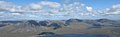 The Maumturk Mountains looking across the Inagh Valley from Ben Corr
 -
 Peat-cutting near Loch an Imligh

External links
- Mountaineering Ireland
- An Óige / Irish Youth Hostels Assoc. page for County Galway See especially Ben Lettery - Binn Leitri.
Suggested reading
"The Mountains of Connemara : a hill walker's guide" (ISBN 0-9504002-4-6) - includes a more useful 1:50000 map than the OS maps 37, 38, 44.
This article related to the geography of County Galway, Ireland is a stub. You can help Wikipedia by expanding it. |
53°29′N 9°36′W / 53.48°N 9.60°W
Mountains and hills of Connacht | |||||||
|---|---|---|---|---|---|---|---|
| Achill Island |  | ||||||
| Dartry Mountains | |||||||
| Maumturks | |||||||
| Mweelrea Mountains | |||||||
| Nephin Range | |||||||
| Ox Mountains | |||||||
| Partry Mountains | |||||||
| Sheeffry Range | |||||||
| Benna Beola |
| ||||||
| Others | |||||||