
Museum of Aviation (Warner Robins)
 2006 aerial photo of museum buildings and aircraft | |
 | |
| Established | 1981 |
|---|---|
| Location | Robins Air Force Base, Georgia |
| Type | Aerospace |
| Owner | United States Air Force |
| Website | http://www.museumofaviation.org/ |
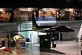
The Museum of Aviation is the second-largest aerospace museum of the United States Air Force. The museum is located just outside Warner Robins, Georgia, and near Robins Air Force Base. It has a total of five different buildings containing fewer than its previous 93 different aircraft on 51 acres (21 ha). The museum is also the home of the Georgia Aviation Hall of Fame.[1]
Aircraft on display
Bombers
|
Cargo aircraft
|
Fighters
|
|
Helicopters
|
|
Missiles and drones
|
Trainers
|
|
Special aircraft
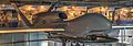
The SR-71A Blackbird on display is the current record holder for flight airspeed. Serial number 61-7958 set an absolute speed record of 1,905.81 knots (2,193.2 mph; 3,529.6 km/h) on July 28, 1976, which stands today.[2]
|
Gallery
-
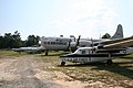
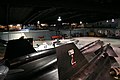
 Airplanes in rear of museum
 -
 Airplanes in rear of museum
 -
 Airplanes in rear of museum


Bombers
-
 B1 Bomber at entrance to the museum
 -


Cargo aircraft


Fighters
-
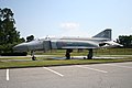 F4 Phantom II at entrance to the museum
 -
 F15 Eagle inside main entrance
 -
 Curtiss P40N
 -

-
 Republic F-105D
 -


P-51
-
 North American P51D Mustang
 -


F-111


Helicopters


Trainers
-

-

-
-
 Cessna T-37B "Tweety Bird"


Special aircraft
-
 Lockheed U-2 in hangar (#66682)
 -
 Rockwell OV-10 Bronco
 -

-
 RQ-4A "Global Hawk"
 -
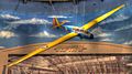 Laister-Kauffman TG-4A
 -
 Stinson L-5E Sentinel


SR-71
-
 SR-71A Blackbird in hangar (#61 7958)
 -
 SR-71A Blackbird in hangar
 -
 detail of SR-71 Blackbird


Other Air Force museums
- See: National Museum of the United States Air Force and National Museum of the USAF #Other Air Force museums
References
- ^ Head, William; Iobst, Richard W. (Summer 1992). "Preserving the History of Air Power Logistics in the Southeast: The First Decade of the Museum of Aviation at Robins AFВ, Georgia" (PDF). Air Force Journal of Logistics: 25–29.
{{cite journal}}: Invalid|ref=harv(help) - ^ A-12, YF-12A, & SR-71 Timeline of Events
External links
Wikimedia Commons has media related to Museum of Aviation (Warner Robins).