Nabawan
Appearance
Nabawan | |
|---|---|
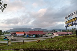
 Nabawan town. | |
 | |
| Country | |
| State | |
| Division | Interior |
| Population (2010) | |
• Total | 31,807 |
| Website | www.sabah.gov.my/pd.nbw |
Nabawan is a town located in Interior Division of Sabah, east Malaysia on the island of Borneo. Its population was estimated to be around 31,807 in 2010,[1] and is almost entirely ethnic Murut and a minority ethnic such as Lun Bawang/Lun Dayeh. Nabawan covers an area of 6089km². Situated in the southern part of Sabah, it is bordered by Tawau and Kinabatangan district to the east, Keningau and Tenom district to the west and Kalimantan, Indonesia to the south.
References
- ^ "Total population by ethnic group, administrative district and state, Malaysia, 2010" (PDF). Department of Statistics, Malaysia. 2010. Retrieved 3 May 2014.
External links
Wikimedia Commons has media related to Nabawan.

