Nanjian Yi Autonomous County
Appearance
Nanjian County | |
|---|---|
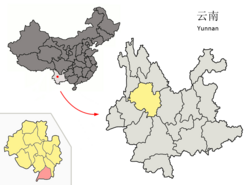
 Location of Nanjian County (pink) and Dali Prefecture (yellow) within Yunnan province of China | |
| Country | China |
| Province | Yunnan |
| Prefecture | Dali |
| Area | |
• Total | 1,731.63 km2 (668.59 sq mi) |
| Population | |
• Total | 217,604 |
| • Density | 130/km2 (330/sq mi) |
| Postal code | 675700 |
| Area code | 0872 |
| Website | http://nj.dali.gov.cn/ |
Nanjian Yi Autonomous County (南涧彝族自治县; pinyin: Nánjiàn yízú Zìzhìxiàn) is a county in the Dali Bai Autonomous Prefecture located in the southwestern province of Yunnan, China.
Ethnic groups
The Nanjian County Almanac (1993) lists the following ethnic groups.
- Yi (Western and Central Yi languages)
- Black Yi, White Yi
- Luoluo 倮倮, Black Luoluo 黑倮倮, White Luoluo 白倮倮
- Tuzu 土族
- Xiangtang 香堂
- Micha 密岔
- Laluobo 腊罗拨/腊鲁拨
- Enibo 额尼拨 (Central Yi)
- Misabo 迷撒拨
- Hui
- Bai (only some can speak Bai)
- Miao
- White Miao 白苗 (Menglou 孟镂)
- Green Miao 青苗 (Mengsa 孟撒): in Guihuaqing 桂花箐,[1] Weibixi Township 唯碧溪乡
- Chinese Miao 汉苗 (Mengzhua 孟抓)
- Bulang (autonym: Pu 濮; exonyms: Puman 濮曼, Pumanzi 濮蛮子): along the Jiancang River 涧沧江 in Wangjiang 望江[2]、Wanzi 湾子[3]、Lelongzhai 乐龙寨[4]、Goujie 狗街[5]、Yanzijiao 岩子脚[6][7]、Luodihe 落底河[8]
- Lisu
- Han
In Nanjian County, ethnic Bulang are located in Banqiao Village 板桥村,[9] Langcang Township 浪沧乡 (Dali Prefecture Almanac, Vol. 9 1998:127).
Transportation
References
- ^ http://www.ynszxc.gov.cn/villagePage/vIndex.aspx?departmentid=244131
- ^ http://www.ynszxc.gov.cn/villagePage/vIndex.aspx?departmentid=243412
- ^ http://www.ynszxc.gov.cn/villagePage/vIndex.aspx?departmentid=243413
- ^ http://www.ynszxc.gov.cn/villagePage/vIndex.aspx?departmentid=243415
- ^ http://www.ynszxc.gov.cn/villagePage/vIndex.aspx?departmentid=243416
- ^ http://www.ynszxc.gov.cn/villagePage/vIndex.aspx?departmentid=243421
- ^ http://www.ynszxc.gov.cn/villagePage/vIndex.aspx?departmentid=243344
- ^ http://www.ynszxc.gov.cn/villagePage/vIndex.aspx?departmentid=243410
- ^ http://www.ynszxc.gov.cn/villagePage/vIndex.aspx?departmentid=243321
External links
25°02′35″N 100°30′00″E / 25.04306°N 100.50000°E
