
Nikolassee
Nikolassee | |
|---|---|
 | |
Location of Nikolassee in Steglitz-Zehlendorf and Berlin  | |
| Country | Germany |
| State | Berlin |
| City | Berlin |
| Borough | Steglitz-Zehlendorf |
| Founded | 1901 |
| Area | |
| • Total | 19.6 km2 (7.6 sq mi) |
| Elevation | 105 m (344 ft) |
| Population (2008-06-30) | |
| • Total | 15,899 |
| • Density | 810/km2 (2,100/sq mi) |
| Time zone | UTC+01:00 (CET) |
| • Summer (DST) | UTC+02:00 (CEST) |
| Postal codes | (nr. 0606) 14129, 14163, 14193 |
| Vehicle registration | B |
Nikolassee is a locality (Ortsteil) of Berlin in the borough (Bezirk) of Steglitz-Zehlendorf. Until the latter was created in 2001, Nikolassee was part of the borough of Zehlendorf.
History
In 1901 it was built as the Villenkolonie Nikolassee, so named after the lake Nikolassee.[1] In 1902 the railway station was completed.[2] Originally an independent Prussian municipality, Nikolassee was incorporated into Berlin with the Greater Berlin Act of 1920. Part of West Berlin during the "Cold War", its southern border with the municipality of Kleinmachnow, at the same time the border between the American Sector and what was to be the GDR was fortified by the Berlin Wall between 1961 and 1989. Located on the motorway A 115 was the "Checkpoint Bravo" Drewitz-Dreilinden, built in 1969.[3]
Geography
Nikolassee is in the south-west of Berlin, near the road to Potsdam, southeast of the forest of Grunewald. The river Havel separates it from Kladow and Gatow, in Spandau. Other localities bordering with Nikolassee are Wannsee, Zehlendorf and Grunewald (this one in Charlottenburg-Wilmersdorf district [4]). Its southern neighbour Kleinmachnow is a municipality in Potsdam-Mittelmark district, Brandenburg. The residential areas of Nikolassee and Grunewald are separated by the Grunewald forest.
Aside from the Nikolassee, two other lakes are partially located in the locality: The Großer Wannsee with the "Strandbad Wannsee" [5] and Schlachtensee. The islets of Lindwerder [6] and Schwanenwerder, situated next to the eastern shore of the Havel, also belongs to this locality.
Transport
Nikolassee is served by the S-Bahn lines S1, S5 [7] and S7, at the homonymous station. The locality is also crossed by the motorway A 115 (the former AVUS, exit "Spanischer Allee"), and by the federal highway B1.
Photogallery
-
 View of Schwanenwerder island
 -
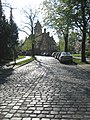 The station seen from Normannenstraße
 -
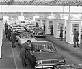 Checkpoint Bravo in 1972


References
- ^ The word See, in German, stands for lake
- ^ Template:De icon History of Nikolassee
- ^ Checkpoint Bravo location on Google Maps
- ^ Source: "ADAC StadtAtlas - Berlin-Potsdam". ed. 2007 - pages 193, 194 - ISBN 3-8264-1348-2
- ^ Source: "ADAC StadtAtlas - Berlin-Potsdam". ed. 2007 - pages 192, 193, 228, 229 - ISBN 3-8264-1348-2
- ^ Source: "ADAC StadtAtlas - Berlin-Potsdam". ed. 2007 - page 193 - ISBN 3-8264-1348-2
- ^ On Friday and Saturday nights only
External links
![]() Media related to Nikolassee at Wikimedia Commons
Media related to Nikolassee at Wikimedia Commons
| International | |
|---|---|
| National | |