Oyama, Shizuoka
Oyama
小山町 | |
|---|---|
Town | |
 Oyama Town Hall | |
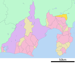
 Location of Oyama in Shizuoka Prefecture | |
| Country | Japan |
| Region | Chūbu Tōkai |
| Prefecture | Shizuoka Prefecture |
| District | Suntō |
| Area | |
| • Total | 136.13 km2 (52.56 sq mi) |
| Population (June 2014) | |
| • Total | 19,498 |
| • Density | 143/km2 (370/sq mi) |
| Time zone | UTC+9 (Japan Standard Time) |
| - Tree | Sakura |
| - Flower | Rapeseed |
| - Bird | Japanese Bush-warbler |
| Phone number | 0550-76-1111 |
| Address | 57-2 Fujimagari, Oyama-chō, Suntō-gun, Shizuoka-ken 410-1395 |
| Website | Official website |
| 410-1395 | |

Oyama (小山町, Oyama-chō) is a town located in Suntō District, Shizuoka Prefecture, Japan. As of June 2014, the town has an estimated population of 19,498 and a population density of 143 persons per km². The total area is 136.13 km².
Geography
Oyama is located in the far northeastern corner of Shizuoka Prefecture, bordering on Yamanashi and Kanagawa Prefectures. Located in between the Tanzawa Mountains and the foothills of Mount Fuji, the town has an average altitude of 800 meters, and has a cool climate with heavy rainfall. Some 65% of the town is covered in forest. Fuji Speedway is also located in this town.
Surrounding municipalities
- Shizuoka Prefecture
- Kanagawa Prefecture
- Yamanashi Prefecture
History
A small post town existed in this area since the Heian period, as Oyama is located at the base of the Ashigara Pass on the main route connecting the ancient provinces of Sagami with Kai and Suruga Provinces. The area was mostly tenryō territory under direct control of the Tokugawa shogunate in the Edo period. During the cadastral reform of the early Meiji period on April 1, 1889, the area was reorganized into the villages of Rokugo, Kannuma, Ashigara, Kitago and Subashiri within Suntō District, Shizuoka, two months after the opening of Suruga-Oyama Station on the Tōkaidō Main Line (now Gotemba Line).
The villages of Rokugo and Suganuma merged to form Oyama on August 1, 1912. Oyama annexed neighboring Ashigara on April 1, 1955, Kitago Village on August 1, 1956 and Subashiri on September 30, 1956. The Furusawa District of former Kitago transferred from Oyama to Gotemba on September 1, 1957.
Economy
Due to its proximity to the Tokyo metropolitan area, Oyama has a mixed economy of agriculture and light industry. Rice is the principal agricultural crop.
Transportation
Highway
- Tōmei Expressway - Gotemba Interchange
- Japan National Route 138
- Japan National Route 246
Rail
Sister city relations
 - Shōō, Okayama, Japan from November 24, 1973
 - Ōe, Kyoto, Japan from May 29, 1982
 - Mission, British Columbia, Canada, from October 7, 1996
Noted people from Oyama
- Sachiko Sugiyama - professional volleyball player
External links
![]() Media related to Oyama, Shizuoka at Wikimedia Commons
Media related to Oyama, Shizuoka at Wikimedia Commons
- Oyama official website (Japanese)
- Mount Fuji Subashiri Trail


