
Pacheri
For garment see Dupatta
Pacheri | |
|---|---|
village | |
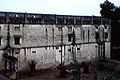
 Pacheri Fort | |
| Country | |
| State | Rajasthan |
| District | Jhunjhunu |
| Elevation | 958 m (3,143 ft) |
| Population (2008) | |
| • Total | 6,000 |
| Languages | |
| • Official | Hindi |
| Time zone | UTC+5:30 (IST) |
Pacheri is a village in the state of Rajasthan, India. It is inhabited by over 6,000 residents.
Geography
Pacheri is located at 28°09′N 75°56′E / 28.15°N 75.93°E.[1] It has an average elevation of 291 metres (958 feet).
References
-
Thakur Dhukal Singhji
-
 Fort Eastend
 -
 Fort Southend
 -
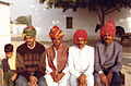
Villagers posing after a leopard hunt
-
Sangram Singhji posing with his gun
-
Sangram Singhji with his pets
-
Portrait Sangram Singhji
-
Pacheri Hunting Party Cira 1930
-
Pacheri Hunt
-
Pacheri Hunt
-
Pacheri Hunt
-
Pacheri Hunt
-
Pacheri Hunt
-
Pacheri Hunt
-
Pacheri Hunt
-
Sangram Singhji
-
 Sunil's Marriage - Birkali 1995 (Sangram Singhji's grandsons)
 -
 Sunil's Marriage - Birkali 1995 (Sangram Singhji's sons and grandson)


This article related to a location in Rajasthan is a stub. You can help Wikipedia by expanding it. |