Paulínia
Appearance
You can help expand this article with text translated from the corresponding article in Portuguese. (April 2010) Click [show] for important translation instructions.
|
This article needs additional citations for verification. (August 2014) |
22°45′40″S 47°09′15″W / 22.76111°S 47.15417°W
Paulínia | |
|---|---|
Municipality | |
| The Municipality of Paulínia | |
 | |
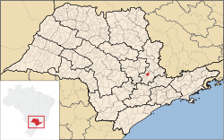
 Location of Paulinia | |
| Country | |
| Region | Southeast |
| State | São Paulo |
| Metropolitan Region | Campinas |
| Founded | 16 July, 1906 |
| Government | |
| • Mayor | Edson Moura Junior |
| Area | |
• Total | 138.78 km2 (53.58 sq mi) |
| Elevation | 590 m (1,940 ft) |
| Population (2015)[1] | |
• Total | 97,702 |
| • Density | 700/km2 (1,800/sq mi) |
| Time zone | UTC-3 (BRT) |
| • Summer (DST) | UTC-2 (BRST) |
| Postal Code | 13140-000 |
| Area code | +55 19 |
| Website | Paulinia, São Paulo |
Paulínia is a municipality in the state of São Paulo in Brazil. It is part of the Metropolitan Region of Campinas.[2] The population is 97,702 (2015 est.) in an area of 138.78 km².[1] The elevation is 590 m. It is known for hosting the Replan, the largest refinery of Petrobras.[3]
History
The municipality was created in 1964 from a part of the municipality of Campinas.
Sports
Paulínia Futebol Clube is the municipality's football club. They play their home games at Estádio Municipal Luís Perissinoto.
Neighborhoods
See also
- Theatro Municipal de Paulínia
- Atibaia River
- Jaguari River
- Escola Técnica de Paulínia
- Paulínia Shopping
Gallery
-
Condominiums at Morumbi neighborhood
-
Municipal Theater
-
Zeca Malavazzi Park
-
Estadio M. Luís Perissinoto
-
Antônio Batista Piva Avenue
References
- ^ a b c Instituto Brasileiro de Geografia e Estatística
- ^ Região Metropolitana de Campinas
- ^ "Replan Refinery, Brazil". Hydrocarbons-technology.com. Kable. Retrieved 10 August 2014.
Wikimedia Commons has media related to Paulínia.


