
River Swale
| River Swale | |
|---|---|
 The River Swale near Richmond. | |
| Physical characteristics | |
| Source | |
| • location | Confluence of Birkdale Beck and Great Sleddale Beck. |
| • elevation | 366 m (1,201 ft) |
| Mouth | |
• location | River Ure, near Myton-on-Swale, North Yorkshire |
• elevation | 11 m (36 ft) |
| Length | 117.8 km (73.2 mi) |
River Swale | |||||||||||||||||||||||||||||||||||||||||||||||||||||||||||||||||||||||||||||||||||||||||||||||||||||||||||||||||||||||||||||||||||||||||||||||||||||||||||||||||||||||||||||||||||||||||||||||||||||||||||||||||||||||||||||||||||||||||||||||||||||||||||||||||||||||||||||||||||||||||||||||||||||||||||||||||||||||||||||||||||||||||||||||||||||||||||||||||||||||||||||||||||||||||||||||||||||||||||||||||||||||||||||||||||||||||||||||||||||||||||||||||||||||||||||||||||||||||||||||||||||||||||||||||||||||||||||||||||||||||||||||||||||||||||||||||||||||||||||||||||||||||||||||||||||||||||||||||||||||||||||||||||||||||||||||||||||||||||||||||||||||||||
|---|---|---|---|---|---|---|---|---|---|---|---|---|---|---|---|---|---|---|---|---|---|---|---|---|---|---|---|---|---|---|---|---|---|---|---|---|---|---|---|---|---|---|---|---|---|---|---|---|---|---|---|---|---|---|---|---|---|---|---|---|---|---|---|---|---|---|---|---|---|---|---|---|---|---|---|---|---|---|---|---|---|---|---|---|---|---|---|---|---|---|---|---|---|---|---|---|---|---|---|---|---|---|---|---|---|---|---|---|---|---|---|---|---|---|---|---|---|---|---|---|---|---|---|---|---|---|---|---|---|---|---|---|---|---|---|---|---|---|---|---|---|---|---|---|---|---|---|---|---|---|---|---|---|---|---|---|---|---|---|---|---|---|---|---|---|---|---|---|---|---|---|---|---|---|---|---|---|---|---|---|---|---|---|---|---|---|---|---|---|---|---|---|---|---|---|---|---|---|---|---|---|---|---|---|---|---|---|---|---|---|---|---|---|---|---|---|---|---|---|---|---|---|---|---|---|---|---|---|---|---|---|---|---|---|---|---|---|---|---|---|---|---|---|---|---|---|---|---|---|---|---|---|---|---|---|---|---|---|---|---|---|---|---|---|---|---|---|---|---|---|---|---|---|---|---|---|---|---|---|---|---|---|---|---|---|---|---|---|---|---|---|---|---|---|---|---|---|---|---|---|---|---|---|---|---|---|---|---|---|---|---|---|---|---|---|---|---|---|---|---|---|---|---|---|---|---|---|---|---|---|---|---|---|---|---|---|---|---|---|---|---|---|---|---|---|---|---|---|---|---|---|---|---|---|---|---|---|---|---|---|---|---|---|---|---|---|---|---|---|---|---|---|---|---|---|---|---|---|---|---|---|---|---|---|---|---|---|---|---|---|---|---|---|---|---|---|---|---|---|---|---|---|---|---|---|---|---|---|---|---|---|---|---|---|---|---|---|---|---|---|---|---|---|---|---|---|---|---|---|---|---|---|---|---|---|---|---|---|---|---|---|---|---|---|---|---|---|---|---|---|---|---|---|---|---|---|---|---|---|---|---|---|---|---|---|---|---|---|---|---|---|---|---|---|---|---|---|---|---|---|---|---|---|---|---|---|---|---|---|---|---|---|---|---|---|---|---|---|---|---|---|---|---|---|---|---|---|---|---|---|---|---|---|---|---|---|---|---|---|---|---|---|---|---|---|---|---|---|---|---|---|---|---|---|---|---|---|---|---|---|---|---|---|---|---|---|---|---|---|---|---|---|---|---|---|---|---|---|---|---|---|---|---|---|---|---|---|---|---|---|---|---|---|---|---|---|---|---|---|---|---|---|---|---|---|---|---|---|---|---|---|---|---|---|---|---|---|---|---|---|---|---|---|---|---|---|---|---|---|---|---|---|---|---|---|---|---|---|---|---|---|---|---|---|---|---|---|---|---|---|---|---|---|---|---|---|---|---|---|---|---|---|---|---|---|---|---|---|---|---|---|
| |||||||||||||||||||||||||||||||||||||||||||||||||||||||||||||||||||||||||||||||||||||||||||||||||||||||||||||||||||||||||||||||||||||||||||||||||||||||||||||||||||||||||||||||||||||||||||||||||||||||||||||||||||||||||||||||||||||||||||||||||||||||||||||||||||||||||||||||||||||||||||||||||||||||||||||||||||||||||||||||||||||||||||||||||||||||||||||||||||||||||||||||||||||||||||||||||||||||||||||||||||||||||||||||||||||||||||||||||||||||||||||||||||||||||||||||||||||||||||||||||||||||||||||||||||||||||||||||||||||||||||||||||||||||||||||||||||||||||||||||||||||||||||||||||||||||||||||||||||||||||||||||||||||||||||||||||||||||||||||||||||||||||||
The River Swale is a river in Yorkshire, England and a major tributary of the River Ure, which itself becomes the River Ouse, emptying into the North Sea via the Humber Estuary.
The name Swale is from the Anglo-Saxon word Sualuae meaning rapid and liable to deluge. Annual rainfall figures of 1800mm p.a. in the headwaters and 1300mm p.a. in the lower waters over a drop of 148m in 32 km, gives proof to its name.[1] The river gives its name to the valley through which it flows, namely Swaledale.
The river and its valley are home to many types of flora and fauna typical to the Yorkshire Dales. Like similar rivers in the region, the river carves through several types of rock and has features typical of both river and glacial erosion. The River Swale has been a contributory factor in the settlements that have been recorded throughout its history. It has provided water to aid in the raising of crops and livestock, but also in the various mining activities that have occurred since Roman times and before.
The river is said to be the fastest flowing in England [2] and its levels have been known to rise 3 metres in 20 minutes.
Course
The source of the River Swale is at the confluence of the Birkdale Beck and the Great Sleddale Beck. The river flows north-north-east past lead mines on its northern bank and the end of Whitsundale and then easterly towards the first of many waterfalls in the headwaters. After flowing over Wain Wath Force the river continues south-east over Hoggarts Leap and Catrake Force near Keld, before it reaches East Gill Force and Kisdon Force. Shortly after Swinner Gill joins the river it swings sharply south towards the village of Muker where Straw Beck joins and the river turns east again. The river flows past Gunnerside towards Feetham where it turns north-east for a short while before returning east past Healuagh, Reeth and Grinton. The river then swings gently south-east and east below Marrick before turning north-eastward and then north past Marske.
It eventually returns eastward near Hudswell before it flows past the main town of the valley, Richmond. The river then starts a series of long south-east meanders past Brompton-on-Swale and under the A1 at Catterick Bridge before turning south past Catterick. The river continues long south and south-east meanders past Thrintoft and Morton-on-Swale. As it starts to pursue a more constant southerly flow it is joined by the River Wiske before passing Skipton-on-Swale, Catton, Topcliffe and Asenby. It then flows past Helperby and Myton-On-Swale before joining the River Ure.
River levels
| Monitoring station[3] | Station elevation | Low water level | High water level | Record high level |
|---|---|---|---|---|
| Park Bridge | 325 m (1,066 ft) | 0.00 m (0 ft) | 2.50 m (8.2 ft) | 3.04 m (10.0 ft) |
| Grinton Bridge | 178 m (584 ft) | 0 m (0 ft) | 1.5 m (4.9 ft) | 2.51 m (8.2 ft) |
| Richmond Lownthwaite Bridge | 114 m (374 ft) | 0.00 m (0 ft) | 2.0 m (6.6 ft) | 4.19 m (13.7 ft) |
| Catterick Bridge | 60 m (200 ft) | 0.3 m (0.98 ft) | 2.40 m (7.9 ft) | 3.48 m (11.4 ft) |
| Morton-on-Swale | 27 m (89 ft) | 0.13 m (0.43 ft) | 5.80 m (19.0 ft) | 6.47 m (21.2 ft) |
| Crakehill | 16 m (52 ft) | 0.22 m (0.72 ft) | 3 m (9.8 ft) | 5.45 m (17.9 ft) |
| Myton-on-Swale | 12 m (39 ft) | 0.44 m (1.4 ft) | 3.44 m (11.3 ft) | 6.02 m (19.8 ft) |
- Low and High Water Levels are an average figure.
Natural history
The River Swale and its valley support a range of habitats including broadleaved, mixed and conifer woodland as well as hay meadows and grasslands. Limestone scar, bracken, scrub and heather moorland can also be found. Amongst the species of tree that can be found are ash, birch, rowan and bird cherry along with shrubs such as hawthorn, hazel and holly. There are smaller populations of yew and sycamore. Pine, larch and spruce occur mostly in plantations with alder and willow common along the river banks. The many hay meadows are filled with buttercup and wood cranesbill.[4]
Geology
There are three distinct geological areas in Upper and Mid Swaledale. the upper reaches of the river flow over Carboniferous, Permian and Triassic rock, all of which are atop a layer of Lower Paleozoic beds.[5] These rocks are rich in minerals[6] and metalliferous sulfide ores such as Galena, Sphalerite, Chalcopyrite and Bravoite. There are also deposits of Fluorite, Barite, Witherite, Calcite, Dolomite and Barytocalcite.[7]
Along the valley sides can be seen the typical Dales geology of Yoredale beds, alternating strata of Limestone and Gritstone.[8] Small seams of coal, particularly around Tan Hill, have been found and worked. During the last Ice Age, the glacier that dominated the valley was responsible for broadening it and altering the course of the river around Keld and Round Howe. It was also responsible for cutting the Kisden Gorge. Retreat moraines lower in the river valley can be seen around Gunnerside and Grinton Bridge.
History
The earliest evidence of occupation in the river valley can be dated to the Mesolithic and Neolithic Ages with the discovery of flint tools and arrowheads. Around Harkerside are some small stone circles that date to the Bronze Age and some Iron Age defensive earthworks. Evidence of lead mining has been traced back to Roman times with finds at the Hurst mine.[8] This industry seemed to decline until after the Danish invasions of the area. During the major ecclesiastical building of the 12th and 13th centuries, lead became a valuable commodity and mining once again increased in the valley.[9] Evidence of the lead mining can still be seen from the remains of the 18th century practice of 'hushing' that involved creating turf dams across gills that were then released to wash away topsoil to expose the ore veins.
Around the 8th century, the river valley was settled by Angles who established themselves at Reeth, Stainton, Grinton Bridge and Fremington. Two hundred years later the upper valley was settled by Norsemen. After the Norman invasion, the lands of the valley were given to Count Alan of Brittany who built the castle at Richmond between 1071 and 1091. It was built on a bluff overlooking the River Swale.
Economy
Over the centuries, lead mining and cattle farming have been the main industries, but competition from the rest of the world saw them decline by the end of the 19th century.[9] Some crop farming also took place, most notably during the warm periods of the 13th century.
Tourism now plays a major role in the economy of the river valley. the Yorkshire Dales Cycle Way follows the valley between Fremington and Gunnerside. The Coast to Coast Walk passes through Richmond to Reeth and is crossed at Keld by the Pennine Way, which goes through the upper valley from Buttertubs Pass to Muker.[10]
Gallery
-
 Whitsundale Beck joins the River Swale
 -
 Wain Wath Force, near Keld, with the limestone cliffs of Cotterby Scar in the background.
 -
 Lower Catrake Force
 -
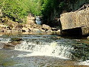 Kisdon Force on River Swale
 -
 River Swale near Muker
 -
 River Swale flowing under Downholme Bridge
 -
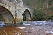
 Grinton Bridge
 -
 Ivelet Bridge
 -
 River Swale from Catterick Bridge
 -
 Morton Bridge, A684 Crossing the River Swale
 -
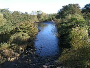
 River Swale near Brompton-on-Swale
 -
 River Swale from bridge near Brafferton


Lists
References
- ^ "Origin of name". Retrieved 28 January 2011.
- ^ "River Swale - Yorkshire Dales Rivers Trust". Yorkshire Dales Rivers Trust. Retrieved 27 October 2015.
- ^ "River levels". Retrieved 23 December 2010.
- ^ "Flora of the valley" (PDF). Retrieved 7 February 2011.
- ^ Scrutton, C. (1994). Yorkshire Rocks and landscapes, A Field Guide. Ellenbank Press. ISBN 1-873551-08-8.
- ^ Pattrick, R.; Polya, D. (1993). Mineralisation in the British Isles. Springer. ISBN 0-412-31200-X.
- ^ Dunham; Wilson (1985). Geology of the North Pennine Orefield Vol 2:Stainmore to Craven. HMSO London. Unknown ID:0L254726M.
- ^ a b Raistrick, A.; Jennings, B. (1966). History of Lead Mining in the Pennines. G. Kelsall. ISBN 0-946571-01-5.
- ^ a b Fieldhouse, R.; Jennings, B. (1978). History of Richmond & Swaledale. London: Phillimore & Co Ltd. ISBN 1-86077-364-8.
- ^ "Tourism" (PDF). Retrieved 7 February 2011.