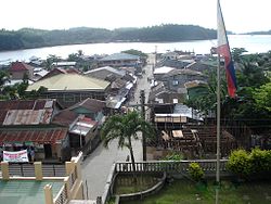
San Pascual, Masbate
Appearance
San Pascual | |
|---|---|
 | |
 Map of Masbate with San Pascual highlighted | |
| Country | Philippines |
| Region | Bicol (Region V) |
| Province | Masbate |
| District | 1st district |
| Barangays | 22 |
| Government | |
| • Mayor | Zacarina A. Lazaro |
| Area | |
• Total | 246.65 km2 (95.23 sq mi) |
| Population (2010)[3] | |
• Total | 44,753 |
| • Density | 180/km2 (470/sq mi) |
| Time zone | UTC+8 (PST) |
| Zip Code | 5420 |
| Dialing code | 56 |
San Pascual is a third class municipality in the province of Masbate, Philippines, located at the northernmost tip of Burias Island. According to the 2010 census, it has a population of 44,753 people.[3] In addition to the northern part of Burias Island, the islands of Busing, Templo (or Iniwaran,) and another six very small unpopulated islands belong to the municipality.
Barangays
San Pascual is politically subdivided into 22 barangays.[2]
- Boca Chica
- Bolod (Pob.)
- Busing
- Dangcalan
- Halabangbaybay
- Iniwaran
- Ki-Buaya (Rizal)
- Ki-Romero (Roxas)
- Malaking Ilog
- Laurente
- Mabini
- Mabuhay
- Mapanique
- Nazareno
- Pinamasingan
- Quintina
- San Jose
- Terraplin
- Sta. Cruz
- San Rafael
- Makahoy
- Cueva
Demographics
| Year | Pop. | ±% p.a. |
|---|---|---|
| 1990 | 33,396 | — |
| 1995 | 34,705 | +0.72% |
| 2000 | 37,868 | +1.89% |
| 2007 | 41,736 | +1.35% |
| 2010 | 44,753 | +2.57% |
| Source: National Statistics Office[3][4] | ||

References
- ^ "Municipalities". Quezon City, Philippines: Department of the Interior and Local Government. Retrieved 24 January 2013.
- ^ a b "Province: Masbate". PSGC Interactive. Makati City, Philippines: National Statistical Coordination Board. Retrieved 24 January 2013.
- ^ a b c "Total Population by Province, City, Municipality and Barangay: as of May 1, 2010" (PDF). 2010 Census of Population and Housing. National Statistics Office. Retrieved 20 January 2013.
- ^ "Province of Masbate". Municipality Population Data. LWUA Research Division. Retrieved 23 July 2013.
External links
- Philippine Standard Geographic Code
- Philippine Census Information
- [1]
- Local Governance Performance Management System
