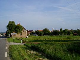
Schweyen
This is an old revision of this page, as edited by EP111 (talk | contribs) at 19:09, 29 May 2018 (ibx img). The present address (URL) is a permanent link to this revision, which may differ significantly from the current revision.
Schweyen | |
|---|---|
 The road into Schweyen | |
| Coordinates: 49°09′33″N 7°23′28″E / 49.1592°N 7.3911°E / 49.1592; 7.3911 | |
| Country | France |
| Region | Grand Est |
| Department | Moselle |
| Arrondissement | Sarreguemines |
| Canton | Bitche |
| Intercommunality | CC du Pays de Bitche |
| Government | |
| • Mayor (2008–2014) | Bruno Meyer |
| Area 1 | 11.35 km2 (4.38 sq mi) |
| Population (1999) | 311 |
| • Density | 27/km2 (71/sq mi) |
| Time zone | UTC+01:00 (CET) |
| • Summer (DST) | UTC+02:00 (CEST) |
| INSEE/Postal code | 57641 /57720 |
| Elevation | 236–361 m (774–1,184 ft) (avg. 300 m or 980 ft) |
| 1 French Land Register data, which excludes lakes, ponds, glaciers > 1 km2 (0.386 sq mi or 247 acres) and river estuaries. | |
Schweyen (Lorraine Franconian: Schweije) is a commune in the Moselle department of the Grand Est administrative region in north-eastern France.
The village belongs to the Pays de Bitche and to the Northern Vosges Regional Nature Park. It is located on the German border between the towns of Bitche, France and Zweibrücken, Germany. It has a population of 319 and an area of 1,135 hectares (2,800 acres).
It was first mentioned in 1322 under the name of "Schweien", which comes from the Old German name "Schweiga", which meant "cow" or "cattle".
Today, this village is noted for its brass band, "Amicale des Sapeurs Pompiers et Batterie Fanfare de Schweyen".
See also
External links
- Pages using gadget WikiMiniAtlas
- Articles with short description
- Short description is different from Wikidata
- Coordinates on Wikidata
- Pages using infobox settlement with image map1 but not image map
- Pages using infobox French commune with unknown parameters
- Commons category link is on Wikidata
- All stub articles
- Pages using the Kartographer extension


