Soldau concentration camp

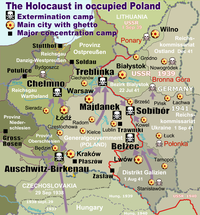
The Soldau concentration camp was a concentration camp established by Nazi Germany during World War II in Działdowo (German: Soldau), which after the occupation of Poland was part of East Prussia.
With the approval of Reinhard Heydrich, Otto Rasch founded the camp in the winter of 1939/40 as a Durchgangslager (Dulag), or transit camp, where political prisoners could be secretly executed.[1] In accordance with Action T4, mental patients at sanatoria in East Prussia and Regierungsbezirk Zichenau were taken to the Soldau camp; 1,558 patients were murdered by the Lange Commando in a gas van from May 21 to June 8, 1940.[2][3]
During the summer of 1941, the Soldau camp was reorganized as an Arbeitserziehungslager (literally "work education camp"). The labor camp's prisoners, who were divided into separate camps based on gender, were engaged in forced agricultural labor. This camp was closed in January 1945.[4]
13,000 out of 30,000 prisoners were murdered. Known victims include:
- Antoni Julian Nowowiejski, Roman Catholic bishop (1858-1941)[5]
- Leon Wetmański, bishop (1886-1941)[5]
- Mieczysława Kowalska, nun (1902-1941)
References
- ^ Henry Friedlander. The Origins of Nazi Genocide: From Euthanasia to the Final Solution. The University of North Carolina Press, 1997. ISBN 0-8078-4675-9
- ^ The Simon Wiesenthal Center. "Responses to Revisionist Arguments". Accessed November 28, 2006.
- ^ Jewish Virtual Library. "The Development of the Gas-Van in the Murdering of the Jews".Accessed November 28, 2006.
- ^ Keom.de. "Deutschland – ein Denkmal – ein Forschungsauftrag 1996 bis...". Accessed November 28, 2006.
- ^ a b Document 3264-PS. Nazi Conspiracy and Aggression, Volume V. US Government Printing Office, Washington DC: 1946, pp. 1018-1029.
