
User:Fabartus/tmp
Lehigh Canal | |
 The Lehigh Canal as seen from Guard Lock 8 & Lockhouse, Island Park Road, Glendon, Northampton County, PA | |
 Lower division of the Lehigh Canal, from Jim Thorpe, PA to Easton, PA | |
| Location | Lehigh River Upper: Nesquehoning, PA to White Haven, PA Lower: Mauch Chunk (Jim Thorpe) to Delaware River terminus: at Easton, PA |
|---|---|
| Coordinates | 40°46′09″N 75°36′13″W / 40.76917°N 75.60361°W |
| Built | 1818-1821; 24-27 upper: 1838-1843, Upper ruined & abandoned: 1862[2] |
| Architect | Canvass White, Josiah White |
| Architectural style | Fitted stone, iron and wood |
| NRHP reference No. | 78002437, 78002439, 79002179, 79002307, 80003553[1] |
| Added to NRHP | Earliest October 2, 1978 |


The Lehigh Canal (1818-1937) as an industrially important 'navigation', the type of canal built along the line of a river and parallel to the of the fall of the watercourse, built along two stretches of the Lehigh River in eastern Pennsylvania. As an important transportation infrastructure project, when completed in 1829[3][2] the upgrade of the 46.5-mile (74.8 km) lower canal into a true two way canal with advanced canal locks represented the very best of high tech in the early American Canal era.[3]
It is hard to overstate the importance the Lebigh Navigation had on United States industrial development,[2] but the modern mind unschooled in the difficulties of transportation in a day when most travel meant 'on foot', and water transport was the best way of getting around over any sustained distance (and often the fastest), might get some idea of the impact by considering how between 1822-24 White and Hazard had proven the fuel's worth and amply established they could reliably and regularly deliver Anthracite to the greater Delaware Valley plus increase annual production and deliveries year after year— that no less than three other major canal projects were almost immediately launched to tie into the outlet at Easton, Pennsylvania[3] and the transport capabilities on the Lehigh Canal:
- On the Delaware, as it began, the Lehigh could ship one-way economically to the docks at Philadelphia for coastal and international shipping.
- the Morris Canal directly across the Delaware River,
- and the Delaware and Raritan Canal, a bit up river.
- the belated 60 miles (97 km) Delaware Canal, designed to feed Philadelphia distribution from the terminus at Bristol.
The parent company, Lehigh Coal & Navigation Company (LC&N) is widely acknowledged as providing the earliest example of vertical integration of production resources in business economics, since they mined, shipped and used their own fuel to produce their end product (wire products, nails, foundry goods), controlling supply and output.[a] Whereas the lower canal was initially operated to service solely the parent companies coal mining operations by 1829 it had transitioned into a common carrier carrying freight back up the canal, including New Jersey Iron Ores. In the early 1830s it began servicing a few other competing coal customers[2] as a bulk carrier company and let other independent boat captains ride the works.
In contrast the 25.5 miles (41.0 km) long upper canal (completed in 1842), which rose over 600 feet (180 m) from the slack-water reservoir at Mauch Chunk's docks, was purpose built to carry coal from the vast mines of the Wyoming Valley, requiring a lock system with a much greater change in elevation and many more deep locks, as part of the 1837 amendments to the Main Line of Public Works (1826) legislation.

The upper and lower canals were constructed 20 years apart so that the 'grand Lehigh Canal', as some newsmen called it, stretched over two different heretofore unnavigable parts of the water course totaling 72-mile (116 km). The upper canal connected White Haven via the deep twisty rapids strewn Lehigh Gorge to the large slack water pool[b] above the first LC&N dam built below Mauch Chunk. This was the slack water pool at the upper terminus of the Lower Lehigh Canal.
From there, the canal ran down one set of locks to a special lock designed to weigh the assembled barges (image above & left), thence down through the Lehigh Valley through a two way lock system able to fit linked vessels over 120 feet (37 m) long along the way, fueling the American Industrial Revolution and the growth and development of the industrial powerhouses in Allentown, Bethlehem and the terminus at Easton, Pennsylvania on the Delaware River. Until the Delaware Canal embarrassment was rebuilt in 1832-34, LC&N had to often continue to build boats capable of traveling using river poles from the rivers mouth to the docks of Philadelphia.[3]
This created a great expense for LC&N and prevented reusing the boats, which had to be recycled by selling off the lumber used to construct them at great cost to LC&N.[3][2] In 1832 the lower canal when the Delaware Canal finally opened the company would no longer risk losing barges on the Delaware instead conveying them into the 60 miles (97 km) channel to Brighton. Unfortunately, the canal promised in 1824 as an alternative to the one LC&N proposed building was bungled by the inexperienced engineering of the Pennsylvania Canal Commission, so did not work—in the end they asked Josiah White and the LC&N to put it right, caused several years with reduced operability.[c] So important was securing a supply of Anthracite, opposite Easton, New Jersey businessmen had built the Morris Canal and via the Delaware River, the outlet at Easton, Pennsylvania could ship to the docks at Philadelphia and the Delaware and Raritan Canal.
Early Operations[edit]
The below sequence by Pennsylvania Historian Fred Brenckman in his 1913 update of the History of Carbon County[4] conveys a sense of the scope of difficulties during the first decade of operation:
| “ | The boats used during the early years on the Lehigh consisted of square boxes, or arks, from sixteen to eighteen feet wide, and about twenty-five feet long.
At first two of these were joined together by means of hinges, to permit of the undulations produced in passing the dams and sluices. As the men became more expert in their work and as the channel was straightened and improved, the number of sections was increased till, finally, their whole length reached one hundred and eighty feet. They were steered with long oars, like a raft. Boats of this description were used on the Lehigh to the end of the year 1831. During that year more than forty thousand tons of coal passed down the river, which required the building of so many boats that, had they all been joined in one length, they would have extended over a distance of more than thirteen miles. These boats made but one trip, being broken up in Philadelphia, where the planks were sold as lumber, while the iron work was returned to Mauch Chunk by land, a distance of eighty miles. The men employed in running the boats walked back for several years, when rough wagons were placed on the road for their accommodation by some of the tavern-keepers along the route. It soon became evident that the traffic could not be extended as fast as the demand for coal increased while it was necessary to build a new boat for each load of coal that was sent down; besides, the forests of the Laurytown Valley, where most of the lumber came from, were fast disappearing. Under these circumstances, it became apparent that the time had arrived for the introduction of slackwater navigation on the Lehigh. Accordingly, in 1827, the building of the Lehigh Canal, extending from Mauch Chunk to Easton, a distance of forty-six miles, was begun. The engineer in charge of the work was Canvass White, who had taken a prominent part in the construction of the Erie Canal across the state of New York. |
” |
| — Fred Brenckman | ||
History[edit]
The Lehigh Companies[edit]
The Lehigh Coal & Navigation Company and its founders Erskine Hazard and Josiah White sit firmly astride the history of the 1820s-1870s as a principle industrial revolution, and with much the same clout as a modern conglomerate such as General Motors, or General Electric or with the same sorts of innovations as are ascribed to IBM, Microsoft or the like. Leveraging of innovation and immense self-confidence, the Company founders
Early history[edit]
The Lower Canal[edit]
The lower canal (46.5 miles (74.8 km)) was built by the Lehigh Navigation Company as a coal road to service the Anthracite appetite of Eastern seaboard cities ahead of schedule, between 1818-1820 (down traffic only), and then gradually rebuilt (with locks fully supporting two way traffic) 1824-1827 by the Lehigh Coal & Navigation Company and continued in operation as a key transportation canal until the 1931. The lower canal connected the Southern Coal Region to the Delaware River basin, connecting Mauch Chunk (now Jim Thorpe, PA) to Easton, PA using a specially designed canal boat capable of making the one-way trip on the River as well.[n 1] It was used to carry anthracite gathered to the central Lehigh Valley to the urban markets of the northeast, especially Philadelphia, Pennsylvania, Trenton, New Jersey, and Wilmington, Delaware, but supported new growth industries in Bristol, PA, Allentown and Bethlehem. The privately funded canal was joined as part of the Pennsylvania Canal System, a complex system of canals and tow paths—and eventually railroads. The canal was sold for recreation use in the 1960s. Today, many parts of the canal or railroads later constructed to flank it, have been converted to the Delaware and Lehigh National Heritage Corridor (known colloquially as the 'D & L Trail'), a multi-use rail trail.
The Lehigh Coal Mine Company[edit]
The Lehigh Coal Mine Company (LCMC) was founded in 1792, a few months after Anthracite coal was discovered at Sharpe Mountain, a peak of the Pisgah Ridge near to the location that became Summit Hill, PA, and its principals would secure rights to over 10,000 acres before the Lehigh Canal was created. Where that enterprise found it fairly easy to find and mine coal, which occurred in outcrops and vertically aligned shafts near the original find, the mine output needed laboriously loaded onto pack animals which had to carry the coal nine miles to the Lehigh shores. There, the company had to build skiffs using local stands of timber, which then needed manned by stout hearts which had to brave and survive running the various Rapids along the lower Lehigh River. Having no company officer willing to manage from the field, the LCMC hired contractors, or sent out teams over the years which had only sporadic success in getting a boat filled with coal to the markets of Philadelphia. Yet the Eastern cities were undergoing a deforestation caused energy crisis—fire wood for heating buildings, and charcoal for working or making iron was becoming dear to purchase and hard to find by the time of the War of 1812. Prior to the war, so dismal was the LCMC company's record of getting coal to market, that coal imported from England was cheaper to find and more reliable to repurchase. The war gave a small boost to the company's aspirations, and the LCMC sent an expedition which after a year, returned in 1814 after building five boats but able to bring only two to market. They were both bought by the same party, and it was the last straw for many of the companies backers.
Lower Lehigh Canal[edit]
With the discovery of large surface deposits of anthracite coal, the Lehigh Coal Mine Company (LCMC) was formed in 1792 to secure the mineral rights to vast areas of wilderness west of the Lehigh River ranging beyond to the outcrops atop Sharpe Peak of Pisgah Ridge near present-day Summit Hill. The LCMC lacked a principle investor as a hands-on-manager and periodically hired teams to trek to the wilderness to build 'Arks' along the Lehigh near the turnpike operated from Lausanne (1800s Township)[d] above Mauch Chunk to the Susquehanna River valley (passed by Beaver Meadows and the eventual Beaver Meadows mines) and then attempted to transport the coal down the Lehigh River to the Delaware River and on to the docks in Philadelphia. The lack of steady effort and an intimately involved company officer in the operations returned sketchy results, most often the expeditions would loose arks on the rapids of the Lehigh and so the LCMC made little profits, and only sporadic efforts over two decades. Inspired by the energy shortfall during the blockade of the War of 1812, the LCMC sent a large expedition out in 1813, which started down the river in spring of 1814 with five arks laden with coal. Only two of them made it to Philadelphia, and both were purchased by Josiah White and partner Erskine Hazard. The LCMC board in its disgust confirmed the unreliability of the fuel source when they let it be known they planned no further risky expeditions as too costly, giving White and Hazard the idea of purchasing the rights to operate the mining company. In the fall of 1814 they mounted an expedition to survey the Lehigh's problems and those of the coal mine and transportation needs for getting its output to the River reliably and regularly.
Initial construction[edit]
The lower Lehigh Canal improvements were initially designed and engineered by LC&N founder Josiah White[5]Cite error: There are <ref> tags on this page without content in them (see the help page). after they'd very quickly become disenchanted with the decisions and strategies of the Schuykill Canal's board of directors,[5] so by the winter of 1814 were very interested in exploring the option of getting coal from Lehigh valley down to Philadelphia the more than 100 miles (160 km), one way or another.[5]
, but by late 1822 just as Anthracite was achieving early acceptance and the skepticism was waningCite error: There are <ref> tags on this page without content in them (see the help page). the drain of building sacrificial 'Coal Arks' for every load delivered to the docks of Philadelphia in 1822 as the LC&N operations were just hitting stride was already a worry to the managing board of directors.[6] By mid-1822, managing director Josiah White was consulting with Canvass White, an veteran designing engineer of New York's Erie Canal locks, and by late 1822 had shifted construction efforts from bolstering and improving the one-way system begun in 1818 with ambitious two-way dams and lock construction capable of taking both a steam tug and a coastal cargo ship all 45.6 miles (73.4 km) from the Delaware to the slack water pool at Mauch Chunk.
Economics of deforestation[edit]
In 1823, having built and tested four such locks Josiah White made a formal proposal to continue the improvements all the way down the Lehigh, but also including shipping locks along the 62 miles (100 km) of the Delaware River at LC&N expense.<
> via a connection with the Pennsylvania Canal (Delaware Division) in Easton.
to 1829.
The enlarged Lehigh Navigation extended 46 miles (74 km) between Mauch Chunk, Pennsylvania (present-day Jim Thorpe) and Easton with 52 locks, eight guard locks, eight dams and six aqueducts, allowing the waterway to overcome a difference in elevation of over 350 feet (107 m). A weigh lock determined canal boat fees a half mile (1 km) south of Mauch Chunk. A connection across the Delaware River to the Morris Canal through New Jersey allowed the coal from the Lehigh Canal to be shipped more directly to New York City.
Expansion[edit]
The upper Lehigh Canal was designed by Canvass White, an engineer of New York's Erie Canal, and was constructed between 1837 and 1843, as authorized by the 1837 revision of the Main Line of Public Works. The upper Lehigh was a twisty rapids strewn watercourse with steep sides, a large part of which was located in a ravine, the Lehigh Gorge. The village of White Haven, PA is at the upper end of the navigation, and inspired by the Allegheny Portage Railroad the legislature sought to more effectively connect the vast coal deposits of the Wyoming Valley to the Delaware basin cities, noted above. The project included three major railroad projects, which LC&N created a new subsidiary, the Lehigh and Susquehanna Railroad (LH&S) to implement; north to south these were the Rail connection from the Pennsylvania Canal landing docks at Pittston, PA to an assembly railyard at Ashley, PA; the Ashley Planes incline plane railway to Penobscot Knob and Mountain Top, PA, and lastly, a marshaling yard at Mountain Top with a rail road running down a ribs of a ridgeline down to White Haven and the new upper canal docks. During the 1830s, an extension of 26 miles (42 km) to White Haven, Pennsylvania, which included 20 dams and 29 locks, was constructed, covering a difference in elevation of over 600 feet (183 m) to Mauch Chunk. In 1855, as alternative sources opened to steal market share, the canal reached its peak of more than one million tons of cargo. After that, coal mined in the Schuylkill Valley supplanted coal supplied by the Lehigh Canal.
Demise[edit]
The demise of the canal began with competition from railroads and the catastrophic flood of June 4, 1862. The canal was used as a means of transportation until the 1940s (about a decade after other similar canals ceased operations), making it the last fully functioning towpath canal in North America. In 1962, most of it was sold to private and public organizations for recreational use.
Recent history[edit]
Several segments of the canal were listed on the National Register of Historic Places in 1979, under listing names "Lehigh Canal", "Carbon County Section of the Lehigh Canal" (#79002179), "Lehigh Canal: Eastern Section Glendon and Abbott Street Industrial Sites" (#78002437), "Lehigh Canal; Allentown to Hopeville Section" (#79002307) and others. For the Carbon County section, also known as "Upper Canal Lock #1 to Lower Canal Dam #3", the listing included 30 contributing structures.[7]
The Eastern section runs along the Lehigh River from Hopeville to the confluence of the Lehigh and Delaware Rivers in Easton, Pennsylvania and includes the Chain Bridge, which was separately NRHP-listed in 1974. The Eastern section listing is for a 260-acre (110 ha) area with three contributing buildings, seven contributing sites, and 11 contributing structures.[7]
The Allentown to Hopeville section is a 53.9-acre (21.8 ha) area that includes Greek Revival and vernacular Federal architecture among its one contributing building and 13 contributing structures.[7]
Activities[edit]
An 8-mile (13 km) segment of the canal towpath has been converted into a multi-use trail that runs from Freemansburg through Bethlehem to Allentown. The trail runs along the river and active railroad tracks. A section near Jim Thorpe is accessible to recreational users. The final section in Easton is maintained and operated by the National Canal Museum. Other short sections are accessible, but there are parts of the canal towpath that have been worn by the elements and are not safe to access.[8]
Notes[edit]
- ^ The delay in completing the Delaware Canal is listed as an extra expense in the annual reports of LC&N.
Pictures[edit]
-
 The canal passing through Bethlehem, 1907
 -
 Remains of Lock 25, 2006
 -
 Image of Gate entrance of Lock 28
 -
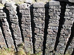 Stacked rock detail of lock wall of Lock 28 near White Haven, 2008


See also[edit]
- Delaware and Lehigh National Heritage Corridor
- Pennsylvania Canal (Delaware Division) – a sister canal along the Delaware River that provided a connection to the Philadelphia markets via a link up in Easton
- Morris Canal – a New Jersey canal that provided direct access to the New York City markets via a cross-Delaware River connection in Phillipsburg, New Jersey
- List of canals in the United States
References[edit]
- Bartholomew, Ann M.; Metz, Lance E.; Kneis, Michael (1989). DELAWARE and LEHIGH CANALS, 158 pages (First ed.). Oak Printing Company, Bethlehem, Pennsylvania: Center for Canal History and Technology, Hugh Moore Historical Park and Museum, Inc., Easton, Pennsylvania. ISBN 0930973097. LCCN 89-25150.
- ^ "National Register Information System". National Register of Historic Places. National Park Service. March 13, 2009.
- ^ a b c d e Fred Brenckman (1884). "Chapter II., 1913 revision". In (Ancestry.com excerpted e-reprint) (ed.). HISTORY OF CARBON COUNTY PENNSYLVANIA. J. Nungesser, Harrisburg, PA.
{{cite book}}: External link in|editor= - ^ a b c d e f g h Cite error: The named reference
DELandLHcanwas invoked but never defined (see the help page). - ^ Fred Brenckman (1884). HISTORY OF CARBON COUNTY PENNSYLVANIA. J. Nungesser, Harrisburg, PA (Project Gutenberg e-reprint).
- ^ a b c Bartholomew, Ann M.; Metz, Lance E.; Kneis, Michael (1989). DELAWARE and LEHIGH CANALS, 158 pages (First ed.). Oak Printing Company, Bethlehem, Pennsylvania: Center for Canal History and Technology, Hugh Moore Historical Park and Museum, Inc., Easton, Pennsylvania. p. 4-5. ISBN 0930973097. LCCN 89-25150.
- ^ Alfred Mathews & Ausin N. Hungerford (1884). The History of the Counties of Lehigh & Carbon, Commonwealth of Pennsylvania. Philadelphia: Ancestry.com, Transcribed from the original in April 2004 by Shirley Kuntz.
- ^ a b c "National Register Information System". National Register of Historic Places. National Park Service. July 9, 2010.
- ^ "Lehigh Canal". National Canal Museum. Retrieved November 23, 2013.
External links[edit]
- Historic American Engineering Record (HAER) No. PA-133, "Lehigh Canal, Easton Dam"
- Historic American Engineering Record (HAER) No. PA-136, "Lehigh Canal, Outlet Lock"
- Historic American Engineering Record (HAER) No. PA-139, "Lehigh Canal, Guard Lock 8 & Lockhouse"
- Historic American Engineering Record (HAER) No. PA-140, "Lehigh Canal, Lock 44"
- Historic American Engineering Record (HAER) No. PA-149, "Lehigh Canal, Lock 40"
- Historic American Engineering Record (HAER) No. PA-153, "Lehigh Canal, Hokendauqua Dam"
- Historic American Engineering Record (HAER) No. PA-158, "Lehigh Canal, Guard Lock 5"
- Historic American Engineering Record (HAER) No. PA-160, "Lehigh Canal, Lock 25"
- Historic American Engineering Record (HAER) No. PA-162, "Lehigh Canal, Lock 20"
- Historic American Engineering Record (HAER) No. PA-165, "Lehigh Canal, Lock 10"
- Historic American Engineering Record (HAER) No. PA-171, "Lehigh Canal, Slate Dam"
- Historic American Engineering Record (HAER) No. PA-176, "Lehigh Canal, Freemansburg"
- National Canal Museum: Lehigh Navigation
- Historic photos of the Lehigh Coal and Navigation Canal
- Delaware & Lehigh Canal State Heritage Corridor
- Lehigh Canal History

Cite error: There are <ref group=lower-alpha> tags or {{efn}} templates on this page, but the references will not show without a {{reflist|group=lower-alpha}} template or {{notelist}} template (see the help page).