
User:Jhnola/Neighborhoods in New Orleans
- In 1980 the New Orleans City Planning Commission divided the city into 13 planning districts and 72 distinct neighborhoods. [1]
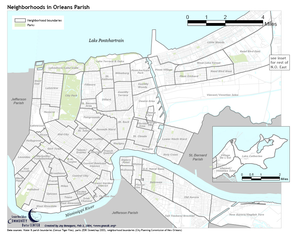
See Orleans Parish neighborhood map
While most of these assigned boundaries match with traditional local designations, some others differ from common traditional use. This is a result of the City Planning Commission's wish to divide the city into sections for governmental planning and zoning purposes without crossing United States Census tract boundaries. While most of the listed names have been in common use by New Orleanians for generations, some designated names are rarely heard outside the Planning Commission usage.
East Bank of the Mississippi River
[edit](District 1a) Central Business District - CBD
[edit]- Central Business District
- Originally a residential area, the Central Business District or CBD began commercialization after the Civil War.[3]
- In addition to the many commercial buildings in the area, the district houses many attractions including: The National World War II Museum, Mercedes Benz Superdome, Ernest N. Morial Convention Center, The Outlet Collection at Riverwalk, and The Smoothie King Center [4]
- Originally a residential area, the Central Business District or CBD began commercialization after the Civil War.[3]

.jpg)
(District 1b) Vieux Carre or French Quarter
[edit]- Vieux Carré, also called the French Quarter
- The most historic neighborhood in New Orleans, the Vieux Carre, houses several buildings built between 1974 and 1850.[5] It is popular amongst locals, tourists, and historians alike due to its rich history and plethora of restaurants, shops, and attractions, including:


(District 2) Central City / Garden District Area
[edit]- Central City [7]
- East Riverside
- Garden District [8] [7]
- Irish Channel [7] [9]
- Lower Garden District [4]
- Milan
- St. Thomas Development
- Touro
- Faubourg Lafayette
- Faubourg Livaudais
(District 3) Uptown / Carrollton Area [10]
[edit]
- Audubon, also known as University
- Black Pearl
- Broadmoor
- Dixon
- East Carrollton
- Freret
- Hollygrove
- Leonidas, also called West Carrollton
- Fontainebleau, also called Marlyville
- Uptown [11] [12]
- West Riverside


- Bayou St. John
- B.W. Cooper, formerly Calliope Projects
- Fairgrounds
- Faubourg St. John
- Gert Town, also called Zion City
- Iberville Development (Note: This area was built on the site of the infamous Storyville neighborhood.)
- Mid-City [13] [14]
- Parkview [15]
- Seventh Ward
- St. Bernard Projects
- Tremé/Lafitte [16]
- Tulane/Gravier

University Medical Center in Tulane/Gravier Area 
House on Onzaga Street in 7th Ward


(District 5) Lakeview Area
[edit]


(District 6) Gentilly Area
[edit]
- Dillard
- Filmore
- Gentilly Terrace [17]
- Gentilly Woods
- Lake Terrace/Lake Oaks
- Milneburg
- Pontchartrain Park
- St. Anthony
(District 7) Bywater Area
[edit]
- Bywater [18]
- Desire Area
- New Desire Projects: Abundance Square
- Faubourg Marigny [19]
- Florida Area
- Florida Projects
- St. Claude
- St. Roch
(District 8) Lower Ninth Ward Area
[edit]

Eastern New Orleans
[edit](District 9) Eastern New Orleans Area
[edit]
- Little Woods, also called Edge Lake
- Pines Village
- Plum Orchard
- Read Boulevard East, New Orleans|Read Boulevard East
- Read Boulevard West, New Orleans|Read Boulevard West
- West Lake Forest
(District 10) Village de L'Est
[edit]
(District 11) Venetian Isles / Lake Catherine
[edit]
West Bank of the Mississippi River
[edit](District 12) Algiers Area
[edit]
- Algiers Point [22] [6]
- U.S. Naval Support Area
- Aurora, also called Old Aurora; includes Huntlee Village and Walnut Bend
- Behrman, New Orleans
- Fischer Housing Development
- McDonogh, formerly called McDonoghville
- Tall Timbers / Brechtel
- New Aurora (Includes River Park, Cut Off, and Lower Coast)
(District 13) English Turn Area
[edit]
Latitude and Longitude of Neighborhoods
[edit]| Neighborhood | Longitude | Latitude |
|---|---|---|
| U.S. NAVAL BASE | -90.02609253 | 29.94608469 |
| ALGIERS POINT | -90.0516057 | 29.95246187 |
| WHITNEY | -90.04235744 | 29.94720026 |
| AUDUBON | -90.12145042 | 29.93299437 |
| OLD AURORA | -90 | 29.92444011 |
| B. W. COOPER | -90.09175301 | 29.95177397 |
| BAYOU ST. JOHN | -90.08651733 | 29.97607064 |
| BEHRMAN | -90.02643585 | 29.9348167 |
| BLACK PEARL | -90.13488293 | 29.93589521 |
| BROADMOOR | -90.10381222 | 29.9465681 |
| MARLYVILLE - FONTAINEBLEAU | -90.11346817 | 29.95300103 |
| GERT TOWN | -90.10582924 | 29.96028871 |
| MID-CITY | -90.09939194 | 29.97040133 |
| ST. CLAUDE | -90.03926754 | 29.97181404 |
| CENTRAL BUSINESS DISTRICT | -90.07445812 | 29.95002632 |
| FRENCH QUARTER | -90.06437302 | 29.95883865 |
| CENTRAL CITY | -90.086689 | 29.93946537 |
| LAKE CATHERINE | -89.76104736 | 30.08810775 |
| VILLAGE DE LEST | -89.90112305 | 30.07325354 |
| VIAVANT - VENETIAN ISLES | -89.945755 | 30.00311157 |
| NEW AURORA - ENGLISH TURN | -89.94197845 | 29.90732938 |
| TALL TIMBERS - BRECHTEL | -90.01338959 | 29.91030537 |
| FISCHER DEV | -90.04154205 | 29.93239931 |
| McDONOGH | -90.05141258 | 29.94340726 |
| LOWER GARDEN DISTRICT | -90.06814957 | 29.93485389 |
| ST. THOMAS DEV | -90.07098198 | 29.92436572 |
| EAST RIVERSIDE | -90.09432793 | 29.91960476 |
| IRISH CHANNEL | -90.08565903 | 29.91633148 |
| TOURO | -90.09544373 | 29.923845 |
| MILAN | -90.09836197 | 29.93254808 |
| UPTOWN | -90.10788918 | 29.92644857 |
| WEST RIVERSIDE | -90.11672974 | 29.91618269 |
| EAST CARROLLTON | -90.12694359 | 29.94474598 |
| FRERET | -90.1071167 | 29.93715966 |
| GARDEN DISTRICT | -90.08505821 | 29.92793629 |
| LEONIDAS | -90.13097763 | 29.95359597 |
| HOLLYGROVE | -90.12299538 | 29.96727842 |
| TULANE - GRAVIER | -90.08522987 | 29.95961945 |
| TREME - LAFITTE | -90.07441521 | 29.96727842 |
| SEVENTH WARD | -90.06651878 | 29.97642379 |
| MARIGNY | -90.05587578 | 29.96504771 |
| ST. ROCH | -90.05209923 | 29.98214852 |
| DIXON | -90.11321068 | 29.97151663 |
| LAKEWOOD | -90.1199913 | 29.98549398 |
| NAVARRE | -90.11037827 | 29.98846764 |
| CITY PARK | -90.09372711 | 29.99917205 |
| LAKEVIEW | -90.10831833 | 30.00660499 |
| WEST END | -90.11861801 | 30.01366576 |
| LAKESHORE - LAKE VISTA | -90.09784698 | 30.02325275 |
| FILMORE | -90.07707596 | 30.01054422 |
| ST. BERNARD AREA | -90.08016586 | 29.99523236 |
| DILLARD | -90.06591797 | 29.99865172 |
| ST. ANTHONY | -90.06574631 | 30.01515218 |
| LAKE TERRACE & OAKS | -90.06420135 | 30.02867753 |
| MILNEBURG | -90.054245 | 30.01916539 |
| PONTCHARTRAIN PARK | -90.03931046 | 30.0219894 |
| GENTILLY WOODS | -90.03707886 | 30.00994963 |
| GENTILLY TERRACE | -90.05235672 | 30.00370621 |
| DESIRE AREA | -90.03330231 | 29.99389432 |
| FLORIDA AREA | -90.03742218 | 29.98021553 |
| FLORIDA DEV | -90.03252983 | 29.98170245 |
| LOWER NINTH WARD | -90.01304626 | 29.96891424 |
| BYWATER | -90.0302124 | 29.96534514 |
| HOLY CROSS | -90.01785278 | 29.95508328 |
| PINES VILLAGE | -90.02214432 | 30.01916539 |
| PLUM ORCHARD | -90.00188828 | 30.01604402 |
| READ BLVD WEST | -89.97922897 | 30.02005719 |
| READ BLVD EAST | -89.95519638 | 30.03551382 |
| WEST LAKE FOREST | -89.99210358 | 30.0270427 |
| LITTLE WOODS | -89.98386383 | 30.04190384 |
| FAIRGROUNDS | -90.0794363 | 29.98621882 |
| IBERVILLE | -90.07368565 | 29.95949861 |
Other divisions and designations
[edit]There are a number of traditional and historic divisions of New Orleans which may still be commonly heard of in conversation, but which do not correspond with City Planning Commission designations.
The 19th-century division of the city along the axis of Canal Street into downtown and uptown is a prime example. Various areas of the modern city which were separate towns in the past, such as Algiers and Carrollton, continue to be spoken of – but now as neighborhoods. The large area to the east of the Industrial Canal and north of the Mississippi River-Gulf Outlet Canal, little developed until the last third of the 20th century, is often referred to as Eastern New Orleans (or "New Orleans East," although that term usually refers to a smaller subset of the area).
See also
[edit]- Buildings and architecture of New Orleans
- Downtown New Orleans
- Uptown New Orleans
- Wards of New Orleans
- Housing Authority of New Orleans
- List of streets of New Orleans
References
[edit]- Data Analysis Unit, Economic Development Division, City of New Orleans (1985). An overview of New Orleans.
{{cite book}}: CS1 maint: multiple names: authors list (link)
- ^ Poche, Richard (March 2006). "City of New Orleans Planning Districts". Nola.gov City of New Orleans.
{{cite web}}: CS1 maint: url-status (link) - ^ "New Orleans' National Register Historic Districts" (PDF). Preservation Resource Center of New Orleans. 2017.
{{cite web}}: CS1 maint: url-status (link) - ^ "City of New Orleans Historic District Landmarks Commission Canal Street Historic District" (PDF). Nola.gov City of New Orleans. May 2011.
{{cite web}}: CS1 maint: url-status (link) - ^ a b "Central Business District & Lower Garden District" (PDF). Preservation Resource Center of New Orleans. 2017.
{{cite web}}: CS1 maint: url-status (link) - ^ "Vieux Carre Historic District National Register of Historic Places Inventory -- Nomination Form". National Register of Historic Places. 1977.
{{cite web}}: CS1 maint: url-status (link) - ^ a b "Vieux Carre & Algiers Point" (PDF). Preservation Resource Center of New Orleans. 2017.
{{cite web}}: CS1 maint: url-status (link) - ^ a b c "Irish Channel, Garden District, & Central City" (PDF). Preservation Resource Center of New Orleans. 2017.
{{cite web}}: CS1 maint: url-status (link) - ^ "City of New Orleans Historic District Landmarks Commission Garden District Historic District" (PDF). Nola.gov City of New Orleans. May 2011.
{{cite web}}: CS1 maint: url-status (link) - ^ "City of New Orleans Historic District Landmarks Commission Irish Channel Historic District" (PDF). Nola.gov City of New Orleans. May 2011.
{{cite web}}: CS1 maint: url-status (link) - ^ "City of New Orleans Historic District Landmarks Commission Carrollton Historic District". Nola.gov City of New Orleans. January 2019.
{{cite web}}: CS1 maint: url-status (link) - ^ "Uptown, Carrollton & Broadmoor" (PDF). Preservation Resource Center of New Orleans. 2017.
{{cite web}}: CS1 maint: url-status (link) - ^ "City of New Orleans Historic District Landmarks Commission Uptown Historic District". Nola.gov City of New Orleans. January 2019.
{{cite web}}: CS1 maint: url-status (link) - ^ "Mid-City, Parkview, Esplanade Ridge & South Lakeview" (PDF). Preservation Resource Center of New Orleans. 2017.
{{cite web}}: CS1 maint: url-status (link) - ^ "City of New Orleans Historic District Landmarks Commission Mid-City Historic District". Nola.gov City of New Orleans. January 2019.
{{cite web}}: CS1 maint: url-status (link) - ^ "City of New Orleans Historic District Landmarks Commission Parkview Historic District". Nola.gov City of New Orleans. January 2019.
{{cite web}}: CS1 maint: url-status (link) - ^ "City of New Orleans Historic District Landmarks Commission Treme Historic District" (PDF). Nola.gov City of New Orleans. May 2011.
{{cite web}}: CS1 maint: url-status (link) - ^ "New Marigny, Gentilly Terrace & Edgewood Park" (PDF). Preservation Resource Center of New Orleans. 2017.
{{cite web}}: CS1 maint: url-status (link) - ^ "City of New Orleans Historic District Landmarks Commission Bywater Historic District" (PDF). Nola.gov City of New Orleans. May 2011.
{{cite web}}: CS1 maint: url-status (link) - ^ "City of New Orleans Historic District Landmarks Commission Faubourg Marigny Historic District" (PDF). Nola.gov City of New Orleans. May 2011.
{{cite web}}: CS1 maint: url-status (link) - ^ "Faubourg Marigny, Bywater & Holy Cross" (PDF). Preservation Resource Center of New Orleans. 2017.
{{cite web}}: CS1 maint: url-status (link) - ^ "City of New Orleans Historic District Landmarks Commission Holy Cross Historic District" (PDF). Nola.gov City of New Orleans. May 2011.
{{cite web}}: CS1 maint: url-status (link) - ^ "City of New Orleans Historic District Landmarks Commission Algiers Point Historic District". Nola.gov City of New Orleans. April 2016.
{{cite web}}: CS1 maint: url-status (link)
External links
[edit]| Topics | |
|---|---|
| Government | |
| Colleges and Universities | |
| Sports |
|
| Festivals | |