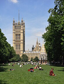
Victoria Tower Gardens

Victoria Tower Gardens is a public park along the north bank of the River Thames in London. As its name suggests, it is adjacent to the Victoria Tower, the south-western corner of the Palace of Westminster. The park, which extends southwards from the Palace to Lambeth Bridge, sandwiched between Millbank and the river, also forms part of the Thames Embankment.
Features
The park features:
- A cast of the sculpture The Burghers of Calais by Auguste Rodin, purchased by the British government in 1911 and positioned in the gardens in 1915.
- A 1930 statue of the suffragette Emmeline Pankhurst by Arthur George Walker
- The Buxton Memorial Fountain – originally constructed in Parliament Square, this was removed in 1940 and placed in its present position in 1957. It was commissioned by Charles Buxton MP to commemorate the abolition of slavery in 1834, dedicated to his father Thomas Fowell Buxton, and designed by Gothic architect Samuel Sanders Teulon (1812–1873) in 1865.
- A stone wall with two modern-style goats with kids – situated at the southern end of the Gardens.
- From 4 to 11 August 2014 the light installation "Spectra" by Japanese artist Ryoji Ikeda was situated in the gardens to commemorate the centenary of the start of the First World War.
-
Buxton Memorial Fountain
-
Emmeline Pankhurst Memorial
-
Rodin: The Burghers of Calais
Transport
The nearest London Underground stations are Westminster and Pimlico.
History

The Gardens were created during the 1870s by Joseph Bazalgette, and was part of a project for the Metropolitan Board of Works to provide London with a modern sewerage system.[citation needed]
The gardens were later expanded. This expansion was discussed in parliament in 1898 in the 'Victoria Embankment extension and St John's improvement bill'.[1] A number of wharves were compulsorily purchased, including Dorset Wharf (shown on 1885 map)[2] which was purchased from George Taverner Miller, son of Taverner John Miller, from where he ran a 'Sperm Oil Merchants and Spermaceti refining' business. The effects from this business and others were sold in 1905.[3]
External links
- School board map of the area 1872
- Boundary Commission map from 1885
- Waterloo, Westminster, Lambeth map 1896
- Details of compulsory purchase of Dorset Wharf
References
- ^ "VICTORIA EMBANKMENT EXTENSION AND ST. JOHN'S IMPROVEMENT BILL". Hansard Millbank. Retrieved 2008-09-14.
- ^ "Corporation of London". The National Archive. Retrieved 2008-09-14.
- ^ "Westminster changes in 1905" (PDF). Oxford Journals. Retrieved 27-12-30.
{{cite web}}: Check date values in:|accessdate=(help)


