
Aguada, Puerto Rico
Aguada
Municipio de Aguada | |
|---|---|
Town and Municipality | |
From top, left to right: Main plaza and Iglesia San Francisco de Asís de la Aguada (Church of San Francisco de Asís); Ismael "Chavalillo" Delgado Aguada Multi-use Coliseum; Hacienda Caño Las Nasas (Caño Las Nasas Plantation) and Coloso sugarmill; and panoramic shoreline view | |
.svg) Flag  Coat of arms | |
| Nicknames: | |
| Anthem: "Muchos siglos han pasado" | |
 Map of Puerto Rico highlighting Aguada Municipality | |
| Coordinates: 18°22′46″N 67°11′18″W / 18.37944°N 67.18833°W | |
| Sovereign state | |
| Commonwealth | |
| Founded | 1508–1510[1] |
| Founded by | Don Cristóbal de Sotomayor |
| Barrios | |
| Government | |
| • Mayor | Christian Cortés (Popular Democratic Party (Puerto Rico)) |
| • Senatorial dist. | 4 – Mayagüez |
| • Representative dist. | 18 |
| Area | |
| • Total | 45.55 sq mi (118.0 km2) |
| • Land | 30.93 sq mi (80.1 km2) |
| • Water | 14.62 sq mi (37.9 km2) 32% |
| Population (2020)[2] | |
| • Total | 38,136 |
| • Rank | 26th in the Puerto Rico |
| • Density | 840/sq mi (320/km2) |
| Demonym | Aguadeños |
| Time zone | UTC−4 (AST) |
| ZIP Code | 00602 |
| Area code | 787/939 |
| Major routes | |
| Website | aguada |


Aguada (/əˈɡwɑːdə/; Spanish: [aˈɣwaða], locally [aˈwaða]), originally San Francisco de Asís de la Aguada, is a town and municipality of Puerto Rico, located in the northwestern coastal valley region bordering the Atlantic Ocean, east of Rincón, south of Aguadilla, west of Moca; and north of Añasco and Mayagüez. It is part of the Aguadilla-Isabela-San Sebastián Metropolitan Statistical Area. Aguada's population is spread over 17 barrios and Aguada Pueblo (the downtown area and the administrative center of the city).
Etymology and nicknames[edit]
The name Aguada is a shortening of the town's original name San Francisco de Asís de la Aguada. The word aguada literally translates to "watery" or "watered down" from Spanish, possibly a reference to the town's strategic importance as a port in the Mona Passage and the Atlantic Ocean.
The municipality has many nicknames: La Villa de Sotomayor ("Sotomayor's Villa") is a reference to one of the town's Spanish founders, Cristóbal de Sotomayor; La Ciudad del Descubrimiento ("City of the Discovery") is a reference to the possibility that Christopher Columbus first landed in Puerto Rico at what is today the municipality's territory; El Pueblo Playero translates to "the beach town" and La Ciudad del Vaticano ("the Vatican's City") which references the town's early importance for Catholicism in the island.[3]
History[edit]
A Taíno settlement called Aymamón was located close to the Culebrinas River.[4][5]
Bahía de Aguada (Aguada Bay) in Aguada has historically been recognized as the location where Christopher Columbus first landed in Puerto Rico during his second voyage on 19 November 1493. However, it is believed by most historians that Bahía de Añasco (Añasco Bay) in the neighboring town of Añasco was the place of Columbus’ first landing and stay of two days in Puerto Rico before continuing to La Navidad, first European settlement in the Americas, in Haiti in Hispaniola.[6][7][8]
In July 1510, Cristóbal de Sotomayor received control of the area from Juan Ponce de León and renamed the town Villa de Sotomayor (Sotomayor Village).[9] However, in 1511 the settlement was attacked and burned by the local Taínos. That same year, the Spanish crown ordered a monastery be established in Puerto Rico, and the Ermita de Espinar was founded. The name of the area was then changed to San Francisco de Asís de la Aguada, since the friars were Franciscan. The monastery was finished in 1516.
In 1526, King Charles I of Spain officially founded the Aguada settlement. However, in 1529, Taínos attacked the monastery killing the friars and burning the settlement.[10] The Taínos, indigenous people of Puerto Rico, were believed to have practiced polytheism. As the Spanish began to colonize the Caribbean area, they wanted to convert the natives to Catholicism.[11] The Caribs destroyed a church of Franciscans in Aguada and killed five of its members in 1579.[12]
Still, Aguada resurfaced and became a stopover point for ships on their way to Spain from South America.[13] On September 17, 1692, King Charles II of Spain emitted a Royal Decree declaring Aguada a "village" and assigning Captain Juan López de Segura as War Lieutenant and Ordinary Mayor of the Villa de San Francisco de Asís de la Aguada.[10]
In 1737, Philip V, King of Spain, declared that all mail en route to Venezuela and other South American countries from Puerto Rico should exit from Aguada's ports, leading to the area's economic growth. Also, an increase in population has been attributed to possible desertions from foreign merchant ships.[14]
Puerto Rico was ceded by Spain in the aftermath of the Spanish–American War under the terms of the Treaty of Paris of 1898 and became an unincorporated territory of the United States. In 1899, the United States Department of War conducted its first census of Puerto Rico finding that the population of Aguada was 10,581.
In the early years of the 20th century, two disasters affected the town of Aguada. First, a huge fire in 1912 destroyed most of the town buildings, including the old city hall, which contained all the city archives. On October 11, 1918, at 10:14:42 local time an earthquake known as the San Fermín earthquake destroyed the church and other structures.[15] At Rio Culebrinas, 1000 kg blocks of limestone from the wrecked Columbus monument were carried inland to distances of 46–76 meters (151–249 feet) by waves 4.0 m (13.1 ft) high.[16]
Hurricane María on September 20, 2017, triggered numerous landslides in Aguada, with its strong winds and heavy rain.[17][18] Infrastructure and an estimated 8,000 homes in Aguada were damaged or destroyed. Two police officers died when they were caught in the flooded Culebrinas River.[19]
On July 16, 2023 a tornado touched down in Aguada, producing EF1 damage which included tearing a roof from a house and damage to power lines.[20] The city is notorious for stormy weather.
Folklore[edit]

El Matador de Tiburones (The Aguada Shark Killer) is folklore that comes out of Aguada and was written around 1640. It tells of a young man who was accustomed to fighting sharks but was without his religious charm. When asked to demonstrate his shark-fighting capabilities to visiting Spanish dignitaries, he hesitated. All day and night he pondered whether he could fight a shark without his religious charm. Even though the Spaniards had increased their offer to 3 bars of gold the matador was hesitant. In the morning, as the shark came into the bay, the spectators who were gathered on the beach yelled in anticipation, and El Matador de Tiburones, as the young man was called, was unable to stop himself. He jumped into the open sea pursuing the shark and fought it with his bare hands. He was nearly killed and after receiving his prize of gold, vowed to never again fight a shark.[21]
Geography[edit]
Aguada is located in the west coast of the island of Puerto Rico. It borders the Atlantic Ocean and Aguadilla on the north, Moca on the east, Añasco on the south, and Rincón on the west. Aguada is part of the Coastal Plains of the West, which features alluvial and fertile terrain. Although the terrain is mostly plain, there are some mountains to the south and southeast.[22][23]
Among the mountains located in Aguada are the Atalaya Peak, located within the limits of Aguada and Rincón. Also, San Francisco Mountain, which is popularly known as the birth point of the Cordillera Central, and Cerro Gordo, peaking at 853 feet (260 meters).[24]
Water features[edit]
Aguada's hydrographic system is composed of the Río Culebrinas, Río Grande, Río Cañas, Río Culebra, Río Guayabo, and Río Ingenio. All of these rivers flow into the Mona Passage.[22] According to a news article by Primera Hora, there are ten beaches in Aguada.[25] Aguada has an area of 45.55 square miles and 14.62% are water bodies.[26]
Barrios[edit]

Like all municipalities of Puerto Rico, Aguada is subdivided into barrios:[27][28][29][30]
Sectors[edit]
Barrios (which are, in contemporary times, roughly comparable to minor civil divisions)[31] in turn are further subdivided into smaller local populated place areas/units called sectores (which means sectors in English). The types of sectores may vary, from normally sector to urbanización to reparto to barriada to residencial, among others.[32][33]
Special Communities[edit]
Comunidades Especiales de Puerto Rico (Special Communities of Puerto Rico) are marginalized communities whose citizens are experiencing a certain amount of social exclusion. A map shows these communities occur in nearly every municipality of the commonwealth. Of the 742 places that were on the list in 2014, the following barrios, communities, sectors, or neighborhoods were in Aguada: Parcelas Noboa Vieja and Parcelas Noboa Nuevas in Guanaquilla barrio, Calle San Francisco, Calle San José, Comunidad Las Flores, Sector Las Bimbas in Luyando comunidad, Parcelas Matías, Parcelas Nieves, and Sector García.[34]
Climate[edit]
| Climate data for Coloso, Puerto Rico (1991–2020 normals, extremes 1900–present) | |||||||||||||
|---|---|---|---|---|---|---|---|---|---|---|---|---|---|
| Month | Jan | Feb | Mar | Apr | May | Jun | Jul | Aug | Sep | Oct | Nov | Dec | Year |
| Record high °F (°C) | 100 (38) |
96 (36) |
97 (36) |
98 (37) |
97 (36) |
98 (37) |
98 (37) |
97 (36) |
98 (37) |
96 (36) |
100 (38) |
95 (35) |
100 (38) |
| Mean daily maximum °F (°C) | 84.3 (29.1) |
84.7 (29.3) |
85.6 (29.8) |
86.3 (30.2) |
87.4 (30.8) |
88.8 (31.6) |
88.8 (31.6) |
89.0 (31.7) |
89.1 (31.7) |
88.5 (31.4) |
86.7 (30.4) |
84.9 (29.4) |
87.0 (30.6) |
| Daily mean °F (°C) | 75.1 (23.9) |
75.2 (24.0) |
76.1 (24.5) |
77.4 (25.2) |
79.2 (26.2) |
80.4 (26.9) |
80.7 (27.1) |
80.9 (27.2) |
80.9 (27.2) |
80.3 (26.8) |
78.6 (25.9) |
76.3 (24.6) |
78.4 (25.8) |
| Mean daily minimum °F (°C) | 65.9 (18.8) |
65.7 (18.7) |
66.7 (19.3) |
68.6 (20.3) |
70.9 (21.6) |
72.1 (22.3) |
72.6 (22.6) |
72.8 (22.7) |
72.8 (22.7) |
72.1 (22.3) |
70.6 (21.4) |
67.7 (19.8) |
69.9 (21.1) |
| Record low °F (°C) | 45 (7) |
46 (8) |
50 (10) |
51 (11) |
56 (13) |
58 (14) |
56 (13) |
60 (16) |
59 (15) |
59 (15) |
57 (14) |
50 (10) |
45 (7) |
| Average precipitation inches (mm) | 2.47 (63) |
2.67 (68) |
3.25 (83) |
5.28 (134) |
9.82 (249) |
8.70 (221) |
9.14 (232) |
10.45 (265) |
9.27 (235) |
8.91 (226) |
5.10 (130) |
2.44 (62) |
77.50 (1,969) |
| Average precipitation days (≥ 0.01 in) | 9.2 | 9.2 | 10.8 | 12.1 | 16.9 | 17.0 | 15.6 | 17.5 | 16.5 | 17.2 | 13.5 | 9.9 | 165.4 |
| Source: NOAA[35][36] | |||||||||||||
Demographics[edit]
| Year | Pop. | ±% |
|---|---|---|
| 1900 | 10,581 | — |
| 1910 | 11,587 | +9.5% |
| 1920 | 12,981 | +12.0% |
| 1930 | 14,670 | +13.0% |
| 1940 | 17,923 | +22.2% |
| 1950 | 20,743 | +15.7% |
| 1960 | 23,234 | +12.0% |
| 1970 | 25,658 | +10.4% |
| 1980 | 31,567 | +23.0% |
| 1990 | 35,911 | +13.8% |
| 2000 | 42,042 | +17.1% |
| 2010 | 41,959 | −0.2% |
| 2020 | 38,136 | −9.1% |
| U.S. Decennial Census[37] 1899 (shown as 1900)[38] 1910–1930[39] 1930–1950[40] 1960–2000[41] 2010[29] 2020[42] | ||
| Racial – (self-defined) Aguada, Puerto Rico – 2020 Census[44] | ||
|---|---|---|
| Race | Population | % of Total |
| White | 8,673 | 22.7% |
| Black/Afro Puerto Rican | 4,043 | 10.6% |
| Native Americans/ Alaska Native |
1,150 | 3.0% |
| Asian | 65 | 0.2% |
| Two or more races/Some other race | 24,205 | 63.5% |
In 2020, the population of Aguada decreased by 9.1% to 38,136. In 2010, the population of Aguada was 41,959, which represented a small decrease from the 42,042 registered in the 2000 Census.[45] Until its decrease in 2010, Aguada's population had been increasing steadily.[46]
According to the 2020 Census, 22.7% of the population identifies themselves as White, and 10.6% as Black. Also, according to the census, the population is equally divided by gender (49.1% are males, while 50.1% are females). Finally, 23.7% of the population is under 18 years old. The next biggest percentage of population (20.8%) is between 35 and 49 years old.[47]
Economy[edit]

Historically, the economy of Aguada was mostly based on the processing of sugarcane. The Central Coloso, located in the Guanábano barrio of Aguada, was one of the most important refineries in the island. It was also the last one to cease operations, officially closing in 2003.[23][48] Aside from sugar mills, there was also a cattle and wood industry.
The commercial economy in Aguada reached a great boom in the 1950s. There were many commercial stores selling merchandise, grocery, hardware, and food products of all categories. “La Villa de Sotomayor” by Rivera & Rivera, Inc., founded around 1912 by Remigio Rivera Bonet, was the biggest and most important business in Aguada with an estimated income that exceeded the million dollars annually at that time.[49] Rivera & Rivera, Inc. had department stores, hardware stores, bakeries, travel agencies and LPG gas distribution, among other business in Aguada and the region. As of 2012, the Aguada economy relies mostly on small businesses and manufacturing.[22]
In late 2014, the government announced a $172 million deal with private investors to restart sugar production in Puerto Rico for the purpose of supplying the island rum producers with up to 56% of the molasses needed. The plan involved building a new processing plant on the grounds of the old Coloso Sugar Cane factory in Aguada.[50]
Tourism[edit]
Aguada is part of the Porta del Sol touristic region in Puerto Rico. The Porta del Sol website highlights Aguada's town square and beaches as its most notable touristic attractions. It also mentions landmarks like the Espinar Hermitage Ruins[51] and a children playground.[52]
Landmarks and places of interest[edit]
To stimulate local tourism, the Puerto Rico Tourism Company launched the Voy Turistiendo ("I'm Touring") campaign, with a passport book and website. The Aguada page lists the Ruins of Ermita Espinar, the first commercial cocoa farm in Puerto Rico known as Jeanmarie Chocolat, and the only pyramid in Puerto Rico called Pirámide, as places of interest.[53]

- Aguada Museum (located in a former railroad station building)
- Church of San Francisco de Asís
- Coloso Sugar Cane Refinery
- La Cruz de Culebrinas
- Pico de Piedra Beach
- Playa Espinar
- Loma Linda Stables
- Aguada transmission station, the tallest man-made structure in Puerto Rico
- The Aguada Pyramid
The Puente de Coloso, built in 1928, is an 85-ft-long bridge which crosses over the Culebrinas River, and is located between the Guanábano and Espinar barrios in Aguada. It is recognized for its historic significance.[54][55]
The only Oriental Orthodox Church in Puerto Rico specifically the Syriac Orthodox Church is located in Aguada near the downtown area in the Novoa II Community.[1]
Human resources[edit]
Education[edit]
Like all other municipalities in the island, public education is overseen by the Puerto Rico Department of Education. In 2020, there were 11 public schools in Aguada, most of them in the elementary level.[56][57]
| # | School Name | ± Students as of 2018–2019 | Grades |
| 1. | Anselmo Villarubia | 303 | PK-5 |
| 2. | Aquilino Caban | 501 | PK-8 |
| 3. | Centro Vocacional Especial | 126 | Vocational |
| 4. | Dr. Carlos Gonzalez | 832 | 10–12 |
| 5. | Eladio Tirado Lopez | 279 | 9–12 |
| 6. | Jose Gonzalez Ruiz | 146 | KG-5 |
| 7. | Juan L. Santiago | 601 | PK-6 |
| 8. | Lydia Melendez | 253 | KG-5 |
| 9. | Profesora Juana Rosario | 491 | 6–9 |
| 10. | Su Epifanio Estrada | 664 | PK-9 |
| 11. | Su Juan B. Soto | 293 | PK-8 |
Public health[edit]
Although there are no hospitals in Aguada, the town does have a small emergency medical center located near the town center. Most important emergency procedures are carried out in Mayagüez and Aguadilla, Puerto Rico local hospitals.
Culture[edit]
Festivals and events[edit]
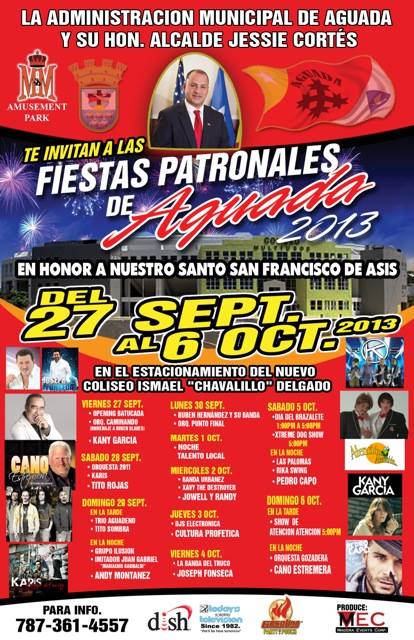
Aguada celebrates its patron saint festival in October. The Fiestas Patronales de San Francisco de Asis is a religious and cultural celebration in honor of Saint Francis of Assisi that generally features parades, games, artisans, amusement rides, regional food, and live entertainment.[4][58][59] The festival has featured live performances by well-known artists such as Kany García, Tito Rojas, Andy Montañez, and Cano Estremera.[60]
Other festivals and events celebrated in Aguada include:
Festival de Reyes (Three Kings Festival) which is celebrated in January at Paraíso de los Niños park. It is an activity dedicated to children of Aguada and is celebrated with gifts, music, clowns, and raffles.[4]
Festival de Playa (Beach Festival) is celebrated on June 24, the day of San Juan Bautista (Saint John the Baptist), at the Pico de Piedra Beach.
Festival y Feria de Artesanías (Arts & Craft Fair) takes place from November 17–20 at the Plaza Cristóbal Colón.[4]
Every year in November, a parade called La Parada del Descubrimento takes place to remember the discovery of Puerto Rico by Christopher Columbus. In this parade the people walk from the Catholic church in the town square to the Santurario Histórico a Colón (Cross of Columbus) next to the beach in Guaniquilla.[61]
Festival de Cabras de Raza is held on the last weekend of May in the Atalaya barrio, with exhibitions of different goat breeds and competitions.[4]
Parranda del Octavón is a one-day annual, cultural activity that takes place in January at the Plaza Cristóbal Colón, with local music.[4]
Encuentro de Talladores (Carvers' Meeting) is a one-day annual celebration that takes place the first weekend of July at the Plaza Cristóbal Colón, to commemorate the birthday of Don Zoilo Cajigas a carver of wooden saints. Carved wooden saints are on exhibition and for sale.[4]
Sports[edit]
Los Santeros de Aguada is the name of Aguada's current basketball team.[62]
Transportation[edit]
The main road leading to Aguada is PR-115, if you're coming from the north. If you're traveling from the south, you have to take PR-2.
There are 18 bridges in Aguada.[63]
Government[edit]
Mayors[edit]
All municipalities in Puerto Rico are administered by a mayor, elected every four years. The mayor of Aguada is Christian Cortes.[64]
This is a list of registered and known mayors of Aguada, until present time.[65]
| Years | Mayor | Political Party |
|---|---|---|
| 1921–1929 | Manuel Ruiz Gonzalez | |
| 1929–1933 | Carlos Gonzalez | |
| 1933–1937 | Efigenio Charneco | |
| 1937–1941 | Femando Rivera | |
| 1941–1945 | Andres Carrero | |
| 1945–1949 | Juan Villarrubia Santiago | PPD |
| 1949–1961 | Manuel Egipciaco | PPD |
| 1961–1969 | Juan Figueroa Gonzalez | PPD |
| 1969–1973 | Julio C. Roman Gonzalez (Yuyo) | PNP |
| 1973–1977 | Mabel Velez de Acevedo | PPD |
| 1977–2001 | Julio C. Roman Gonzalez (Yuyo) | PNP |
| 2001–2005 | Miguel A. Ruiz Hernandez (Miguelito) | PPD |
| 2005–2013 | Luis A. Echevarria Santiago (Berty) | PNP |
| 2013–2017 | Jessie Cortés Ramos | PPD |
| 2017–2021 | Manuel Gabina Santiago | PNP |
| 2021–present | Christian E. Cortés Feliciano | PPD |
Senate[edit]
The city belongs to the Puerto Rico Senatorial district IV of Mayagüez-Aguadilla, which is represented by two Senators.
House of Representatives[edit]
The city is represented in the 18th District which is represented by one representative.
Local Legislature[edit]
All municipalities have a local legislature.
Symbols[edit]
The municipio has an official flag and coat of arms.[66]
Flag[edit]
Aguada's flag was designed by Pedro Vélez Adróvar. It features three main colors: white, red, and yellow. White represents purity and the waters of Culebrinas River. Over the white field, a blue triangle with a white dove is featured. The dove is the symbol of peace that unites the towns. Red symbolizes the martyrdom of Franciscan friars from Espinal. Over the red field, there's a black cross which represents the birth of Christianity in Puerto Rico. The name of "Aguada" is also above the cross. The yellow field represents happiness and hospitality of the residents. Over the yellow field, there's a white star which symbolizes the hope of the town for more development and progress.[67][68]
Coat of Arms[edit]
The coat of arms is divided into two main fields. The upper field features a cross, with the interlaced arms of Christ and Father Saint Francis. It is taken from the badge of the Order of Friars Minor. It represents the motto "Pax et Bonum", which means "peace and good will between man and the Redeemer". The sun below the cross symbolizes the light that brightens the world. The lower part of the shield consists of five ships that symbolize the second voyage of Christopher Columbus, who allegedly arrived at the western "Guaniquilla" coast on November 19, 1493, to gather water. Although the precise location is disputed, the Aguada wells (Puerto de los pozos de la Aguada de Colón) is a plausible site for the actual event.[69][70]
The mural crown in the upper part of the shield signifies the title of village, that was given to this town by King Charles III in 1778. The official colors of the shield are red, which stands for the fraternal love in Aguada; gold, for the Spanish royalty in Puerto Rico; green, for the island's hope and fertility; black, for the wooden beam of the cross; blue, for the sky and the kingship of God; and white, for Christ's purity and the purity of the people of the town toward the cultural patrimony.[71][72]
Nicknames[edit]
Aguada has various nicknames, most of them pertaining to its origins. One is "La Villa del Sotomayor" ("Sotomayor Village"), which was the name originally given to it by Cristóbal de Sotomayor during its colonization in 1510. It is also called "Villa de San Francisco de Asís de la Aguada", which was the name given to the region when the Franciscan friars took control of it. Aguada is also called "La Ciudad del Descubrimiento" ("City of the Discovery") in reference to it being one of the possible places where Christopher Columbus entered the island. Other nicknames are "El Pueblo Playero" ("The Beach Town") for its many beaches, and "La Ciudad del Vaticano" ("The Vatican City") for being considered the "capital of Catholicism" in the island.[73][74]
Anthem[edit]
Aguada's anthem was written by Rolando Acevedo Lorenzo.[75]
Patron Saint[edit]
Saint Francis of Assisi is Aguada's patron saint.
Notable "Aguadeños"[edit]
- Ismael Miranda – Salsa Singer
- Guillermo "Willie" Hernandez – former Major League Baseball (MLB) pitcher and winner of the 1984 American League MVP and Cy Young Abarrios.
- Andrés Torres – Major League Baseball (MLB) player (San Francisco Giants)
- Zoilo Cajigas Sotomayor – Wood carving artist, especially religious figurines
Gallery[edit]
-
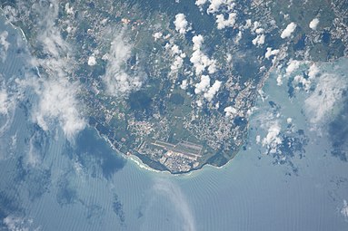 Photo shows Aguada, Aguadilla and Isabela taken from the ISS Expedition 53
 -
 Remains of the Coloso sugarmill in Aguada

See also[edit]
- List of Puerto Ricans
- History of Puerto Rico
- National Register of Historic Places listings in Aguada, Puerto Rico
References[edit]
- ^ Aguada: Founding and History. Archived February 14, 2019, at the Wayback Machine Accessed September 10, 2019.
- ^ Bureau, US Census. "PUERTO RICO: 2020 Census". The United States Census Bureau. Archived from the original on December 1, 2021. Retrieved August 25, 2021.
- ^ "Aguada, Puerto Rico – La Villa de Sotomayor". BoricuaOnline.com (in European Spanish). November 26, 2016. Archived from the original on October 7, 2021. Retrieved October 7, 2021.
- ^ a b c d e f g "AGUADA – ¡LA VILLA DE SOTOMAYOR!" (PDF). aguada.gov.pr (in Spanish). PR Government. Archived (PDF) from the original on September 21, 2018. Retrieved June 16, 2020.
- ^ Caciques y Yucayeques de Puerto Rico Archived November 7, 2012, at the Wayback Machine on Proyecto Salon Hogar
- ^ Van Middeldyk, R.A. (1903). The history of Puerto Rico, from the Spanish discovery to the American occupation. NY: D. Appleton and Co. p. 13-16.
- ^ Morison, Samuel Eliot (1986). The Great Explorers: The European Discovery of America. Oxford University Press. pp. 440, 448, 449. ISBN 978-0-19-504222-1.
- ^ "Controversia en Puerto Rico por el punto donde Colón llegó a la isla caribeña". Diario Libre (in Spanish). December 6, 2019. Retrieved January 19, 2024.
- ^ Fuson, Robert (2000). Juan Ponce De Leon and the Spanish Discovery of Puerto Rico and Florida. Blacksburg, Virginia: McDonald & Woodward. p. 79. ISBN 0-939923-82-3.
- ^ a b Aguada, la Villa del Sotomayor Archived July 17, 2014, at the Wayback Machine on Proyecto Salon Hogar
- ^ Menhinick, Kevin, "The Caribs in Dominica" Archived March 3, 2012, at the Wayback Machine
- ^ Puerto Rico. Office of Historian (1949). Tesauro de datos historicos: indice compendioso de la literatura histórica de Puerto Rico, incluyendo algunos datos inéditos, periodísticos y cartográficos (in Spanish). Impr. del Gobierno de Puerto Rico. p. 238. Archived from the original on August 14, 2023. Retrieved January 4, 2020.
- ^ Mari Mut, José A. (August 28, 2013). "Los pueblos de Puerto Rico y las iglesias de sus plazas" (in Spanish). Retrieved June 23, 2020 – via archive.org.
- ^ "Aguada Municipality". Enciclopedia PR. Archived from the original on February 14, 2019. Retrieved February 14, 2019.
- ^ Aguada: Fundación e historia Archived July 1, 2014, at the Wayback Machine on Enciclopedia de Puerto Rico
- ^ Tsunamis in the Caribbean Sea – NOAA[permanent dead link]
- ^ "Preliminary Locations of Landslide Impacts from Hurricane Maria, Puerto Rico". USGS Landslide Hazards Program. USGS. Archived from the original on March 3, 2019. Retrieved March 3, 2019.
- ^ "Preliminary Locations of Landslide Impacts from Hurricane Maria, Puerto Rico" (PDF). USGS Landslide Hazards Program. USGS. Archived (PDF) from the original on March 3, 2019. Retrieved March 3, 2019.
- ^ "María, un nombre que no vamos a olvidar – Aguada" [Maria, a name we will never forget – Aguada]. El Nuevo Día (in Spanish). June 13, 2019. Archived from the original on August 24, 2021. Retrieved August 24, 2021.
- ^ PR • •, Por TELEMUNDO (July 17, 2023). "Vientos de 110mph: catalogan como EF-1 el tornado en Aguada". Telemundo Puerto Rico (in Spanish). Retrieved January 19, 2024.
- ^ "Selección de Leyendas puertorriqueñas – El Matador de Tiburones (1640)". ufdc (in Spanish). p. 27. Archived from the original on March 6, 2019. Retrieved March 4, 2019.
- ^ a b c Aguada Archived June 17, 2012, at the Wayback Machine on Enciclopedia de Puerto Rico
- ^ a b "Aguada Municipality General Info (Location, Square Miles, Economy and Geography)". enciclopediapr. Fundación Puertorriqueña de las Humanidades (FPH). Archived from the original on February 14, 2019. Retrieved February 14, 2019.
- ^ Aguada Archived October 8, 2011, at the Wayback Machine on SalonHogar.com
- ^ "Las 1,200 playas de Puerto Rico [The 1200 beaches of Puerto Rico]". Primera Hora (in Spanish). April 14, 2017. Archived from the original on December 12, 2019. Retrieved December 12, 2019.
- ^ "EPA Municipio Aguada Discharges" (PDF). Archived (PDF) from the original on August 5, 2018. Retrieved August 5, 2018.
- ^ Picó, Rafael; Buitrago de Santiago, Zayda; Berrios, Hector H. (September 5, 1969). Nueva geografía de Puerto Rico: física, económica, y social, por Rafael Picó. Con la colaboración de Zayda Buitrago de Santiago y Héctor H. Berrios. San Juan Editorial Universitaria, Universidad de Puerto Rico,1969. Archived from the original on December 26, 2018. Retrieved January 13, 2019.
- ^ Gwillim Law (May 20, 2015). Administrative Subdivisions of Countries: A Comprehensive World Reference, 1900 through 1998. McFarland. p. 300. ISBN 978-1-4766-0447-3. Retrieved December 25, 2018.
- ^ a b Puerto Rico:2010:population and housing unit counts.pdf (PDF). U.S. Dept. of Commerce, Economics and Statistics Administration, U.S. Census Bureau. 2010. Archived (PDF) from the original on February 20, 2017. Retrieved January 13, 2019.
- ^ "Map of Aguada" (PDF). Archived from the original (PDF) on April 17, 2015. Retrieved December 29, 2018.
- ^ "US Census Barrio-Pueblo definition". factfinder.com. US Census. Archived from the original on May 13, 2017. Retrieved January 5, 2019.
- ^ "DESGLOSE DE SECTORES Y CENTROS DE VOTACIÓN PRECINTO ELECTORAL – AGUADA 038" (PDF). Comisión Estatal de Elecciones Puerto Rico (in Spanish). October 28, 2019. Archived (PDF) from the original on June 16, 2020. Retrieved June 16, 2020.
- ^ "En 23 meses se han invertido $4.3 millones en asfalto: Aguada anuncia la tercera parte de Operación Brea". El Foro de Puerto Rico. January 24, 2023. Archived from the original on February 6, 2023. Retrieved March 28, 2023.
- ^ Rivera Quintero, Marcia (2014), El vuelo de la esperanza:Proyecto de las Comunidades Especiales Puerto Rico, 1997–2004 (Primera edición ed.), San Juan, Puerto Rico Fundación Sila M. Calderón, p. 273, ISBN 978-0-9820806-1-0
- ^ "NOWData - NOAA Online Weather Data". National Oceanic and Atmospheric Administration. Retrieved April 8, 2024.
- ^ "Summary of Monthly Normals 1991-2020". National Oceanic and Atmospheric Administration. Retrieved April 8, 2024.
- ^ "U.S. Decennial Census". United States Census Bureau. Archived from the original on February 13, 2020. Retrieved September 21, 2017.
- ^ "Report of the Census of Porto Rico 1899". War Department, Office Director Census of Porto Rico. Archived from the original on July 16, 2017. Retrieved September 21, 2017.
- ^ "Table 3-Population of Municipalities: 1930, 1920, and 1910" (PDF). United States Census Bureau. Archived (PDF) from the original on August 17, 2017. Retrieved September 21, 2017.
- ^ "Table 4-Area and Population of Municipalities, Urban and Rural: 1930 to 1950" (PDF). United States Census Bureau. Archived (PDF) from the original on August 30, 2015. Retrieved September 21, 2014.
- ^ "Table 2 Population and Housing Units: 1960 to 2000" (PDF). United States Census Bureau. Archived (PDF) from the original on July 24, 2017. Retrieved September 21, 2017.
- ^ Bureau, US Census. "PUERTO RICO: 2020 Census". The United States Census Bureau. Archived from the original on December 1, 2021. Retrieved August 25, 2021.
- ^ "Population and Housing Unit Estimates". United States Census Bureau. Archived from the original on December 27, 1996. Retrieved September 21, 2017.
- ^ Bureau, U. S. Census. "American FactFinder – Results". factfinder. Archived from the original on November 20, 2015. Retrieved March 4, 2019.
- ^ Censo 2000: Población de Puerto Rico por Municipios y Barrios Archived July 2, 2014, at the Wayback Machine on CEEPUR
- ^ "Población de Puerto Rico por Municipios: 1930–2000". CEEPUR. Archived from the original on March 21, 2013.
- ^ "2010 Census Interactive Population Search: Aguada, Puerto Rico". US Census 2010. Archived from the original on July 27, 2013.
- ^ Central Coloso Archived July 8, 2012, at the Wayback Machine on Enciclopedia de Puerto Rico
- ^ González González, Eugenio (1962). Memoria Histórica de Aguada (in Spanish) (1st ed.). Rio Piedras, PR: Imprenta America, Inc. p. 125.
- ^ "De camino el contrato para el proyecto de caña". El Nuevo Dia. January 1, 2015. Archived from the original on January 1, 2015. Retrieved January 21, 2022.
- ^ Ruinas de la Ermita Espinar Archived October 6, 2012, at the Wayback Machine on Travel and Sports
- ^ Porta del Sol – Pueblos Archived June 5, 2012, at the Wayback Machine on Porta del Sol
- ^ Pasaporte: Voy Turisteando (in Spanish). Compañia de Turismo de Puerto Rico. 2021.
- ^ "Patrimonio Volumen IV". Issuu (in Spanish). August 23, 2018. Archived from the original on February 27, 2023. Retrieved April 10, 2021.
- ^ "Puerto Rico: Registro Nacional de Lugares Históricos" (PDF). geoisla.com. Government of Puerto Rico. Archived (PDF) from the original on May 15, 2021. Retrieved May 15, 2021.
- ^ "Directorio Comprensivo de Escuelas Públicas, Puerto Rico 2018 | Puerto Rico Government Open Data Portal". data.pr.gov. Archived from the original on October 4, 2018. Retrieved March 28, 2020.
- ^ "Search for Public Schools". nces.ed.gov. Archived from the original on April 17, 2020. Retrieved March 29, 2020.
- ^ "Puerto Rico Festivales, Eventos y Actividades en Puerto Rico". Puerto Rico Hoteles y Paradores (in Spanish). Archived from the original on February 26, 2020. Retrieved July 17, 2020.
- ^ "LinkToPuertoRico.com – Aguada" (in Spanish). Proyecto Salon Hogar. Archived from the original on July 17, 2014. Retrieved December 27, 2017.
- ^ "Fiestas Patronales de Aguada 2013 en honor a Santo San Francisco de Asis". sondeaquiprnet. El Gobierno Municipal de Aguada. Archived from the original on July 3, 2022. Retrieved August 14, 2023.
- ^ "Aguada celebra sus 500 años". El Nuevo Día (in Spanish). November 21, 2010. Archived from the original on January 22, 2013.
- ^ "Bayamón y Aguada comandan en el inicio de los cuartos de final". El Vocero de Puerto Rico. September 6, 2019. Archived from the original on August 14, 2023. Retrieved June 10, 2019.
- ^ "Aguada Bridges". National Bridge Inventory Data. US Dept. of Transportation. Archived from the original on February 20, 2019. Retrieved February 19, 2019.
- ^ "Nuevos alcaldes del oeste coordinan con la guardia nacional vacunación y clases". Periodico Visión (in Spanish). December 15, 2015. Archived from the original on January 13, 2021. Retrieved January 11, 2021.
- ^ Aguada... la Villa de Sotomayor Archived July 17, 2014, at the Wayback Machine on ProyectoSalonHogar
- ^ "Ley Núm. 70 de 2006 -Ley para disponer la oficialidad de la bandera y el escudo de los setenta y ocho (78) municipios". LexJuris de Puerto Rico (in Spanish). Archived from the original on January 20, 2021. Retrieved June 15, 2021.
- ^ Bandera de Aguada Archived January 6, 2012, at the Wayback Machine on Aguada Official website
- ^ "AGUADA". LexJuris (Leyes y Jurisprudencia) de Puerto Rico (in Spanish). February 19, 2020. Archived from the original on February 19, 2020. Retrieved September 16, 2020.
- ^ "AGUADA – ¡LA VILLA DE SOTOMAYOR!" (PDF). aguada.gov.pr. Government of Aguada, Puerto Rico. Archived (PDF) from the original on September 21, 2018. Retrieved January 21, 2022.
- ^ "Aguada: un manantial de historia". Primera Hora (in Spanish). October 5, 2021. Archived from the original on January 21, 2022. Retrieved January 21, 2022.
- ^ "Banderas y escudos municipales" (Flags and Municipal Shields) by Anisa Productions Inc.
- ^ Escudo de Aguada Archived October 4, 2015, at the Wayback Machine on Aguada Official website
- ^ Aguada Archived April 16, 2009, at the Wayback Machine on FiliRealty
- ^ "Directorio de Municipios de Puerto Rico". pr.gov. Archived from the original on March 15, 2019. Retrieved March 15, 2019.
- ^ Aguada Archived October 8, 2011, at the Wayback Machine on Salon Hogar
Further reading[edit]
- Mapa de municipios y barrios - Aguada - Memoria Núm. 55 (PDF). University of Puerto Rico: Estado Libre Asociado de Puerto Rico, Oficina del Gobernador, Junta de Planificacion, Santurce, Puerto Rico. 1955.
External links[edit]
- Puerto Rico Government Directory – Aguada Archived January 29, 2023, at the Wayback Machine
- Aguada Municipality Brochure (Spanish)
- Proyecto Salón Hogar sobre Aguada (Spanish)
- Photos of Aguada
- Aguada Municipality on Facebook
Places adjacent to Aguada, Puerto Rico | ||||||||||||||||
|---|---|---|---|---|---|---|---|---|---|---|---|---|---|---|---|---|
| ||||||||||||||||
| International | |
|---|---|
| National | |
| Geographic | |