
Drimmelen
Drimmelen | |
|---|---|
 Aerial photo of Made | |
 Flag | |
.svg) Location in North Brabant | |
| Coordinates: 51°41′N 4°48′E / 51.683°N 4.800°E | |
| Country | Netherlands |
| Province | North Brabant |
| Government | |
| • Body | Municipal council |
| • Mayor | Gert de Kok (PvdA) |
| Area | |
| • Total | 119.43 km2 (46.11 sq mi) |
| • Land | 95.18 km2 (36.75 sq mi) |
| • Water | 24.25 km2 (9.36 sq mi) |
| Elevation | 3 m (10 ft) |
| Population (January 2021)[4] | |
| • Total | 27,325 |
| • Density | 287/km2 (740/sq mi) |
| Time zone | UTC+1 (CET) |
| • Summer (DST) | UTC+2 (CEST) |
| Postcode | 4844–4845, 4920–4927 |
| Area code | 0162 |
| Website | www |
Drimmelen (Dutch pronunciation: [ˈdrɪmələ(n)] ⓘ) is a municipality and a town in the southern Netherlands, in the province North Brabant.
A large portion of the Biesbosch National Park is part of this municipality.
Population centres[edit]
Towns:
- Made (population: 11,710)
- Terheijden (6,410)
- Lage Zwaluwe (4,060)
- Wagenberg (2,250)
- Hooge Zwaluwe (1,670)
- Drimmelen (570)
Hamlets (population data concerning these hamlets are included in the population data of the towns near which they are located):
- Blauwe Sluis
- Oud-Drimmelen
- Helkant
Topography[edit]

Dutch Topographic map of the municipality of Drimmelen, June 2015.
Transportation[edit]
The Lage Zwaluwe railway station is situated on the Breda–Rotterdam railway and the railway to Roosendaal.
Notable people[edit]

- Godfried Schalcken (1643 in Made – 1706) a Dutch genre and portrait painter
- Pieter Rudolph Kleijn (1785 in Hooge Zwaluwe – 1816) a 19th-century landscape painter
- Petrus van Schendel (1806 in Terheijden - 1870) a Dutch-Belgian Romantic style genre painter
- Johannes Gijsbert Vogel (1828 in Hooge Zwaluwe – 1915) a Dutch landscape painter
- Antal van den Bosch (born 1969 in Made) a Dutch-language researcher and former academic
Sport[edit]
- Kees Pellenaars (1913 in Terheijden – 1988) a Dutch road cyclist and coach
- Antoon van Schendel (1918 in Lage Zwaluwe — 1990) a Dutch professional road bicycle racer.
- Wim Hofkens (born 1958 in Made) a former football player with 474 club caps
- Gianni Romme (born 1973 in Lage Zwaluwe) a Dutch marathon runner and a former long track speed skater, won two gold medals at the 1998 Winter Olympics
- Hans Horrevoets (born 1974 in Made – 2006) a Dutch sea sailor
- Tim Lips (born 1985 in Made) a Dutch eventer, competed at the 2008 and the 2012 Summer Olympics
- Pieter Braun (born 1993 in Terheijden) is a Dutch decathlon athlete, competed at the 2016 Summer Olympics
Gallery[edit]
-
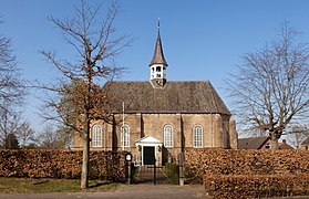 Made, reformed church
 -
 Jachthaven, Drimmelen
 -
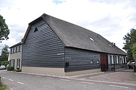 Woonhuis met bedrijfsgedeelte, Bloemendaalse Zeedijk 40, Blauwe Sluis
 -
 Zilvermeeuw, Drimmelen


References[edit]
- ^ "Collegeleden" [Board members] (in Dutch). Gemeente Drimmelen. Retrieved 10 May 2014.
- ^ "Kerncijfers wijken en buurten 2020" [Key figures for neighbourhoods 2020]. StatLine (in Dutch). CBS. 24 July 2020. Retrieved 19 September 2020.
- ^ "Postcodetool for 4921BV". Actueel Hoogtebestand Nederland (in Dutch). Het Waterschapshuis. Retrieved 11 May 2014.
- ^ "Bevolkingsontwikkeling; regio per maand" [Population growth; regions per month]. CBS Statline (in Dutch). CBS. 1 January 2021. Retrieved 2 January 2022.
External links[edit]
Wikimedia Commons has media related to Drimmelen.
Places adjacent to Drimmelen | ||||||||||||||||
|---|---|---|---|---|---|---|---|---|---|---|---|---|---|---|---|---|
| ||||||||||||||||

| International | |
|---|---|
| National | |
This North Brabant location article is a stub. You can help Wikipedia by expanding it. |