
Veldhoven
Veldhoven | |
|---|---|
 Church in Veldhoven | |
 Flag  Coat of arms | |
.svg) Location in North Brabant | |
| Coordinates: 51°25′12″N 05°24′18″E / 51.42000°N 5.40500°E | |
| Country | Netherlands |
| Province | North Brabant |
| Government | |
| • Body | Municipal council |
| • Mayor | Marcel Delhez (VVD) |
| Area | |
| • Total | 31.89 km2 (12.31 sq mi) |
| • Land | 31.69 km2 (12.24 sq mi) |
| • Water | 0.20 km2 (0.08 sq mi) |
| Elevation | 22 m (72 ft) |
| Population (January 2021)[4] | |
| • Total | 45,500 |
| • Density | 1,436/km2 (3,720/sq mi) |
| Demonym | Veldhovenaar |
| Time zone | UTC+1 (CET) |
| • Summer (DST) | UTC+2 (CEST) |
| Postcode | 5500–5509 |
| Area code | 040 |
| Website | www |
Veldhoven (Dutch pronunciation: [ˈvɛltˌɦoːvə(n)] ⓘ) is a municipality and town on the Gender in the southern Netherlands, just southwest of Eindhoven.
Topography[edit]

Dutch topographic map of Veldhoven (town), Dec. 2013
Population centres[edit]
The modern town of Veldhoven is an agglomeration of formerly rural villages that in the twentieth century grew together to form one large suburban area catering to Eindhoven commuter needs. The villages are Veldhoven proper to the southwest, Meerveldhoven to the southeast, Oerle to the west and Zeelst to the northeast. A new city center was constructed between Zeelst and Veldhoven.
Economy[edit]
Veldhoven is home to the headquarters of the manufacturer of high-tech (semiconductor) lithography equipment ASML. As of 2022, the company employs over 14,000 people—equivalent to nearly one third of the town's population.[5] ASML occupies the tallest building (83 meters) in Veldhoven. The municipality features a large industrial and office area along the Gender, which also includes the second-largest hospital in the Eindhoven urban region, Máxima Medisch Centrum.
Veldhoven Centrum[edit]
Veldhoven Centrum has 113 commercial shops with famous brands covering food restaurants, daily groceries, fashion products, Jewelry and banks. The Centrum has services such as Library Veldhoven, Municipality of Veldhoven, Trigion security City and VVV Veldhoven. The Veldhoven shops open at 11 AM every Monday. The Centrum has Week Market every Monday for fruit and produce.
Culture[edit]
The yearly festival Cult en Tumult offers a varied program of art and culture in the broadest sense. Theatre De Schalm is near the City Centrum.
The spoken language is Kempenlands (an East Brabantian dialect, which is very similar to colloquial Dutch).[6]
Town council[edit]
The current town council of Veldhoven was elected at the Dutch 2018 local elections.
| Council seats[7][8][9][10] | |||||
|---|---|---|---|---|---|
| Party | 1998 | 2002 | 2006 | 2010 | 2014 |
| VSA | 5 | 8 | 8 | 7 | 6 |
| GBV | 3 | 5 | 4 | 5 | 6 |
| VVD | 5 | 4 | 4 | 5 | 5 |
| CDA | 7 | 7 | 5 | 4 | 4 |
| D66 | 1 | 0 | 0 | 2 | 3 |
| PvdA | 3 | 3 | 6 | 3 | 2 |
| Samenwerkend Veldhoven | 0 | 0 | 0 | 1 | 1 |
| SP | 3 | 0 | 0 | 0 | 0 |
| Total | 27 | 27 | 27 | 27 | 27 |
Transport[edit]
Eindhoven Airport is near Veldhoven, on the border with Eindhoven in Meerhoven, close to the A2 and A67 motorways.
Notable people[edit]

- Willem Adams (born 1937 in Veldhoven) a Dutch painter
- Jan Cornelius van Sambeek (1886 in Veldhoven - 1966 in Kabanga) a Dutch White Fathers missionary in Tanganyika
- Marius van Amelsvoort (1930 – 2006 in Veldhoven) a Dutch politician and diplomat
- Hendricus Stoof (born 1962 in Veldhoven) a professor of theoretical physics at Utrecht University
- Henrieke Goorhuis (born 1990 in Veldhoven) a Dutch cartoonist and illustrator
- Raoul van Grinsven (born 1974) stage name DJ Zany, a disc jockey, owns Fusion Records, lives in Veldhoven
- Anita Groener (born 1958 in Veldhoven) a Dutch artist
- Mau Heymans (born 1961 in Veldhoven) a Dutch Disney comics artist and writer
- Jessy Seuntiens (born 1980 in Oerle) stage name Jesselyn, is a Dutch DJ
- Daan de Kort (born 1992 in Veldhoven) a Dutch politician
- Tiny Kox (born 1951 in Veldhoven) a Dutch politician
- Teun Luijkx (born 1986 in Veldhoven) a Dutch actor[11]
- Maartje Verhoef (born 1997 in Veldhoven) a Dutch fashion model
Sport[edit]

- John van den Akker (born 1966 in Veldhoven) a Dutch former cyclist
- Rob van Boekel (born 1987 in Veldhoven) a Dutch footballer
- Kayleigh van Dooren (born 1987 in Veldhoven) a Dutch footballer
- Gerard Egelmeers (born 1999 in Veldhoven) a former Olympic rower
- Toon Geurts (1932 in Veldhoven – 2017) a Dutch sprint canoer, silver medallist at the 1964 Summer Olympics
- Eelco Horsten (born 1989 in Veldhoven) a Dutch footballer
- Maud Kaptheijns (born 1994 in Veldhoven) a Dutch cyclist
- Corné van Kessel (born 1991 in Veldhoven) a Dutch professional cyclo-cross and road cyclist
- Paco van Moorsel (born 1989 in Veldhoven) a Dutch footballer with 280 club caps
- Milou van der Heijden (born 1990 in Veldhoven) a professional squash player
Gallery[edit]
-
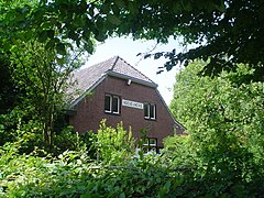 Hoeve 't Heike - Veldhoven
 -
 former Sint Maartenkerk - Veldhoven
 -
 Drie Muzikanten - Veldhoven
 -
 Gemeentehuis - Veldhoven
 -
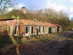 Boerderij Kleine Vliet - Oerle


See also[edit]
References[edit]
- ^ "Burgemeester" [Mayor] (in Dutch). Gemeente Veldhoven. Archived from the original on 6 June 2014. Retrieved 6 June 2014.
- ^ "Kerncijfers wijken en buurten 2020" [Key figures for neighbourhoods 2020]. StatLine (in Dutch). CBS. 24 July 2020. Retrieved 19 September 2020.
- ^ "Postcodetool for 5501KA". Actueel Hoogtebestand Nederland (in Dutch). Het Waterschapshuis. Archived from the original on 21 September 2013. Retrieved 6 June 2014.
- ^ "Bevolkingsontwikkeling; regio per maand" [Population growth; regions per month]. CBS Statline (in Dutch). CBS. 1 January 2021. Retrieved 2 January 2022.
- ^ Baazil, Diederik; Roach, April (14 November 2022). "European Tech Giant's Expansion Stirs Opposition in Its Hometown". Bloomberg News.
- ^ Jos & Cor Swanenberg: Taal in stad en land: Oost-Brabants, ISBN 9012090105
- ^ NRC Handelsblad (2002) Gemeenteraadsverkiezingen 6 maart 2002 Veldhoven Archived 2005-06-10 at the Wayback Machine
- ^ Gemeente Veldhoven (2006) Uitslag verkiezingen Archived 2008-09-08 at the Wayback Machine
- ^ Volkskrant (2010)Uitslagen verkiezingen Gemeenteraad 2010
- ^ Website Veldhoven (2014)Uitslagen verkiezingen Gemeenteraad 2014
- ^ IMDb Database Archived 2019-09-08 at the Wayback Machine retrieved 24 December 2019
External links[edit]
 Media related to Veldhoven at Wikimedia Commons
- Official website

| International | |
|---|---|
| National | |
| Geographic | |