Setonaikai National Park
| Setonaikai National Park | |
|---|---|
| 瀬戸内海国立公園 | |
 | |
| Location | Seto Inland Sea, Japan |
| Area | 669.34 km² |
| Established | March 16, 1934[1] |
Setonaikai National Park (瀬戸内海国立公園, Setonaikai Kokuritsu Kōen) is a national park comprising areas of Japan's Inland Sea and of ten bordering Prefectures. Designated a national park in 1934, it has since been expanded several times. It contains about 3,000 islands, including the well-known Itsukushima. Formed of many non-contiguous areas, and covering a tiny proportion of the Inland Sea's total extent, control and protection is problematic, with much of the wider area heavily industrialized.[2][3]
Natural Areas
- Islands: Awaji Island (part), Bōyo Islands, Ieshima, Miyajima, Naoshima, Shiwaku Islands, Shōdoshima, Tomogashima
- Mountains: Mount Rokkō, Mount Maya, Mount Noro
- Straits: Akashi Strait, Hōyo Strait, Kitan Strait, Naruto Strait, Kanmon Straits
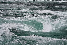
- Other: Naruto whirlpools[4]
Cultural Sites
Related Municipalities
The park crosses the borders of fifty-five cities, fourteen towns, and one village:[1]
- Ehime: Ikata, Imabari, Kamijima, Matsuyama, Ōzu, Saijō, Yawatahama
- Fukuoka: Kitakyushu
- Hiroshima: Etajima, Fukuyama, Hatsukaichi, Higashihiroshima, Hiroshima, Kure, Mihare, Onomichi, Ōsakikamijima, Ōtake, Saka, Takehara
- Hyōgo: Aioi, Akashi, Akō, Ashiya, Awaji, Himeji, Kobe, Minamiawaji, Nishinomiya, Sumoto, Takarazuka, Tatsuno
- Kagawa: Higashikagawa, Kan'onji, Kotohira, Mannō, Marugame, Mitoyo, Naoshima, Sakaide, Sanuki, Shōdoshima, Tadotsu, Takamatsu, Tonoshō, Zentsūji
- Ōita: Bungotakada, Himeshima, Kunisaki, Ōita
- Okayama: Asakuchi, Bizen, Kasaoka, Kurashiki, Okayama, Setouchi, Tamano
- Tokushima: Naruto
- Wakayama: Wakayama
- Yamaguchi: Hikari, Hirao, Hōfu, Iwakuni, Kaminoseki, Kudamatsu, Shimonoseki, Shūnan, Suō-Ōshima, Tabuse, Yanai
See also
Wikimedia Commons has media related to Setonaikai National Park.
References
- ^ a b "Setonaikai National Park - Basic Information". Ministry of the Environment. Retrieved 1 February 2012.
- ^ "Setonaikai National Park". Ministry of the Environment. Retrieved 1 February 2012.
- ^ Sutherland, Mary; Britton, Dorothy (1995). National Parks of Japan. Kodansha. pp. 125–7.
- ^ a b "Introducing places of interest: Setonaikai National Park". Ministry of the Environment. Retrieved 1 February 2012.
External links
Categories:
- IUCN Category II
- National parks of Japan
- Parks and gardens in Ehime Prefecture
- Parks and gardens in Ōita Prefecture
- Parks and gardens in Hiroshima Prefecture
- Parks and gardens in Kagawa Prefecture
- Parks and gardens in Hyōgo Prefecture
- Parks and gardens in Wakayama Prefecture
- Parks and gardens in Okayama Prefecture
- Parks and gardens in Yamaguchi Prefecture
- Parks and gardens in Tokushima Prefecture
- Parks and gardens in Fukuoka Prefecture
- Protected areas established in 1934

