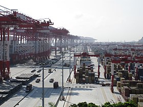
Yangshan Port
| Yangshan Port | |
|---|---|
 Yangshan Port | |
 Click on the map for a fullscreen view | |
| Location | |
| Country | China |
| Location | Shengsi County, Zhejiang Province |
| Coordinates | 30°37′N 122°04′E / 30.617°N 122.067°E |
| Details | |
| Opened | 2005 |
| Operated by | Shanghai International Port Group |
| Type of harbour | Deep-water seaport |
| Statistics | |
| Annual container volume | > 10 million TEU (2010) |
Yangshan Port (Chinese: 洋山港, p Yángshān Gǎng, Wu Yan-se Kaon), formally the Yangshan Deep-Water Port (洋山深水港, p Yángshān Shēnshuǐ Gǎng, Wu Yan-se Sen-sy Kaon), is a deep water port for container ships in Hangzhou Bay south of Shanghai. Connected to Shanghai's Pudong New Area by the Donghai Bridge and forming part of the Port of Shanghai, the islands of Greater and Lesser Yangshan are administered separately as part of Zhejiang's Shengsi County.
Built to allow the Port of Shanghai to grow despite shallow waters near the shore, it allows berths with depths of up to 15 metres (49 ft) to be built, and can handle today's largest container ships. The port is built on the islands of Greater and Lesser Yangshan, part of the Zhoushan archipelago, with fill from land reclamation. In 2019, the port handled 43.35 million TEU. In 2015, the port handled 36.54 million Twenty-foot equivalent unit (TEU) up 3.5% over 2014.[1] In 2013 the volume was 33.6 million TEU.[2] In mid-2011, port officials said the port was on track to move 12.3 million TEUs during the year, up from 10.1 million TEUs in 2010.[3] The port is part of the Maritime Silk Road.[4][5]
Construction phases
In 2000 and 2001, the decision was made to commence construction on the first of four phases. The first two phases have nine berths in total along a 3 km (1.9 mi) quayside. The first phase, which opened in 2004, can accommodate 2.2 million containers annually and includes 10 quay cranes. The second phase was opened in December 2006, and comprises 72 hectares (180 acres) with 15 quay cranes. The third phase, opened in stages, was completed in 2010 with seven berths.[citation needed] The fourth phase, which began trial operation on Dec. 10, 2017,[6] will add 4 million TEUs to the port's annual capacity.[3]
The total cost of building the port may reach US$12 billion over 20 years.[7] When complete, the port will have 30 berths capable of handling 15 million TEUs annually.[8]
Highway access
The Yangshan Port is connected to the mainland via the 32.5 km (20.2 mi) Donghai Bridge, opened on 1 December 2005 as the world's longest sea bridge. The six-lane highway bridge took 6,000 workers two and half years to construct.[9]
Rail access
There is no direct railway connection to the Yangshan Port. The port is served by Luchaogang railway station (芦潮港站; 30°52′46″N 121°51′27″E / 30.879414°N 121.857443°E) of the Pudong Railway (浦东铁路), which was opened in 2005 near the mainland end of the Donghai Bridge.[10]
See also
References
- ^ http://www.simic.net.cn/news_list.php?lan=en&id=368&flag=cnports&pname=shanghai
- ^ http://www.china-briefing.com/news/2014/09/17/logistics-shanghai-free-trade-zone.html
- ^ a b "Yangshan Deep-water port's TEU traffic may climb to 12.3 million". Marine News China. 24 June 2011. Retrieved July 15, 2011.
- ^ Yangshan City Port. The world’s biggest container port opens new Silk Road for shipping
- ^ AJOT’s top 100 container ports
- ^ [1]
- ^ [2]
- ^ "PSA, China Shipping hold share". China Daily. January 26, 2007. Retrieved July 15, 2011.
- ^ Barbosa, David (December 11, 2005). "Shanghai opens new shipping port". New York Times. Retrieved July 15, 2011.
- ^ 洋山深水港配套工程浦东铁路将发首趟集装箱专列 (Pudong Railway, supporting the Yangshan Port, will send the first container train), 2005-12-09
External links
- National Geographic: Megastructures has an episode about the port
