
Canton Viaduct: Difference between revisions
→Inception: added engineers |
→Inception: added ranks |
||
| Line 125: | Line 125: | ||
[[Image:Canton Viaduct Model-Deck and Dirt Removed.jpg|thumb|left|Model of wall section with deck and dirt removed.]] |
[[Image:Canton Viaduct Model-Deck and Dirt Removed.jpg|thumb|left|Model of wall section with deck and dirt removed.]] |
||
The Canton Viaduct was erected in 1835 by the B&P, one of the first New England railroads, shortly after its 1831 founding. Thomas B. Wales, from one of the founding families of Boston, and owner of the T.B. Wales & Co. shipping company, was the first president of the B&P. Due to his friendship with prominent New England families, including the Revere family, he was able to bring the B&P to fruition. The T.B. Wales & Co. clipper ships brought raw materials for manufacturing companies from its docks (Wales Wharf and Long Wharf) to various areas in New England. Without the influence of individuals such as Thomas B. Wales, Joseph Warren Revere, owner of the [[Revere Copper Company]] and major stockholders (whom most were Board members), the Canton Viaduct would not have been built. There were better routes through other towns for the location of the railroad line from Boston to Providence. However, building the railroad through Canton placed the line close to Revere's mill, where a half mile [[spur line|spur]] (using [[Rail profile|strap rails]] and horse power) connected the mill to Canton Junction and undoubtedly gave a boost to Revere's copper business. The other influencing factor that caused the Canton Viaduct to be built was a fatal accident in 1832 on the [[Granite Railroad]], which used inclined planes to cross a valley.<ref>[[:File:Granite Railway - General view of incline to Quarry from Northwest.jpg|Plan of the Granite Railroad inclined planes]]</ref> The original plans called for the use of inclined planes to cross the Canton River Valley but were changed after the inclined plane accident and a bridge was built instead. This unique bridge was designed by a US Army Corps of Engineer officer - Captain [http://americanhistory.si.edu/westpoint/history_2b1.html# William Gibbs McNeill] a [[West Point]] graduate; he was assisted by other West Point engineers, Major [[George Washington Whistler]] (McNeill's brother-in law), [[Isaac Ridgeway Trimble]] and [http://books.google.com/books?id=31wSAAAAYAAJ&pg=PA28&lpg=PA28&dq=william+raymond+lee+providence+railroad&source=bl&ots=r3ldIDLMn0&sig=nwXWJD_zjgbuhXKJRG1KIW-5KIU&hl=en&ei=AkoBS8idJMaAnQffl4WNCw&sa=X&oi=book_result&ct=result&resnum=1&ved=0CAoQ6AEwAA#v=onepage&q=william%20raymond%20lee%20providence%20railroad&f=false William Raymond Lee]. The bridge was built by [[Dodd & Baldwin]] (Pennsylvania). Around this time Russia was interested in building railroads so Tsar Nicholas I sent workmen to draw extensive diagrams of the Canton Viaduct. He later summoned Whistler to Russia as a consulting engineer to design the [[Moscow–Saint Petersburg Railway]], on which two bridges were modeled after the Canton Viaduct. A [[:File:Russian Canton Viaduct.jpg|scale model]] bridge of similar design is on display at the Oktyabrsky Railroad Museum in St. Petersburg. |
The Canton Viaduct was erected in 1835 by the B&P, one of the first New England railroads, shortly after its 1831 founding. Thomas B. Wales, from one of the founding families of Boston, and owner of the T.B. Wales & Co. shipping company, was the first president of the B&P. Due to his friendship with prominent New England families, including the Revere family, he was able to bring the B&P to fruition. The T.B. Wales & Co. clipper ships brought raw materials for manufacturing companies from its docks (Wales Wharf and Long Wharf) to various areas in New England. Without the influence of individuals such as Thomas B. Wales, Joseph Warren Revere, owner of the [[Revere Copper Company]] and major stockholders (whom most were Board members), the Canton Viaduct would not have been built. There were better routes through other towns for the location of the railroad line from Boston to Providence. However, building the railroad through Canton placed the line close to Revere's mill, where a half mile [[spur line|spur]] (using [[Rail profile|strap rails]] and horse power) connected the mill to Canton Junction and undoubtedly gave a boost to Revere's copper business. The other influencing factor that caused the Canton Viaduct to be built was a fatal accident in 1832 on the [[Granite Railroad]], which used inclined planes to cross a valley.<ref>[[:File:Granite Railway - General view of incline to Quarry from Northwest.jpg|Plan of the Granite Railroad inclined planes]]</ref> The original plans called for the use of inclined planes to cross the Canton River Valley but were changed after the inclined plane accident and a bridge was built instead. This unique bridge was designed by a US Army Corps of Engineer officer - Captain [http://americanhistory.si.edu/westpoint/history_2b1.html# William Gibbs McNeill] a [[West Point]] graduate; he was assisted by other West Point engineers, Major [[George Washington Whistler]] (McNeill's brother-in law), Major General [[Isaac Ridgeway Trimble]] and General [http://books.google.com/books?id=31wSAAAAYAAJ&pg=PA28&lpg=PA28&dq=william+raymond+lee+providence+railroad&source=bl&ots=r3ldIDLMn0&sig=nwXWJD_zjgbuhXKJRG1KIW-5KIU&hl=en&ei=AkoBS8idJMaAnQffl4WNCw&sa=X&oi=book_result&ct=result&resnum=1&ved=0CAoQ6AEwAA#v=onepage&q=william%20raymond%20lee%20providence%20railroad&f=false William Raymond Lee]. The bridge was built by [[Dodd & Baldwin]] (Pennsylvania). Around this time Russia was interested in building railroads so Tsar Nicholas I sent workmen to draw extensive diagrams of the Canton Viaduct. He later summoned Whistler to Russia as a consulting engineer to design the [[Moscow–Saint Petersburg Railway]], on which two bridges were modeled after the Canton Viaduct. A [[:File:Russian Canton Viaduct.jpg|scale model]] bridge of similar design is on display at the Oktyabrsky Railroad Museum in St. Petersburg. |
||
== Design & construction == |
== Design & construction == |
||
Revision as of 13:10, 16 November 2009
Canton Viaduct | |
|---|---|
 A west side view of the Canton Viaduct looking south with the former Revere Copper Mill in the background, April 1977. | |
| Coordinates | 42°09′32″N 71°09′14″W / 42.15889°N 71.15389°W |
| Carries | 2 tracks (standard gauge) presently serving:
|
| Crosses |
|
| Locale | Canton, Massachusetts Norfolk County
|
| Official name | Canton Viaduct
Nicknames:
|
| Maintained by | Amtrak; owned by the MBTA |
| Heritage status | |
| ID number | |
| Preceded by | None, the Canton Viaduct was the first and only bridge to cross the Canton River Valley. |
| Followed by | None, the bridge has been in continuous service since 1835. |
| Characteristics | |
| Design | Blind Arcade |
| Material | Structure:
Deck:
|
| Total length | 615' (built on a 1 degree curve) |
| Width |
|
| Height | Varies due to valley contour, built with a stepped foundation.
|
| Longest span | 2 at 28' (segmental granite/concrete deck arches over the granite roadway arch) |
| No. of spans | 71 total:
|
| Piers in water | 7 (15 on land) |
| Load limit | Unknown, [1] currently carries Amtrak's 100-ton Acela Express up to 125 MPH[2] |
| Clearance above | Approximately 21' from top of rails to contact wires of the catenary system |
| Clearance below |
|
| History | |
| Designer |
|
| Construction start | The foundation stone was laid on April 20, 1834. |
| Construction end | July 1835 |
| Opened | July 28, 1835 As reported by the Boston Advertiser and The Providence Journal. "Whistler" was the first engine to pass over the entire length of the road. The engine was built by Robert Stephenson in 1833 in England and named by William Gibbs McNeill in honor of his brother-in-law George Washington Whistler. The trip from Boston to Providence cost $2 one way. |
| Statistics | |
| Daily traffic |
|
| Location | |
 | |

Canton Viaduct is a distinctive stone railroad bridge in Canton, Massachusetts (USA) erected in 1835 by the Boston and Providence Railroad Corporation (B&P) 0.3 mile (0.5 km) south of Canton Junction for their mainline service between Boston, Massachusetts and Providence, Rhode Island. It was the final link to be built on the 41 mile railroad between the two cities,[3] and is the only structural Blind Arcade viaduct ever built in the United States. It was the longest bridge in the nation when it was built and second only to London Bridge in the world. It is the oldest surviving railroad bridge in New England and has been in continuous service for 189 years; it now carries high-speed passenger and freight rail service. The Viaduct is located on Amtrak's Northeast Corridor at milepost 213.74,[4] reckoned from Pennsylvania Station in New York City, and at the Massachusetts Bay Transportation Authority's (MBTA) milepost 15.35, reckoned from South Station in Boston.
Inception


The Canton Viaduct was erected in 1835 by the B&P, one of the first New England railroads, shortly after its 1831 founding. Thomas B. Wales, from one of the founding families of Boston, and owner of the T.B. Wales & Co. shipping company, was the first president of the B&P. Due to his friendship with prominent New England families, including the Revere family, he was able to bring the B&P to fruition. The T.B. Wales & Co. clipper ships brought raw materials for manufacturing companies from its docks (Wales Wharf and Long Wharf) to various areas in New England. Without the influence of individuals such as Thomas B. Wales, Joseph Warren Revere, owner of the Revere Copper Company and major stockholders (whom most were Board members), the Canton Viaduct would not have been built. There were better routes through other towns for the location of the railroad line from Boston to Providence. However, building the railroad through Canton placed the line close to Revere's mill, where a half mile spur (using strap rails and horse power) connected the mill to Canton Junction and undoubtedly gave a boost to Revere's copper business. The other influencing factor that caused the Canton Viaduct to be built was a fatal accident in 1832 on the Granite Railroad, which used inclined planes to cross a valley.[5] The original plans called for the use of inclined planes to cross the Canton River Valley but were changed after the inclined plane accident and a bridge was built instead. This unique bridge was designed by a US Army Corps of Engineer officer - Captain William Gibbs McNeill a West Point graduate; he was assisted by other West Point engineers, Major George Washington Whistler (McNeill's brother-in law), Major General Isaac Ridgeway Trimble and General William Raymond Lee. The bridge was built by Dodd & Baldwin (Pennsylvania). Around this time Russia was interested in building railroads so Tsar Nicholas I sent workmen to draw extensive diagrams of the Canton Viaduct. He later summoned Whistler to Russia as a consulting engineer to design the Moscow–Saint Petersburg Railway, on which two bridges were modeled after the Canton Viaduct. A scale model bridge of similar design is on display at the Oktyabrsky Railroad Museum in St. Petersburg.
Design & construction
Classification
The bridge resembles an ancient city wall built from rusticated stone, supporting a train deck about 60 feet (18 m)[2] above the Canton River, the east branch (tributary) of the Neponset River. The stream pool passes through six semi-circular arches in the bridge, flowing to a waterfall about 50 feet downstream. The coping is supported by 42 segmental deck arches (21 on each side) that join the tops of 22 buttresses tied to the continuous walls internally and externally. The viaduct is an archetype in bridge design due to its two parallel walls and cavities, the walls are five feet thick with a four foot gap between them joined with occasional tie stones. More construction details are available in the original specifications. The structure is often referred to as a "multiple arch" bridge but the deck arches are not the primary support system. Although the deck arches appear to extend through the bridge to the deck arches on the opposite side they do not; each deck arch is independent and only four feet deep. The only arches to penetrate the walls are six river arches and two roadway arches. Since bridges are classified by their primary support system, the Canton Viaduct is more accurately described as a double Blind Arcade viaduct. The walls support the majority of the deck with stone slabs spanning the cavities; the deck arches only support the outer limits of the deck (beyond the walls); they are tied to the walls but do not penetrate them. When the bridge had a single set of tracks the rails were placed directly over the walls as the cavity's width is less than standard gauge. When the bridge was double tracked in 1860 the inside rails were placed directly over the walls and the outside rails were over the deck arches. The Thomas Viaduct (Maryland, 1835) and Starrucca Viaduct (Pennsylvania, 1847) are classic examples of multiple arch viaducts as their primary support system consists of semi-circular arches on piers without any walls.

Materials
The Canton Viaduct contained 14,483 cubic feet (15,800 perches) of granite, which weighs approximately 66,000,000 pounds (33,000 short tons) prior to its concrete redecking in 1993. Each stone has a Mason's mark to identify who cut the stone. Each course is 22" - 24" high and laid in a pattern closely resembling a Flemish bond. The wall facing stone, exterior buttresses, wing wall abutments, arches, coping and parapets are riebeckite granite[6] from Moyles quarry (a.k.a. Canton Viaduct Quarry), now part of Borderland State Park in Sharon, Massachusetts. This type of granite was chosen because it does not stain as it weathers, but retains its original color. The foundation, wall backing stone, stone binders and stiles, interior buttresses, deck stones and the cornerstone are of a different type of granite from Dunbar's quarry in Canton, Massachusetts.
Location
The majority of the viaduct is over land (71%), while 29% is over water. In addition to the six river arches, one roadway arch was originally provided; the distance between the buttresses at this section is wider than all the other sections of the bridge. The overall length is 615 feet (187 m), built on one degree of curvature which makes the west wall slightly shorter (convex) than the east wall (concave). Originally unnamed, it was referred to as "the stone bridge" and "the viaduct at Canton" before it was eventually named after the town. In 1786 the way leading from the Stone Factory Village to Washington Street under the viaduct was called Billings Lane, after William Billings II. In 1790 Billings Lane became known as "Ye Road from Ye Schoolhouse on Taunton Road to Ye Old Forge". The road under the viaduct was eventually named Neponset Street[7] after a local Indian tribe; it serves as a major artery in Canton connecting its main street (Washington Street) to Interstate 95.
Construction

The Canton Viaduct cost US$93,000 to build in 1835, which equates to $2.4 million in 2009 dollars. Construction took 15 months, 8 days from laying of the foundation stone on April 20, 1834 to completion on July 28, 1835. An excerpt from an article in the Providence Journal on June 6, 1835 describes the bridge prior to its completion. The first and last buttresses (adjacent to the wing wall abutments) are half the width of all other buttresses. The wing wall abutments are 25' wide where they meet the bridge; they increase in width and decrease in height as they as they spread out in a 90 degree arc (quarter circle); they were built by William Otis using his first steam shovel. The two major groups of men who built the Canton Viaduct were Scottish and Irish. Both groups were Operative Freemasons, most likely belonging to the Rising Star Masonic Lodge in Stoughton, MA. The Scottish workers were stone cutters and masons, while the Irish workers laid the rough stone and built the gravel roadbed. The bridge was 'substantially complete' in June 1835 from various accounts of horse-drawn cars passing over it at that time. Charlie, the old white horse who had hauled the flat car between the viaduct and Sharon, Massachusetts, was placed upon the flat car and hauled across the viaduct by the workers, thus becoming the first 'passenger' to cross the structure.
Sequence
The Canton Viaduct was constructed in the following sequence:
- Planning - design and specifications (McNeill and Whistler)
- Preconstruction - site preparation, mobilization, surveying, excavation and cofferdams (unknown)
- Construction -
- Wing wall abutments - foundations and walls (Otis)
- Temporary train platforms and embankment staircases at abutments (B&P)
- Bridge (Dodd & Baldwin):
- Foundations - the foundation stone was the first stone to be laid in the bridge on April 20, 1834 (northeast corner) during the foundation stone ceremony
- Continuous walls and buttresses
- Deck arches
- Spandrels
- Deck (with longitudinal troughs) and coping
- Parapets - the cornerstone was the final stone to be laid in the bridge (southwest end) during the cornerstone ceremony
- Post Construction (B&P) -
- Track installation: longitudinal sleepers, cross ties, track and ballast, the first 'passenger' was Charlie the workhorse
- Site clean up and demobilization
- Opening ceremony: July 28, 1835. The first train, "Whistler" passed over the Canton Viaduct at approximately 5:00 PM EST.
Foundation stone

The foundation stone was laid on Sunday April 20, 1834 with a Masonic foundation stone ceremony to give the structure a "soul" and ensure its stability. According to Masonic tradition, foundation stones are located in the northeast corner of structures with inscriptions such as the Masonic emblem (square and compasses) and the date; it would also contain a time capsule.
Cornerstone


Operative Freemason's laid the cornerstone (the final stone in the structure) in the south end of the west parapet. According to Masonic tradition this location was selected due to it being the farthest distance from the foundation stone located in the northeast corner. There are no Mason's marks on the front, back or sides of the cornerstone but there may be some on the other surfaces.
The cornerstone is actually two stones now held together with two iron straps on each side; the overall dimensions are 5' long x 3' high x 18" wide and the weight is 3,780 lbs. The cornerstone was about 2" taller than it is today, due to its breaking in 1860; the damage obscured two directors' names, W. W. Woolsey and P. T. Jackson. Woolsey was also a Director of the Boston and Providence Railroad and Transportation Company (B&P RR&T Co.) in Rhode Island (incorporated May 10, 1834) which owned the Rhode Island portion of the Boston and Providence rail line. The B&P RR&T Co. merged with the B&P RR Corp. on June 1, 1853.
Railroad track
During the 1993 deck renovation two 18" deep troughs were discovered recessed into the granite capstones running the entire length of the viaduct spaced at standard gauge width (56-1/2"). The troughs contained baulks or longitudinal sleepers and were part of the original construction although they were not mentioned in the construction specifications. The baulks were used to support the rails directly or to anchor cross ties, but (due to the troughs) neither application would have required track ballast, which is used to facilitate drainage, distribute load, control vegetation and hold the track in place. An early report states, "The top of the viaduct was rounded by ballast and the rails were placed on the crown".[8] A 1910 photo taken atop the viaduct shows dirt between the cross ties and tracks, so this material may have been used before traditional gravel ballast.
Baulks were used to support strap rails or bridge rail; these early rails would have been replaced with flanged T-rails by 1840. It is unknown if baulks were used throughout the railroad, but photos[9] appear to show baulks at Canton Junction in 1871. An 1829 report from the Massachusetts Board of Directors of Internal Improvements describes how the railroad from Boston to Providence was to be built. The report states, "It consists of one pair of tracks composed of long blocks of granite, about one foot square, resting upon a foundation wall extending to the depth of 2-1/2' below the surface of the ground, and 2' wide at the bottom". It seems clear from the estimate that baulks were originally to be used throughout the railroad; however, railroad construction methods were developing rapidly at this time, so when the railroad was built two years later a more modern method of track laying may have been used. This report also calls for using horse drawn wagons and carriages at 3 MPH on the rail line, not steam locomotives.
Waterway
Canton Viaduct waterfall - a.k.a. Spillway Dam at Neponset St., Factory Pond Dam and Woolen Mill Dam is actually a weir or lowhead dam. The 16' high by 90' long granite dam was built in 1900. Water power was supplied to nearby businesses via water wheel from the canal starting at the waterfall's enclosed plunge pool and continuing about 200' under the Neponset St. bridge. There were also two channels located between the viaduct and the waterfall (one on each side) referred to as sluices, headraces and flumes in various maps; they were filled in sometime after 1937. USACOE NID No. MA03106
Renovations and repairs


- 1860 - 25 years after its construction the increased traffic between Boston and Providence made the need for double tracking necessary. The roadbed was built wide enough to accommodate two sets of tracks, but only one set was originally installed. To accommodate the second track the 3'-8" high x 18" wide granite parapets were removed; the cornerstone was tossed off the viaduct and lay broken in a field for 18 years. The cornerstone was the last known remnant of the parapets; it is not known if any stones fell into the river during this renovation. These stones may have been used in railroad projects or as mile markers or building foundations and walls in Canton. The granite parapets were replaced with a heavy wooden fence fastened to transverse wooden floor beams; a hard pine curb was bolted to the tops of the walls to retain the new ballast. The deck troughs and baulks were abandoned at this time and the troughs were filled in with stone. The timber approach structures would have been removed at this time to accommodate the double tracking.
- 1878 - The wooden fence was removed and replaced with a heavy cantilevered iron fence from the Edgemoor Iron Company for $12,000. The new fence also used transverse floor beams (but made from iron) and the ends of the fence were flared to guide trains on to the bridge if they derailed before reaching it. The cornerstone was repaired by squaring off the broken stones and adding iron straps to hold it together, it was then raised to the top of the viaduct at the opposite (north) end facing east.
- 1887 - Safety tracks are placed on the viaduct on April 15[10] to prevent a derailed train from hitting a passing train and/or falling off the bridge. The addition of the safety tracks was in response to the recent disasters at White River Bridge and Bussey Bridge. Many guard rail configurations have been used on the viaduct over the years.
- 1897 - This photo shows the mill pond water level lowered to expose the bridge foundations for workers to make repairs. Another photo shows missing foundation stones that were replaced and all joints were filled with waterproof cement.
- 1906 - Heavy timbers are supporting a work platform in this post card dated October, 15. Deck arch 13E is being repaired and suggests the deck arches were not strong enough to handle the ever-increasing loads or were deteriorating. This is the same arch that would later be opened to allow a second roadway passage in 1953.
- 1909 - A deck arch stone dropped out of place and the arch was badly cracked (the fourth arch east of the granite roadway arch); stonemasons began repairing it on Sunday, December 19. An article titled, "More Trouble with the Viaduct at Canton Junction" in the December 24 edition of the Canton Journal describes this as the second arch to have given way within a month. It is unknown if this "second arch" was a deck arch, the roadway arch or a river arch.
- 1910 - Reinforced concrete arches (42 total, 21 on each side) were added under each deck arch; the repairs took almost 2-1/2 years to complete. A report from this year describes the first known interior inspection.
- 1912 - An interior inspection occurred in late October; a large stone was removed to allow access and three platforms with ladders were erected inside to facilitate inspection of the walls and underside of the deck. There were no broken or cracked stones and all joints were still full of good hard mortar. A photo from the inspection shows the formation of stalactites under the deck indicating water penetration which may have caused the deck arch problems from freeze/thaw cycles resulting in frost disintegration.
- 1914 - Four wooden "jump-out" platforms (approximately 6' long x 4' deep) were attached to the iron fence for workers to seek refuge upon when trains passed. The platforms were staggered every 154' and cantilevered over deck arches 5W, 9E, 13W and 17E. The jump-outs were installed after the death of Canton Junction section foreman, Wilbert H. Jerauld who was on the Viaduct when two trains converged and was unable to escape.
- 1953 - 118 years after its construction a concrete segmental roadway arch was cut next to the original roadway arch to accommodate northbound traffic on Neponset Street. The $40,000 renovation took place in March and the cost was split by the town of Canton and the New York, New Haven and Hartford Railroad Co. The cavity at arch 13 and foundations would have been inspected at this time.
- 1963 - After years of Canton River flooding, the Army Corps of Engineers built the Canton Local Protection Project. The project's main purpose was to protect businesses along the river and prevent scouring of the viaduct's foundations during flood season and hurricanes as seen here during the Long Island Express hurricane of 1938.
- 1993 - The MBTA and Amtrak rehabilitated the bridge for high-speed Acela Express train service. The main objectives of this $10 Million dollar project were to widen (13' track centers) and strengthen the bridge with a new cantilevered, precast, prestressed concrete deck, replace the concrete deck arches and institute electrification via catenary lines. Voltage for the 25 kV AC lines is provided by the electrical substation at the south end of the bridge. The original iron fence was also removed, refurbished, and attached to the new deck. The new deck was 8' wider, with 4' walkways on each side that eliminated the need for the jump-out platforms. The concrete roadway arch was refinished and the USCGS benchmark was replaced.
Project challenges - it was necessary to maintain the historic fabric of the structure so all work was consistent with the Secretary of the Interior's Standards for Treatment of Historic Structures. The viaduct is located within Massachusetts DCR's Fowl Meadow and Ponkapoag Bog ACEC(Map Tile 7g) so protecting endangered species in the nearby wildlife refuge presented a challenge. Working in and over the Canton River required extensive permitting and close monitoring by environmental watchdog groups. The project was also located in a designated National Environmental Study Area.
An excerpt from the September 1998 Railway Track & Structures article reads, "It was initially believed that the top of the viaduct was composed of solid granite blocks (originally carrying a single track). After the track and ballast were removed from the structure, troughs were discovered recessed into the granite capstones. The 18" deep troughs ran the entire length of the viaduct and were spaced approximately 56-1/2" apart (standard railroad gauge). In some locations, the trough contained a solid piece of oak, including some abandoned spikes. It is believed the troughs held wooden sleepers for the original single track railroad. These loose materials were removed from the deck and lean concrete was placed to fill the voids. Archival photographs of the sleepers were taken and their remnants will be turned over to the local historical commission. At the approaches to the viaduct, a series of granite walls were uncovered running perpendicular to the tracks. These walls were approximately 7' on center and it was thought that they might have carried a timber approach structure. The locations of the walls conflicted with new abutments for the PPC beams and they made it difficult to install sheet piling for the contractor's support of excavation system. The walls were left in place undisturbed beneath the new track structure. HDR redesigned the abutments to minimize their depths, eliminate the conflicts and reduce the loading of the temporary support of excavation system."
When the railroad was complete except for the viaduct, trains ran to the bridge abutments, where passengers would exit (west side) and descend the embankment. Southbound passengers crossed the river on a hand-operated cable ferry, boarded horse drawn carriages on a temporary wagonway to cross the valley, then ascended the embankment to board a waiting train at the south abutment. The perpendicular walls supported temporary covered train platforms to which staircases were attached. The north staircase led from the train platform to the curved wing wall (with railing) that passengers descended to the valley floor. The south end was closer to the ground, so its staircase went directly from the train platform to the valley floor. A photo from 1871 may have captured one of those walls (bottom left), at the north end, west side of the viaduct.
Many capstones were discarded during the deck replacement project; they were placed in the field behind the viaduct; some Canton residents recovered smaller stones from the massive pile before it was hauled off to an unknown destination. Portland Cement Association's Historic Canton Viaduct case study has more project details.
- 1995 - Three interior inspections were performed in the winter by two structural engineers using rock climbing equipment to scale the interior walls. The inspectors noticed small, insignificant cracks in the walls and larger cracks in the deck stones that eventually lead to the deck being replaced. The stones of the viaduct were placed in such a way as to allow interior access at just three locations. Occasional tie stones connect the walls with some having large, loose stones placed on them, the purpose off which is unknown. The local film crew noticed rock crystal formation taking place, associated with the moist air inside and a rotting wooden platform. They also noticed some thin wood or iron pieces connecting the walls; it is unknown if these pieces or the platforms were used during construction or inspection. Stone stiles protrude into the airspace but do not reach the opposite side; it is presumed the stiles were used to support planks instead of traditional scaffolding due to the narrow space between the walls.
Proposed renovations
- In 1941 Canton's Town Planner proposed the addition of a roadway arch to match the semi-circular, granite roadway arch, two pedestrian arches (one next to each roadway arch) with sidewalks, and widening of the roadway. The road was widened and a concrete roadway arch was eventually built in 1953, but it was much smaller due to its segmental arch design and shorter width between buttresses. The pedestrian arches and sidewalks were not built.
- The 1993 renovation project included rebuilding the smaller roadway arch to match the semi-circular granite roadway arch, but it was not renovated.
Ownership
- 1834—1888, Boston and Providence Railroad Corp.
- 1888—1893, Old Colony Railroad Co.
- 1893—1969, New York, New Haven and Hartford Railroad Co.
- 1969—1973, Penn Central Transportation Co.
- 1973—present, MBTA
Critical infrastructure
- As World War I began, a detachment of the 9th Regiment National Guard arrived in April 1917 to guard the viaduct from sabotage, via sentry duty.
- During World War II Canton's Civil Defense Corps and railroad employees guarded the Canton Viaduct against sabotage since the train line was part of the direct link between Boston & New York. The structure is a critical transportation link between the two cities and had extra protection as a result.
- Shortly after the terrorist attacks of September 11, 2001 the Canton Viaduct was guarded by various security entities until the U.S. threat level decreased.
- In a letter to Canton's Board of Selectmen on February 27, 2002, former Police Chief Peter Bright noted that Massachusetts Emergency Management Agency training for worst-case situations highlights the destruction of the Canton Viaduct for its disruption of the national railroad system; the Federal Government also considers the bridge a high-risk target.[11]
Public safety


The Canton Viaduct is a congested, high volume traffic area with an average of 15,100 motor vehicles passing under the bridge each day. There are many safety issues with the Canton Viaduct and surrounding area:
- Sidewalks - Neponset is a major street in Canton and has 3' sidewalks except in the viaduct area. Pedestrian passage under the viaduct has always been a dangerous undertaking due to the narrow 12" sidewalk with no guardrails on the southbound lane and lack of any sidewalk on the northbound lane. This passage is not ADA compliant.
- Crosswalks - A northbound pedestrian must cross Neponset St. to access the sidewalk on the southbound lane, once through the bridge the pedestrian must cross the electrical substation road, Walpole St. and Neponset St. A southbound pedestrian must cross Walpole St. and the electrical substation road to reach the sidewalk. Many northbound pedestrians increase their risks by jumping into the road and running under the bridge rather than crossing Neponset St. to reach the narrow sidewalk on the south side. There are no crosswalks in the Canton Viaduct area to facilitate safe pedestrian road crossing.
- Lighting - Neponset St. has severe (90 degree) curves before and after the bridge, causing poor forward visibility especially at night due to inadequate street lighting and lack of any bridge lighting.
- Signage - There are no traffic signs in the area to warn drivers of the severe (90 degree) curves before and after the bridge, or to slow down when approaching the bridge or to watch for pedestrians. The only speed limit sign (30 MPH) in the area is located between Canton Viaduct monument and the waterfall on the northbound lane of Neponset St., where drivers are traveling away from the bridge. There are also no structure gauge signs to warn drivers with large vehicles of potential collisions with the bridge.
- Roadway - The speed limit is 30 MPH in this area and the road lanes narrow under the bridge, so there is no margin for error, especially when slippery road conditions exist, such as with rain, snow or ice. Four roads converge at the Canton Viaduct: Neponset St., Walpole St., Neponset Pl. and the electrical substation road. Also, the main entrance to a 56 unit condominium complex is located just north of the Neponset St. and Walpole St. convergence (directly across from Canton Viaduct monument), making this area the most complex intersection in town.
- Low clearance - The concrete roadway arch is too low and has been repeatedly struck by hundreds of northbound semi-trailer trucks over the past 57 years causing damage to vehicles and the bridge. Commercial drivers who do not heed the height limitation often get stuck under the viaduct due to their large wall-to-wall turning circle, which causes major traffic delays while rescue crews extract the wedged vehicle from the arch. Despite these indirect collisions at the bridge's weakest point large vehicles are still allowed to pass under the viaduct while it remains unprotected.
The lack of sidewalks, crosswalks, signage and lighting, plus the narrow road and limited clearance makes the Canton Viaduct a dangerous crossing for pedestrians and vehicles.
Other safety issues:
- Parking and visiting - Land east of the Canton Viaduct is owned by residents and a private business, land west of the bridge is owned by the MBTA (Canton Viaduct Park) and another private business. Canton Viaduct Park is open to the public all year but it is only accessible by foot with no sidewalk or parking. Parking on nearby streets and businesses is prohibited by law.
- Passing over - Although the new deck provides much needed safety improvements, with 4' walkways on each side, only railroad and public safety personnel are allowed to walk across the viaduct. Many believe it is safer to cross over the viaduct than under it.
- Utility bridge - The concrete utility bridge crosses the Canton River about 100 yards east of the viaduct; it is only 12" wide, with no railings. Known as the "catwalk", it is a popular location for taking pictures of the viaduct. However, only utility and public safety personnel are allowed on it.
- Vandalism - The Canton Viaduct has been spray painted by vandals many times over the years. The most recent graffiti attack took place in April, 2009 as reported in the Canton Citizen.
- Watercraft - No boats of any kind are allowed in the area due to the narrow and low clearance of the river arches, the close proximity of the waterfall and the potential for acts of terrorism.
- Fishing - This section of the Canton River contains heavy metal (lead and copper) and high PCB levels from more than 200 years of contamination by industrial sites located adjacent to the river; a fish consumption advisory is in effect.
The numerous safety issues, lack of any public parking or available land in the area are key reasons why there are no school field trips, tours or a visitors center for this historic landmark.
Future considerations
- A 2009 article in the Canton Citizen states, "The state has narrowed the field of five alternatives to expand commuter rail service from Boston to Fall River and New Bedford down to three options — and one of them includes additional trains through Canton and Stoughton. Kristina Egan of the state’s Executive Office of Transportation told selectmen Tuesday night that another option, which involves expanding rail service from Readville through Canton Junction to Attleboro, will likely not be approved due to its estimated price tag of $2 billion. Egan said that expansion would have added 38 new trains through the Canton station, as well as a new 700-foot bridge next to the historic Canton Viaduct." Engineers conducted a survey of the viaduct area in March 2009.
Recognition


- A celebration is being planned in Canton for the viaduct's 175th anniversary on Saturday, July 10, 2010.
- A campaign is underway to have the Canton Viaduct designated a National Historic Landmark
- The Canton Viaduct was depicted in the vertical vignette on all B&P stock certificates for 115 years (from 1835 to 1950).
- Borderland State Park is open to the public and offers the free program, "How Borderland Helped To Build The Canton Railroad Viaduct" which includes tours of Moyles Quarry (a.k.a. Canton Viaduct Quarry) and lectures on Canton Viaduct with video.
- The B&P named locomotives in honor of the people and places that contributed to the railroad's success such as Canton, McNeill (No.35), Neponset, Revere (No.29), Stevenson (No.28), Viaduct (No.45) and Whistler.
- The Canton Viaduct was listed on the National Register of Historic Places in 1984.[12] (NRHP nomination form)
- The viaduct has been designated a National Historic Civil Engineering Landmark in 1998 by the American Society of Civil Engineers. (ASCE nomination form) It is "one of the two oldest surviving multiple arch stone railroad bridges still in active mainline use in the United States". The Thomas Viaduct is older (completed two weeks prior) but the bridges are not comparable since their main support systems are different. The Thomas Viaduct's main support system is open arches and the Canton Viaduct's main support system is solid walls.
- In 1999 Canton Viaduct Park was created on the west side of Canton Viaduct over the old channel, south of the waterfall, on land owned by the MBTA. A monument was built with discarded capstones from the 1993 deck renovation project. The curved wall was built in the shape of a segmental arch resembling the bridge's deck arches including a symbolic keystone. Atop the monument sit the cornerstone and commemorative plaque, serving as the last stop in the cornerstone's journey. A brick walk with a granite bench (also made from discarded capstones), leads to the monument. Without public parking, sidewalks or crosswalks in the area, park access is difficult, and many people can only view the park as they drive by.
- A scale model of the bridge was built by a former Canton resident (Ed Costanza) using Legos; the model is on display in the Canton Public Library's Reference room.
- The bridge will celebrate its 175th anniversary (demisemiseptcentennial or quartoseptcentennial) on July 28, 2010.
- For town of Canton's 175th anniversary (1997) commemorative silver and copper medals were created with the Canton Viaduct engraved.
- For the Boston Society of Civil Engineers' 150th Anniversary a commemorative pen and ink limited edition print was commissioned featuring 13 significant design and construction achievements in Massachusetts between 1804 and 2002. The Canton Viaduct is shown at the bottom right corner of the print.
- The Canton Police Department honors the Canton Viaduct on their police patches.
- The bridge is the most photographed landmark in Canton, and many local businesses have used the Canton Viaduct's image and name throughout the years. Most recognizable was an image of the bridge used in the Canton Journal's masthead for many years.
- The bridge is featured in many civil engineering, bridge and railroad magazines and books such as "A History Of Canton Junction" by Edward D. Galvin, c. 1987; it has also been captured in many artists' paintings and postcards.
- The Viaduct has been the subject of documentary films such as "Viaduct" by George T. Comeau, (1987) and "Inside The Viaduct" (1995).
Gallery
-
 Lego model of wall section over land with original deck. The cornerstone is represented by the dark gray brick in the parapet (its original location) and in the foreground on the wall in its current location, Canton Viaduct Park.
 -
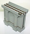 Model of wall section over land with original deck and dirt removed.
 -
 Model of wall section over land with original deck. Canton Viaduct Park is shown in the background.
 -
 Model of wall section over land with original deck and dirt removed.
 -
 Model of buttress section with original deck, dam and waterfall. The foundation stone is represented by the dark gray brick.
 -
 Model of buttress section with original deck and water removed.
 -
 Model of buttress section with original deck, dam and waterfall.
 -
 Model of buttress section with original deck and water removed.
 -
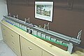 A complete Lego model of the Canton Viaduct is on display in the Reference room at the Canton Public Library.
 -


See also
- High Speed Rail's 1835 Underpinning from Invention & Technology magazine, Spring 2001 Volume 16, Issue 4
- Historic Canton Viaduct from the Portland Cement Association
Footnotes
- ^ The load limit of the structure itself is unknown. Granite, the principle component of the support structure, has a compressive strength that ranges upward from about 200 x 106 N/m2.
- ^ a b American Society of Civil Engineers article - Rebuilding History
- ^ Not the current distance, due to route changes.
- ^ Milepost at north end of the bridge
- ^ Plan of the Granite Railroad inclined planes
- ^ Borderland State Park Geology
- ^ Canton Historical Society: Old Canton Roads and Ways
- ^ Galvin, Edward D. (1987). A History Of Canton Junction.
{{cite book}}: External link in|title= - ^ Canton Historical Society: Canton Junction
- ^ Canton Journal index (1876 - 1890)
- ^ Former Canton Police Chief Bright's letter is public record, available at the Canton Police Department[1] and Canton's Board of Selectmen.[2]
- ^ "National Register Information System". National Register of Historic Places. National Park Service. 2008-04-15.
General references
- Boston Society of Civil Engineers
- Canton Historical Commission
- Canton Historical Society - A History of The Viaduct
- Massachusetts Historical Commission
- National Historic Landmarks Program
Further reading
- Galvin, Edward D. (1987). A History Of Canton Junction. Brunswick: Sculpin Publications.
- Cleary, Richard, L. (2007). Bridges. W.W. Norton & Co. ISBN 978-0393731361
- Canton Bicentennial Historical Committee. (1997), Canton Comes Of Age 1797-1997: A History Of The Town Of Canton, Massachusetts. Canton: The Town of Canton
- Comeau, George, T. (2009). Canton - Postcard History Series. Mount Pleasant: Arcadia Publishing. ISBN 978-0738572031
- Toy, Sidney. (1985). Castles: Their Construction And History. Dover Publications. ISBN 978-0486248981
- Boothroy, Stephen, J. (2002). Down At The Station: Rail Lines Of Southern New England In Early Postcards. Cranberry Junction. ISBN 978-0971496149
- Jackson, Donald, C. (1988). Great American Bridges And Dams. Wiley. ISBN 978-0471143857
- Barber, John, W. (1844). Historical Collections, Being A General Collection Of Interesting Facts, Traditions, Biographical Sketches, etc., Relating To The History And Antiquities Of Every Town In Massachusetts, With Geographical Descriptions, Illustrated By 200 Engravings. Heritage Books. ISBN 978-1556134630
- DeLony, Eric. (1993). Landmark American Bridges. Little Brown and Company. ISBN 978-0821220368
- Middleton, William, D. (1999). Landmarks On The Iron Road: Two Centuries OF North American Railroad Engineering. Bloomington: Indiana University Press. ISBN 978-0253335593
- Ruddock, Ted. (2000). Masonry Bridges, Viaducts And Aqueducts. Ashgate. ISBN 978-0860787518
- National Park Service. (1995). National Register Of Historic Places 1966 To 1994. Wiley. ISBN 978-0471144038
- Solomon, Brian. (2008). North American Railroad Bridges. Voyageur Press. ISBN 978-0760325278
- Adams, Charles, F. (1878). Railroads: Their Origin And Problems. Ayer Co. Publishing. ISBN 978-0405137648
- Harlow, Alvin, F. (1946). Steelways Of New England. New York: Creative Age Press, Inc.
- Cook, Richard, J. (1987). The Beauty Of Railroad Bridges: In North America - Then And Now. San Marino: Golden West Books. ISBN 978-0870950971
External links
{{{inline}}}
{{{inline}}}
- Canton River Watershed Watchdogs
- Canton Viaduct - Flickr
- Canton Viaduct - Friends
- Canton Viaduct - Google Maps (interactive)
- Canton Viaduct - Visitors Center
- Canton Viaduct - Wikirank
- Paul Revere's Copper Rolling Mill
- Russian American Cultural Center of Boston
| Topics | |
|---|---|
| Lists by state |
|
| Lists by insular areas | |
| Lists by associated state | |
| Other areas | |
| Related | |
- 1835 in the United States
- Bridges completed in 1835
- CSX Transportation bridges and tunnels
- Dams in Massachusetts
- Deck arch bridges
- Historic Civil Engineering Landmarks
- Historic preservation
- History of engineering
- National Register of Historic Places in Massachusetts
- Norfolk County, Massachusetts
- Parks in Massachusetts
- Railroad bridges in Massachusetts
- Railway bridges on the National Register of Historic Places
- Stone bridges
- Viaducts in the United States
- Waterfalls of Massachusetts