Zarraga: Difference between revisions
Appearance
Content deleted Content added
m Replace broken external link to t-macs.com with a link to census.gov.ph |
added re transfer of brgy tuburan-solbud |
||
| Line 8: | Line 8: | ||
Zarraga is politically subdivided into 24 [[barangay]]s. |
Zarraga is politically subdivided into 24 [[barangay]]s. |
||
In 1948, barangay Tuburan-Solbud was transferred from [[Santa Barbara, Iloilo|Santa Barbara]], [[Iloilo]].<ref>{{cite web|url=http://lawph.com/statutes/ra221.html|title=An act to transfer the barrio of Tuburan-Solbud from the municipality of Santa Barbara to the municipality of Zarraga, both of the province of Iloilo|publisher=LawPH.com|date=|accessdate=2011-04-08}}</ref> |
|||
{| border="0" |
{| border="0" |
||
Revision as of 10:52, 8 April 2011

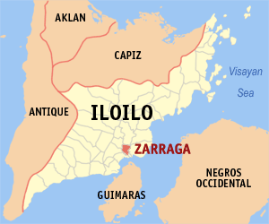
Zarraga is a 4th class municipality in the province of Iloilo, Philippines. According to the 2000 census, it has a population of 18,252 people in 3,507 households.
Barangays
Zarraga is politically subdivided into 24 barangays.
In 1948, barangay Tuburan-Solbud was transferred from Santa Barbara, Iloilo.[1]
|
|
