Oklahoma panhandle: Difference between revisions
Americasroof (talk | contribs) →History: maps |
m →External links: re-cat |
||
| Line 51: | Line 51: | ||
{{Oklahoma}} |
{{Oklahoma}} |
||
| ⚫ | |||
[[Category:1890 establishments]] |
[[Category:1890 establishments]] |
||
| ⚫ | |||
[[ja:オクラホマ・パンハンドル]] |
[[ja:オクラホマ・パンハンドル]] |
||
Revision as of 15:15, 23 February 2007
The Oklahoma Panhandle is the extreme western region of the state of Oklahoma, comprising Cimarron County, Texas County, and Beaver County. Its name comes from the similarity of shape to the handle of a cooking pan.
Description
Geography
The Panhandle is bordered by Kansas and Colorado at 37°N on the north, New Mexico at 103°W on the west, Texas at 36.5°N on the south, and the remainder of Oklahoma at 100°W on the east. The largest town in the region is Guymon, which is the county seat of Texas County. Black Mesa, the highest point in Oklahoma, is located in Cimarron County. The Panhandle lies in the High Plains portion of the Great Plains. The North Canadian River is named Beaver River or Beaver Creek on its course through the Panhandle.
Economy
The Panhandle is rather thinly populated (when compared to the rest of Oklahoma) making the labor force in this region very small. Nevertheless, farming and ranching operations occupy most of the economic activity in the region, with ranching dominating the drier western end. The region's higher educational needs are served by Oklahoma Panhandle State University, which is located in Goodwell, Oklahoma, 10 miles from Guymon.
History


The non-Native American history of the panhandle traces its origins being part of the Spanish New Spain empire. In 1821 it became a province of Mexico when Mexico achieved independence. In 1836 it became a disputed territory of the Republic of Texas. When Texas sought to enter the Union in 1845 as a slave state, federal law in the United States based on the Missouri Compromise prohibited slavery south of 36°30' parallel north. Texas ceded the strip and dropped its border 34 miles to 37th parallel north.
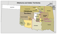
The 170 mile strip of land from New Mexico Territory to the 100th meridian west border of Oklahoma Territory was left with no formal territorial ownership called "Public Land Strip" and was more commonly referred to as "No Man's Land."
It was finally surveyed and settled following the Homestead Act in 1862 although no formal jurisdiction was established creating a scenario where settlers were self-governing and self-policing. In 1885 before the United States Supreme Court formally assigned its jurisdiction to Oklahoma Territory.
In the first half of the 19th century, a portion of the Panhandle was part of the the Santa Fe Trail trade route; it was referred to as the "Cimarron Cutoff." The Santa Fe Trail passed through what is now Boise City, Oklahoma and on to Clayton, New Mexico before contining toward Santa Fe.

By the second half of the 19th century, although in routine use, the Panhandle had remained unclaimed by any state or territory (from 1850, when it was ceded from Texas, until 1890, when it was assigned to Oklahoma Territory--see Neutral Strip). The Panhandle was Seventh County, with a county seat at Beaver City, from 1890 until statehood in 1907, when it was divided into the present three counties. Prior to then, the Panhandle was also commonly referred to as "No Man's Land".
Following the U.S. Census of 2000, the three counties of the panhandle were assigned to Oklahoma Congressional District 3, which, geographically speaking, is Oklahoma's largest Congressional district.
See also
Geography:
History:
Other state panhandles:
- Texas Panhandle
- Florida Panhandle
- Alaska Panhandle
- Idaho Panhandle
- Nebraska Panhandle
- West Virginia Panhandle

