Luyang, Hefei: Difference between revisions
Appearance
Content deleted Content added
No edit summary |
SimonWan00 (talk | contribs) Tags: Mobile edit Mobile app edit Android app edit |
||
| Line 134: | Line 134: | ||
*Xinglin Subdistrict ({{lang|zh|杏林街道}}) |
*Xinglin Subdistrict ({{lang|zh|杏林街道}}) |
||
|valign="top"| |
|valign="top"| |
||
*Haitang Subdistrict ({{lang|zh|海棠街道}}) |
*[[Haitang Subdistrict, Hefei|Haitang Subdistrict]] ({{lang|zh|海棠街道}}) |
||
*Xinghuacun Subdistrict ({{lang|zh|杏花村街道}}) |
*[[Xinghuacun Subdistrict, Hefei|Xinghuacun Subdistrict]] ({{lang|zh|杏花村街道}}) |
||
*Xiaoyaojin Subdistrict ({{lang|zh|逍遥津街道}}) |
*Xiaoyaojin Subdistrict ({{lang|zh|逍遥津街道}}) |
||
|valign="top"| |
|valign="top"| |
||
Latest revision as of 19:01, 23 June 2024
Luyang
庐阳区 | |
|---|---|
 | |
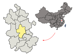
 Luyang in Hefei | |
 Hefei in Anhui | |
| Country | China |
| Province | Anhui |
| Prefecture-level city | Hefei |
| District seat | Bozhoulu |
| Area | |
| • Total | 139.32 km2 (53.79 sq mi) |
| Population (2020) | |
| • Total | 697,293 |
| • Density | 5,000/km2 (13,000/sq mi) |
| Time zone | UTC+8 (China Standard) |
| Postal code | 230001 |
| Website | Official Site |
Luyang District (simplified Chinese: 庐阳区; traditional Chinese: 廬陽區; pinyin: Lúyáng Qū) is one of four urban districts of the prefecture-level city of Hefei, the capital of Anhui Province, East China. It makes up the main part of the old city area of Hefei. It has a total area of 139.32 square kilometres (53.79 sq mi), and a population of 609,239 inhabitants.[1]
Administrative divisions
[edit]Luyang District is divided to 9 subdistricts, 1 town and 1 township.[2]
- Subdistricts
|
|
|
- Towns
- Dayang (大杨镇)
- Townships
- Sanshigang Township (三十岗乡)
References
[edit]- ^ (in Chinese) Compilation by LianXin website. Data from the Sixth National Population Census of the People's Republic of China Archived 2012-03-25 at the Wayback Machine
- ^ 2023年统计用区划代码和城乡划分代码:庐阳区 (in Simplified Chinese). National Bureau of Statistics of China.
External links
[edit]- Luyang District Government website (in Chinese)
31°51′48″N 117°14′49″E / 31.86333°N 117.24694°E
