
Lejre: Difference between revisions
Cuchullain (talk | contribs) m moved Lejre Municipality to Lejre: This article describes both town adn municipality. |
No edit summary |
||
| Line 12: | Line 12: | ||
==Attractions== |
==Attractions== |
||
The municipality is home to |
The municipality is home to [[The Land of Legends Lejre]], a center for [[experimental archaeology]] and [[education]], which includes reconstructions and recreations from different periods of Denmark’s history— from [[pre-history]] to the time of the [[Vikings]]. The centerpiece of the facility is an [[Iron Age]] village reconstruction, complete with sacrificial bog. The center is open to the public. |
||
==Images== |
==Images== |
||
| Line 29: | Line 29: | ||
* [http://www.english.lejrecenter.dk/ Lejre Experimental Centre] |
* [http://www.english.lejrecenter.dk/ Lejre Experimental Centre] |
||
* [http://www.tadremoelle.dk/public_html/tadre_htm/tadre_start.htm Tadre Mølle (Old Watermill)] |
* [http://www.tadremoelle.dk/public_html/tadre_htm/tadre_start.htm Tadre Mølle (Old Watermill)] |
||
* [http://www. |
* [http://www.landoflegends.dk/ The Land of Legends Lejre (formerly Lejre Experimental Centre)] |
||
== References == |
== References == |
||
Revision as of 06:56, 30 September 2009

Lejre is a town and municipality (Danish, kommune) on the island of Zealand in east Denmark. It belongs to Region Sjælland. The town's Old Norse name was Hleiðra. The municipality has an area of 240 km² and a total population of ca. 26,603 (2008). Its mayor is Flemming Jensen, representing the liberal Venstre political party. The municipal seat is Kirke Hvalsø.
Municipality
The current municipality was established on 1 January 2007 as a result of Kommunalreformen ("The Municipal Reform" of 2007), merging the former Lejre municipality with Bramsnæs and Hvalsø municipalities to form a new Lejre municipality. The former Lejre municipality covered an area of 88 km², and had a total population of 8,724 (2005). Its last mayor was Jens Hald Madsen, representing the Venstre party. Neighboring municipalities were Ramsø and Roskilde to the east, Bramsnæs to the north, Hvalsø to the west, and Hvalsø to the south. Most of the old municipality's northern border was defined by the waters of Roskilde Fjord. It belonged to Roskilde County.
History
Lejre was the capital of an Iron Age kingdom, the Lejre Kingdom, which was, according to legend, ruled by kings of the Skjöldung dynasty; it is assumed to be the predecessor of medieval Denmark. Lejre is assumed to have been the location of Heorot[citation needed], the royal hall mentioned in Beowulf and other myths that are set around the year 500. Archeological remains of large halls from this period have been found. The legends of the kings of Lejre were written down in the 12th century Chronicon Lethrense.
Attractions
The municipality is home to The Land of Legends Lejre, a center for experimental archaeology and education, which includes reconstructions and recreations from different periods of Denmark’s history— from pre-history to the time of the Vikings. The centerpiece of the facility is an Iron Age village reconstruction, complete with sacrificial bog. The center is open to the public.
Images
-
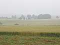 Lejre municipality is primarily rural.
 -
 May 2004.
 -
 Ledreborg palace, 19th century drawing


External links
- Municipality's official website
- The new Lejre municipality's official website (Danish only)
- Lejre Experimental Centre
- Tadre Mølle (Old Watermill)
- The Land of Legends Lejre (formerly Lejre Experimental Centre)
References
- Municipal statistics: NetBorger Kommunefakta, delivered from KMD aka Kommunedata (Municipal Data)
- Municipal mergers and neighbors: Eniro new municipalities map
