
Jay Mountain (New York)
| Jay Mountain | |
|---|---|
 | |
| Highest point | |
| Elevation | 3,600 ft (1,100 m) |
| Prominence | 2,149 ft (655 m) |
| Coordinates | 44°19′11″N 73°41′28″W / 44.31972°N 73.69111°W[1] |
| Geography | |
| Location | Jay, New York, U.S. |
| Parent range | Adirondacks |
| Topo map | USGS Au Sable Fork |
| Climbing | |
| Easiest route | Hike |
Jay Mountain is the 79th highest peak of the Adirondack Mountains. It is located in Essex County, New York, in the Jay Mountain Wilderness Area, within the towns of Jay and Lewis.[2]
Gallery
[edit]-
 Ascending Jay on the ridge looking south
 -
 View from west belvedere
 -
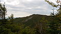 View of Jay Mountain highest peak from west belvedere
 -
 View from west belvedere with Champlain Lake in the background
 -
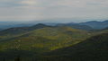
 South-west view from Jay's ridge


See also
[edit]References
[edit]- ^ United States Department of the Interior. "The USGS Store". USGS. USA.gov. Archived from the original on 1 June 2013. Retrieved 11 September 2013.
- ^ New York State Department of Environmental Conservation. "Jay Mountain Wilderness Area - Unit Management Plan". Department of Environmental Conservation. Department of Environmental Conservation. Retrieved 8 September 2013.