Indian Wells, Arizona
Indian Wells, Arizona | |
|---|---|
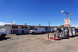
 Indian Wells Trading Post and Post Office | |
 Location of Indian Wells in Navajo County, Arizona. | |
| Coordinates: 35°24′20″N 110°5′5″W / 35.40556°N 110.08472°W | |
| Country | United States |
| State | Arizona |
| County | Navajo |
| Area | |
| • Total | 10.40 sq mi (26.93 km2) |
| • Land | 10.40 sq mi (26.93 km2) |
| • Water | 0.00 sq mi (0.00 km2) |
| Elevation | 6,250 ft (1,910 m) |
| Population (2020) | |
| • Total | 232 |
| • Density | 22.32/sq mi (8.62/km2) |
| Time zone | UTC-7 (Mountain (MST)) |
| ZIP codes | 86031 |
| FIPS code | 04-35310 |
| GNIS feature ID | 2582801[2] |
Indian Wells (Template:Lang-nv) is a census-designated place in Navajo County, Arizona, United States. Indian Wells Elementary School is located in the town, it serves 600 students. It is also the name of the local Navajo chapter of the Navajo Nation Council. Indian Wells is served by a post office with the ZIP code of 86031.[3] The ZIP Code Tabulation Area for ZIP Code 86031 had a population of 1,856 at the 2010 census, with 255 in Indian Wells itself.[4][5]
Geography
Indian Wells is located at 35°24′20″N 110°5′5″W / 35.40556°N 110.08472°W (35.4055684, -110.0848452).[2] According to the United States Census Bureau, the community has a total area of 10.4 square miles, all land.
Climate
According to the Köppen Climate Classification system, Indian Wells has a semi-arid climate, abbreviated "BSk" on climate maps.[6]
Demographics
| Census | Pop. | Note | %± |
|---|---|---|---|
| 2020 | 232 | — | |
| U.S. Decennial Census[7] | |||
As of the census[4] of 2000, there were 2,445 people, 633 households, and 508 families living in the ZCTA. There were 1,067 housing units. The racial makeup of the ZCTA was 1.3% White, 0.1% African American, 97.5% Native American, <0.1% from other races, and 1.1% from two or more races. Hispanic or Latino of any race were 0.9% of the population.
There were 633 households, out of which 54.3% had children under the age of 18 living with them, 49.6% were married couples living together, 24.3% had a female householder with no husband present, and 19.7% were non-families. 18.8% of all households were made up of individuals, and 6.8% had someone living alone who was 65 years of age or older. The average household size was 3.86 and the average family size was 4.49.
In the ZCTA the population was spread out, with 25.7% under the age of 18, 9.2% from 18 to 24, 25.8% from 25 to 44, 14.6% from 45 to 64, and 12.4% who were 65 years of age or older. The median age was 26.3 years. For every 100 females, there were 94.2 males. For every 100 females age 18 and over, there were 98.8 males.
Education

The school district is Holbrook Unified School District.[8] It operates Indian Wells Elementary School in Indian Wells.[9] Indian Wells Elementary, which opened in 2002, was built so students could attend elementary school in the community instead of in Holbrook.[10] The district's public secondary schools are Holbrook Junior High School and Holbrook High School.
References
- ^ "2020 U.S. Gazetteer Files". United States Census Bureau. Retrieved October 29, 2021.
- ^ a b c U.S. Geological Survey Geographic Names Information System: Indian Wells, Arizona
- ^ Zip Code Lookup
- ^ a b "American FactFinder". United States Census Bureau. Archived from the original on February 13, 2020. Retrieved October 15, 2018.
- ^ "American FactFinder". United States Census Bureau. Archived from the original on February 13, 2020. Retrieved October 15, 2018.
- ^ Climate Summary for Indian Wells, Arizona
- ^ "Census of Population and Housing". Census.gov. Retrieved June 4, 2016.
- ^ "2020 CENSUS - SCHOOL DISTRICT REFERENCE MAP: Navajo County, AZ" (PDF). U.S. Census Bureau. p. 2 (PDF p. 3/4). Retrieved March 18, 2023.
- ^ "Indian Wells Elementary School". National Center for Education Statistics. Retrieved March 21, 2023. - School's website
- ^ "Indian Wells Elementary School". DCSW. Archived from the original on December 30, 2005. Retrieved March 21, 2023.


