
Wikipedia:Graphics Lab/Illustration workshop
This page is deprecated and will not be monitored. Please use one of the three workshop pages. This specific page is {{{1}}}
-
 Logo for WikiProject Koei Warriors Games
 -
 Suggestion #1 ~~~~
 -
 My (BlueCaper's) new version for it


Article(s): WikiProject Koei Warriors Games
Request: Could you make a more detailed ".svg" version of it? Also, could there be like a black curve going off the tip of the sword in a 90° turn centered on the middle of the sword? (The black curve refers to the Koei Warriors Games' opening movies using black lines instead of blood.) Thank you! -BlueCaper (talk) 13:21, 13 January 2009 (UTC)
- I wasn't able to do the 90 degree curve. Also, I wasn't sure if you wanted it with the red background. Let me know if this is okay. ZooFari 03:25, 17 January 2009 (UTC)
- To be more correct, the W in the logo should be in the Garamond font instead of Times New Roman. The difference is that Garamond's W looks like two V's overlapping, while TNR has the W looking like the above SVG version (look at Wikipedia's logo, the W looks like two overlapping V's. Same with your red background logo). Let me know if you want the Garamond W, as I've got Garamond. [|Retro00064 | (talk/contribs) |] 23:42, 17 January 2009 (UTC)
- Thanks, but I used Paint.NET and public-domain Commons photography to create a .PNG version. I will use Inkscape to make it SVG. I will say something to the other WikiProject Koei Warriors Games members to see if they wish to use or build on your picture. I tried to figure out which font uses that extra serif on the "W," and I have Garamond, but I guess I just overlooked it. Thanks again! -BlueCaper (talk) 01:43, 19 January 2009 (UTC)
- To be more correct, the W in the logo should be in the Garamond font instead of Times New Roman. The difference is that Garamond's W looks like two V's overlapping, while TNR has the W looking like the above SVG version (look at Wikipedia's logo, the W looks like two overlapping V's. Same with your red background logo). Let me know if you want the Garamond W, as I've got Garamond. [|Retro00064 | (talk/contribs) |] 23:42, 17 January 2009 (UTC)
Graphist opinion:
Translation of text for a map (from Spanish to English)
-
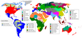 Map of the languages of the world

Article(s): Linguistic map
Request: Please see Wikipedia:Reference desk/Archives/Language/2009 January 11 (section "File Translation Needed").
-- Wavelength (talk) 05:38, 18 January 2009 (UTC)
Graphist opinion: This has already been done on commons, use File:Languages world map.svg. Kmusser (talk) 12:55, 3 February 2009 (UTC)
Iran map

Iran could use a new map please. —Preceding unsigned comment added by 83.108.234.37 (talk) 10:47, 18 January 2009 (UTC)
- Could you be more specific. What kind of map are you thinking of?bamse (talk) 15:14, 18 January 2009 (UTC)
- I'm thinking of a new map with the globe view. 83.108.234.37 (talk) 21:28, 19 January 2009 (UTC)
- Do you mean something like File:People's Republic of China (orthographic projection).svg but then for Iran? In my opinion such projection is more suited to large countries. I also don't see what would be gained over all the beautiful maps in commons:Atlas_of_Iran for instance. But maybe I misunderstand your request. bamse (talk) 22:32, 19 January 2009 (UTC)
- Well, Iran is 1,648,195 km2 large, and Mexico which has a land area of 1,972,550 km2, have a map like that. Its just some larger. :-) Its also made one for the UK though not in use anymore. And I know its called globe view, but does it need to bee zoomed out that much? Just look at Mongolia (1,564,116 km2) that map is showing the whole world... Its the better looking design that is importat to improve the article. Sorry for my bad english :-) 83.108.234.37 (talk) 14:59, 20 January 2009 (UTC)
- I changed colors in the Mongolia map. Is that ok? There is/was also File:LocationIran.svg. A map in orthographic projection (globe view) — which is not just a zoomed-in version — with Iran in the center would require creating a completely new map and possibly vectorize it (to make it svg). I don't really feel the need for such map. Maybe some other graphist would go for it. bamse (talk) 15:31, 20 January 2009 (UTC)
- Yeah I talked to user Ssolbergj who makes those types of maps. He seemd to be busy at the time I talked to him. But the File:LocationIran.svg looks good, can't you attatch that in the Iran article? Im not sure how to. 83.108.234.37 (talk) 16:04, 20 January 2009 (UTC)
- I changed colors in the Mongolia map. Is that ok? There is/was also File:LocationIran.svg. A map in orthographic projection (globe view) — which is not just a zoomed-in version — with Iran in the center would require creating a completely new map and possibly vectorize it (to make it svg). I don't really feel the need for such map. Maybe some other graphist would go for it. bamse (talk) 15:31, 20 January 2009 (UTC)
- Well, Iran is 1,648,195 km2 large, and Mexico which has a land area of 1,972,550 km2, have a map like that. Its just some larger. :-) Its also made one for the UK though not in use anymore. And I know its called globe view, but does it need to bee zoomed out that much? Just look at Mongolia (1,564,116 km2) that map is showing the whole world... Its the better looking design that is importat to improve the article. Sorry for my bad english :-) 83.108.234.37 (talk) 14:59, 20 January 2009 (UTC)
- Do you mean something like File:People's Republic of China (orthographic projection).svg but then for Iran? In my opinion such projection is more suited to large countries. I also don't see what would be gained over all the beautiful maps in commons:Atlas_of_Iran for instance. But maybe I misunderstand your request. bamse (talk) 22:32, 19 January 2009 (UTC)
- I'm thinking of a new map with the globe view. 83.108.234.37 (talk) 21:28, 19 January 2009 (UTC)
Badge of the Supreme Court of the United Kingdom
![]() Done per being used in article --80.42.25.80 (talk) 19:08, 8 February 2009 (UTC)
Done per being used in article --80.42.25.80 (talk) 19:08, 8 February 2009 (UTC)
-
Badge of the Supreme Court of the United Kingdom.
-
 Crown and floral elements can be taken from here.
 -
 SVG
SVG

Article(s):Supreme Court of the United Kingdom
Request: -Could someone please create an SVG version of the above badge for the Supreme Court of the UK. I have tried myself, however i'm not very good at circles. Thanks!- AlexD (talk) 21:40, 17 January 2009 (UTC)
Graphist opinion:
- Is that OK? Inductiveload (talk) 11:38, 4 February 2009 (UTC)
McDonald's Logo → SVG Image
Article(s): McDonald's
Request: This image would probably be better suited as an SVG image. I have no clue what I am doing when it comes to SVG, so it would probably be better for me to leave to more experienced users. ![]() Glacier Wolf 22:23, 21 January 2009 (UTC)
Glacier Wolf 22:23, 21 January 2009 (UTC)
Graphist opinion:
- It is always best to leave the logos at the current file, since they are non-free logos. Yet possible, graphists including me wouldn't risk the trace and therefore logos shouldn't even be attempted to be requested here in the graphics lab. ZooFari 00:21, 24 January 2009 (UTC)
- I was about to trace the file when I came across a PDF file from MickyD's themselves! I must have dne something wrong as I can't get the SVg to appear, I just get a red X. I checked and it doesn't appear there's any text, if anyone knows wha's up please step in. §hep • Talk 00:50, 24 January 2009 (UTC)
- Hmm... Did you remove the raster image from the document? ZooFari 00:53, 24 January 2009 (UTC)
- Made some code cleanup and got it to render. /03:16, 24 January 2009 (UTC)
- Hmm... Did you remove the raster image from the document? ZooFari 00:53, 24 January 2009 (UTC)
- I was about to trace the file when I came across a PDF file from MickyD's themselves! I must have dne something wrong as I can't get the SVg to appear, I just get a red X. I checked and it doesn't appear there's any text, if anyone knows wha's up please step in. §hep • Talk 00:50, 24 January 2009 (UTC)
- Not exactly sure what you did, but thanks. §hep • Talk 03:37, 24 January 2009 (UTC)
Here you are. -- 212.41.91.155 (talk) 03:47, 24 January 2009 (UTC)
North Sea map improvements and or feedback
-
 Currents in the North Sea
 -
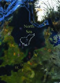 Map showing neighboring placenames, and features in the North Sea, two bathymetric projections of greater areas.
 -
 Map showing neighboring placenames, and features in the North Sea, two bathymetric projections of greater areas.
 -
 Map showing neighboring placenames, and features in the North Sea


Article(s): North Sea
Request: The currents map stated above has little straight arrows upon it showing current direction, but would be improved with curvy arrows which would be more similar to flowing water motion. There are 3 online sources cited for verifiability on the above image.... SriMesh | talk 04:12, 23 January 2009 (UTC)
' The 3 similar maps show features and placenames are located because of Geography of the North Sea has upon it the use of a geograph template and the Geography of the North Sea article cites sources for the latitudes and longitudes, which have been used. I am not sure which to save. Are the maps wikipedia friendly, or is there an opinion on these for improvements?
Kind Regards SriMesh | talk 04:12, 23 January 2009 (UTC)
'Graphist opinion:
Solingen arson attack photo touch-up
-
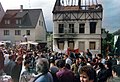 Scanned photo with red glare on one side

Article(s): Solingen arson attack of 1993
Request: Any way the red glare or whatever it is can be removed to create a better-looking photo? Thanks in advance! 79.64.251.192 (talk) 19:39, 24 January 2009 (UTC)
Graphist opinion: Removed the glare and improved the contrast. How is it now? Mononomic (talk) 02:46, 31 January 2009 (UTC)
- (Not requester) That looks really good! Would it be possible to un-blowout the sky? Or is it too far gone? §hep • Talk 02:49, 31 January 2009 (UTC)
- Too far gone - I tried. Sorry. Mononomic (talk) 20:30, 2 February 2009 (UTC)
- It is never too far gone to me:) The only unfortunate thing about my changes is that I had to remove the Antenna from the house, as I used the clone tool to clone the sky from different areas of the image. Let me know if this works for you. ZooFari 01:48, 5 February 2009 (UTC)
- Too far gone - I tried. Sorry. Mononomic (talk) 20:30, 2 February 2009 (UTC)
Governor's Island
-
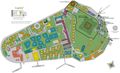 Official jpg map
 -
 SVG
SVG


Article(s): Governors Island
Request: Perfect candidate to SVGizize. High enough quality to trace. Bad enough JPG encoding to really warrant it being made into SVG. An official map so it should be very accurate. And a worthy part of a very important city. Also the NPS site page is now down so the numbers don't have a corresponding key. They should probably be removed and then a new numbering scheme can be easily added to the SVG if someone finds the old key or wants to make their own. gren グレン 01:00, 25 January 2009 (UTC)
Graphist opinion:
- On it! Inductiveload (talk) 21:03, 3 February 2009 (UTC)
- There you go. Looks a bit odd at low res due to Wikimedia rendering not being so hot on the text, but it's fine if you zoom in. I've put a provisional key in the image page, but you'll have to finish that yourself when you can get hold of the proper key. Inductiveload (talk) 23:47, 3 February 2009 (UTC)
North American Union
-

-
 this one is the proper perspective, if the states and provinces can be removed


Article(s): North American Union
Request: straighten perspective, this doesn't need to be skewed like a globe... Chris (クリス • フィッチ) (talk) 09:20, 25 January 2009 (UTC)
Graphist opinion: commons:Category:North America has tons of maps. Just choose one you like and someone can fill in colors you like. Any reason the one currently at North American Union isn't good? The one you linked is at North American currency union gren グレン 00:08, 27 January 2009 (UTC)
- this one is the proper perspective, if the states and provinces can be removed Chris (クリス • フィッチュ) (talk) 00:38, 5 February 2009 (UTC)
Jan Mayen

Article(s): Jan Mayen
Request: Can we get a closer-in map? Chris (クリス • フィッチ) (talk) 09:24, 25 January 2009 (UTC)
Graphist opinion:
Lee shore SVG


Articels: Lee shore
Request: SVGify if possible. It doesn't have to be the same island shape. 76.117.247.55 (talk) 01:58, 27 January 2009 (UTC)
Oppinion:
- How's that? Maui seems like a good example here, becuase it has that hidden lee shore. Inductiveload (talk) 22:23, 1 February 2009 (UTC)
Channel Tunnel traffic figures
-
 Diagram with outdated data

Article(s): Channel Tunnel
Request: There is new 2008 data out, and I dug up precise data to replace the earlier data. I put a detailed request on the file's talk page, and also a request at the present file's creator's page, but no reaction so far. Could someone else jump in? Thanks in advance! --Rontombontom (talk) 14:23, 28 January 2009 (UTC)
Graphist opinion:
Endoplasmatic reticulum
-
 Bad quality jpg.

Article(s): Endoplasmatic Reticulum
Request:Almost every cell structure reproduction is in svg, so I'd appriciate if you could make this one as well.
Thanks!
Thanks for your time!
Graphist opinion:
Map of Colorado counties

Article(s):
Request: for some reason, this comes up as grainy when scarled, can this be fixed? Chris (クリス • フィッチ) (talk) 16:30, 29 January 2009 (UTC)
Graphist opinion:
Jean-Hilaire Aubame
-
 Jean-Hilaire Aubame

Article(s): Jean-Hilaire Aubame
Request: Could someone crop the black guy in this photo? ~EDDY (talk/contribs/editor review)~ 21:18, 30 January 2009 (UTC)
- Do you mean with the black guy in or out of the crop? ZooFari 01:54, 2 February 2009 (UTC)
- I want to remove the white guy and tagline. ~EDDY (talk/contribs/editor review)~ 00:11, 4 February 2009 (UTC)
Graphist opinion:
- How is that? ZooFari 01:52, 5 February 2009 (UTC)
Korea barnstar
-

-

-
 Composite of images found on User:PC78/notes
 -
 Finished product (so far)

Article(s): WikiProject Korea
Request: Currently there is no barnstar or other award for Korea-related topics, so I would like to request a suitable image. The only stipulation I have is that it in some way incorporates the sam-taeguk symbol (shown above). All other considerations, such as whether or not it uses the original barnstar image, I leave at the discretion of whoever takes up this request, so feel free to go nuts! Thanks in advance. :) PC78 (talk) 15:30, 31 January 2009 (UTC)
Graphist opinion: 'Kay, here's a Composite of stuff found on User:PC78/notes' page. I am an Inkscape begginer, of course, but I hope this looks O.K. Resident Mario (talk) 20:49, 2 February 2009 (UTC)
- Ths is sutibale for a hanging medal. Resident Mario (talk) 19:55, 3 February 2009 (UTC)
- Comment: The bird is quite hard to see red on red... Mangwanani (talk) 20:47, 3 February 2009 (UTC)
- Hope you like it. Maybe the ribbon should be wider? Hard to see? Give me a moment Resident Mario (talk) 20:55, 3 February 2009 (UTC)
- Done Resident Mario (talk) 21:01, 3 February 2009 (UTC)
- Cheers! Not quite what I was after, but I'm sure we can make use of it. Thanks for your efforts (and sorry for the late reply, I've been a bit sidetracked with other stuff). PC78 (talk) 20:00, 6 February 2009 (UTC)
- thank you Resident Mario (talk) 19:00, 7 February 2009 (UTC)
- Done Resident Mario (talk) 21:01, 3 February 2009 (UTC)
Canadian Loonie

Article(s): None yet.
Request: Could we get a SVG of this, please? Going on my userpage, and possible other. Precisely in Nuvola apps style, please. Connormah (talk) 19:44, 31 January 2009 (UTC)
Graphist opinion:
- Since this image is unfree it (or any svg version based on it( wouldn't be allowed on your userpage. /Lokal_Profil 01:26, 1 February 2009 (UTC)
Srebrenica

Article(s): Srebrenica Genocide memorial
Request: Crop above the time stamp and sharpen PRODUCER (TALK) 21:43, 1 February 2009 (UTC)
Graphist opinion:
- How is that? I didn't think it need croping. I just removed the timestamp, and since I was at it, I did additional fixes. ZooFari 01:52, 2 February 2009 (UTC)
Gas Pipeline
-
ნაბუქოს გაზსადენი
Article(s): ნაბუქო
Request: Change the current image with thisTutber eng (talk) 01:30, 2 February 2009 (UTC)
Graphist opinion:
Somalia map

.svg)
Article(s): Somalia
Request: remove shading on wording, somehow make more legible... Chris (クリス • フィッチ) (talk) 08:37, 2 February 2009 (UTC)
Graphist opinion:
- On it, but this will take a while. Inductiveload (talk) 10:54, 3 February 2009 (UTC)
- Ok, I've got a far as a good map of Smalia, with all the borders that are on that diagram. However I am not sure what borders are which (state, region, district), and they don't always seem to align to the borders on other maps (there are several regions which are named but I can't see in the WP articles. ISince Somalia is in such turmoil, I don't know what goes where. Somone up-to-date with the sistuation/history would be better than me. I have also put a very few minor and major settlements on (they're in a hidden layer of the SVG currently), but I don't think it is useful to show these if this is intended to show the political situation rather than geography. Rivers are included, but roads are not. The image is also included in the SVG as a hidden layer, to make it easy to trace stuff on top. When this is all finished, that can be taken out. Inductiveload (talk) 13:01, 3 February 2009 (UTC)
- Wow you're fast, and good with fine details! I like the color scheme you've chosen better, as well. Chris (クリス • フィッチュ) (talk) 13:45, 3 February 2009 (UTC)
- I've changed the colours to match the "standard" maps you see on WP, and added some cities and stuff. I'm going to leave it there for now, but the image is still in a hidden layer for reference. Ideally, this will be the map that is used for making future maps of the Somalia situation, as it should be relatively easy to change the boundaries. Also, the Wikimedia SVG engine seems to be struggling to render the text nicely at lower resolution. Inductiveload (talk) 14:54, 3 February 2009 (UTC)
Merge two pictures
-
 Iowa portion
 -
 South Dakota portion
 -
 Montage


Article(s): Blood Run Site
Request: This site is a National Historic Landmark with no picture in its infobox. As it's split between two US states, the US gov't website where I found these has a picture of each part, but not a single picture of the whole site. Since neither picture is more representative of the other, I'd like to have these two pictures merged (made into one image, montaged, whatever you want to call it) so that we can show both pictures in the infobox equally. Border will need to be removed first. Oh, also: could we have the South Dakota portion up top, since South Dakota is farther north? Nyttend (talk) 16:18, 3 February 2009 (UTC)
Graphist opinion: How's that? Mfield (talk) 07:19, 9 February 2009 (UTC)
- Looks good, both by itself and in the article. Thanks! Nyttend (talk) 20:14, 9 February 2009 (UTC)
NA Basement Rocks

Article(s): Lake Superior, Geology of North America, Lake Nipigon, User:SEWilco/Images, Talk:Abiogenic petroleum origin/Archive 1, Slave craton, Superior craton, Churchill craton, Rae craton, List of shields and cratons, Midcontinent Rift System, Volcanism in Canada, File:North america terrain 2003 map.jpg, Innuitian orogeny, Trans-Hudson orogeny, Wyoming craton.
Request: Reposting, because this one has been forgotten, and I feel this is very urgent, because this image is used in over 20 articles. Please vectorize, and change colors to Wikipedia-style, as the current ones are quite blinding. Thanks. Connormah (talk) 23:24, 8 January 2009 (UTC)
- Sorry to bump, but I feel this NEEDS to be done...Connormah (talk) 23:59, 16 January 2009 (UTC)
- And I'll put my opinion again. This map does not offer enough detail to do a proper vectorization. Yes, the colors can be changed... but this map has such little detail that a vector will be just as completely inaccurate. You might want to try finding more precise information and sources of any sort to substantiate these boundaries and help create a better map. gren グレン 01:12, 6 February 2009 (UTC)
Graphist opinion:
- I've had a look at this one, and due to the extremely small size, and the very inaccurate and unorthodox projection of the map, it will be impossible to transfer the data with any sensible degree of accuracy to SVG. With better data, an SVG can be made, especially if the projection is similar to an existing map of North America such as this one, or similar. Inductiveload (talk) 02:07, 6 February 2009 (UTC)
Pacific Ring of Fire volcanoes
-
Original PNG Map of the RoF & Mts. Mayon, Krakatau, St. Helens, Pinatubo, and Garibaldi
-
 this could be used as a clearer base map

Article(s): Pacific Ring of Fire
Request: Convert into SVG and fine-tune it, please. -BlueCaper (talk) 18:48, 4 February 2009 (UTC)
Graphist opinion:
Coat of arms of Cameroon

Article(s): Coat of arms of Cameroon
Request: republic is misspelled in small text, see http://vector-images.com/image.php?epsid=4544 Chris (クリス • フィッチュ) (talk) 10:19, 6 February 2009 (UTC)
Graphist opinion:
- Done. /Lokal_Profil 17:50, 7 February 2009 (UTC)
- Thank you! Can you center the "of" now that the removed letter left more space? Also, can this be SVGified? 06:51, 9 February 2009 (UTC)
Baku Olympic bid logo

Article(s): 2016 Summer Olympics, 2016 Summer Olympics bids and Baku 2016 Olympic bid.
Request: SVGify and upload as "File:Baku 2016 Summer Olympics bid logo.svg" -- Felipe C.S ( talk ) 15:08, 7 February 2009 (UTC)
Graphist opinion:
Doha Olympic bid logo
Article(s): 2016 Summer Olympics, 2016 Summer Olympics bids and Doha 2016 Olympic bid.
Request: SVGify and upload as "File:Doha 2016 Summer Olympics bid logo.svg" -- Felipe C.S ( talk ) 15:08, 7 February 2009 (UTC)
Graphist opinion:
Prague Olympic bid logo

Article(s): 2016 Summer Olympics, 2016 Summer Olympics bids and Prague 2016 Olympic bid.
Request: SVGify and upload as "File:Prague 2016 Summer Olympics bid logo.svg" -- Felipe C.S ( talk ) 15:08, 7 February 2009 (UTC)
Graphist opinion:
Flags of French Overseas Territories
-
 Flag of the Minister of Overseas France


Article(s): French Overseas Territories related
Request: SVG please and name Flag of French Guiana, Flag of Réunion etc --SelfQ (talk) 23:24, 7 February 2009 (UTC)
Graphist opinion: Please note that the French Guiana flag is nominated as a "Possibly unfree image" and should probably be treated as Fair Use only. /Lokal_Profil 23:53, 7 February 2009 (UTC)
Loonie and Toonie Clipart

Article(s): None yet...
Request: Please attempt to vectorize. Thanks in advance! Connormah (talk) 05:07, 8 February 2009 (UTC)
Graphist opinion:
- How is this any different from Wikipedia:Graphic Lab/Image workshop#Canadian Loonie? Please don't repost requests, but instead, why not try to respond to the original request? You do not state the purpose for these images, nor what article they will go in. You are also requesting SVG work on a non-free image. Since non-free images have very limited use, and the amount of work required into recreating such an image in SVG format is high, they pay off is generally not worth it, so I'm not sure there would be anyone willing to do this request, especially given there is no stated purpose or article for such a conversion. Why do you want these images? And what is wrong with the current images (and how would SVG fix your perceived issue?)-Andrew c [talk] 14:51, 9 February 2009 (UTC)
South Korea map
-

-
 How about this map?
Article(s): {{WikiProject Korea}}
Request: This should be fairly straightforward. What I need is a version of the above map which makes South Korea (the light green bits) more visible when reduced to that size. I'm not too fussy on how it's done; if it's any help, maps like this have areas highlighted in pink, or another option would be to use colours similar to this map. Thanks in advance! PC78 (talk) 02:27, 9 February 2009 (UTC)
Graphist opinion: Does the location map work for you? On such a small size you won't see much detail anyway. Where do you need such a tiny map?bamse (talk) 11:03, 9 February 2009 (UTC)
- Actually that's not bad (must have missed that one). I need it for the project banner, as an icon for the South Korean geography work group. PC78 (talk) 11:29, 9 February 2009 (UTC)
Velupillai Prabhakaran

.svg)
Article(s): Velupillai Prabhakaran
Request: remove background so not so jingoist... Chris (クリス • フィッチュ) (talk) 14:14, 9 February 2009 (UTC)
Graphist opinion: