Congo River
| Congo River | |
|---|---|
 | |
| Physical characteristics | |
| Mouth | Atlantic Ocean |
| Length | 4,700 km (2,922 mi) |
The Congo River (also known as the Zaire River) is the largest river in Western Central Africa. Its overall length of 4,700 km (2,922 miles) makes it the second longest in Africa (after the Nile).
Background

The river and its tributaries flow through the second largest rain forest area in the world, second only to the Amazon Rainforest in South America. The river also has the second-largest flow in the world, behind the Amazon; the second-largest drainage basin of any river, again trailing the Amazon; and is the deepest river in the world, at depths greater than 750 feet.[1][citation needed] Its drainage basin is slightly larger than that of the Mississippi. Because large sections of the river basin lie above and below the Equator, its flow is stable, as there is always at least one river experiencing a rainy season.[2] The Congo gets its name from the ancient Kingdom of Kongo which inhabited the lands at the mouth of the river. The Democratic Republic of the Congo and the Republic of the Congo, both countries lying along the river's banks, are named after it. Between 1971 and 1997 the government of then-Zaire called it the Zaire River.
The sources of the Congo are in the highlands and mountains of the East African Rift, as well as Lake Tanganyika and Lake Mweru, which feed the Lualaba River, which then becomes the Congo below Boyoma Falls. The Chambeshi River in Zambia is generally taken as the source of the Congo in line with the accepted practice worldwide of using the longest tributary, as with the Nile River.

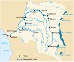
The Congo flows generally northwards from Kisangani just below the Boyoma falls, then gradually bends southwestwards, passing by Mbandaka, joining with the Ubangi River, and running into the Pool Malebo (Stanley Pool). Kinshasa (formerly Léopoldville) and Brazzaville are on opposite sides of the river at the Pool, where the river narrows and falls through a number of cataracts in deep canyons (collectively known as the Livingstone Falls), running by Matadi and Boma, and into the sea at the small town of Muanda. Due to its flow through some of the highest canyons, it has recently been discovered that the Congo River is the deepest river in the world, with measured depths in excess of 750 feet.Template:Http://research.amnh.org/ichthyology/congo/index 02.html
The Congo River Basin is one of the distinct physiographic sections of the larger Mid-African province, which in turn is part of the larger African massive physiographic division.
Economic importance
Although the Livingstone Falls prevent access from the sea, nearly the entire Congo is readily navigable in sections, especially between Kinshasa and Kisangani. Large river steamers worked the river until quite recently. The Congo River was a lifeline in a land without roads or railways. The steamers moved people, timber, and supplies. Whether these vessels survived the decay of the Mobutu years or the civil wars is in doubt.[why?]
Hydroelectric power
Railways now bypass the three major falls, and much of the trade of central Africa passes along the river, including copper, palm oil (as kernels), sugar, coffee, and cotton. The river is also potentially valuable for hydroelectric power, and the Inga Dams below Pool Malebo are first to exploit the river.
In February, 2005, South Africa's state-owned power company, Eskom, announced a proposal to increase the capacity of the Inga dramatically through improvements and the construction of a new hydroelectric dam. The project would bring the maximum output of the facility to 40 GW, twice that of China's Three Gorges Dam.[3]
Tributaries
|
Sorted in order from the mouth heading upstream. |
 
|
Literature
Although not explicitly cited, the Congo River is the location of Joseph Conrad's 1902 novel Heart of Darkness.
The Congo River is featured in a chapter of Michael Crichton's novel Congo (published in 1980), as well as the feature film of the same name, though it is not mentioned by name in the film.
The Congo is also mentioned in Langston Hughes' poem "The Negro Speaks of Rivers"
Silence, A Fable is a radio drama adaptation of Edgar Allan Poe's short story written in 1837 and set in Libya, "by the borders of the river Zaire". Redmond O"Hanlon (British) has a travelogue recently published by Penguin Books under the title of "Congo Journey".
According to TV advertisements for the mixed-fruit beverage Um Bongo, "they drink it in the Congo". However, it is not clear whether this refers to either or both of the countries that have 'Congo' as part of their name, or to the river.
See also
In Barbara Kingfisher's book, The Poison Bible a missionary and his family ends up in the Congo. The book gives an insiteful look into the politics influenced by America, France and Belgium during the sixties and how the Congo river influenced the daily exictance of the local population.
References
- ^ Per National Geographic Channel's "Explorer" series, "Monster Fish of the Congo" episode, 2009. http://channel.nationalgeographic.com/series/explorer/3826/Overview
- ^ The Congo River
- ^ Could a $50bn plan to tame this mighty river bring electricity to all of Africa? | World news | The Guardian
Further reading
- Tim Butcher: Blood River - A Journey To Africa's Broken Heart, 2007. ISBN 0-701-17981-3
- H. Winternitz, East Along the Equator: A Journey up the Congo and into Zaire (1987)

