
Wanneroo Road
Wanneroo Road | |
|---|---|
 | |
| General information | |
| Type | Error: |type= not defined (help) |
| Length | 76 km (47 mi) |
| Opened | 1920s |
| Route number(s) | Part of State Route 60 |
| Walcott Street, Morley Drive, Reid Highway, Warwick Road, Hepburn Avenue, Gnangara Road, Whitfords Avenue, Ocean Reef Road, Joondalup Drive, Gingin Brook Road
for full list see Major intersections | |
| Location(s) | |
| via | Tuart Hill, Wanneroo, Yanchep, Guilderton |
Wanneroo Road is an important arterial road in Perth, Australia. It is about 75 kilometres long. It links Perth with the City of Wanneroo, and the Towns of Yanchep and Lancelin. It starts from Charles Street in the Perth CBD and then becomes Perth-Lancelin Road after Gingin Brook Road in Woodridge.
After the enactment of the Road Districts Act 1871, the Perth Road Board requested that the Legislative Council proclaim eight public thoroughfares through its territory,[1] and on 4 June 1872, Road No.3, intended as a route from Perth to Champion Bay (now Geraldton) via Wanneroo, was published in the Government Gazette.[2] However, the act of proclaiming a road did not magically bring it into existence, and progress on surfacing the track occurred at a slow rate.
Originally a narrow and often country road with a single lane in each direction it has been periodically widened and (particularly north of Wanneroo) straightened. Around the Carabooda area the road has been realigned. Short sections of the original, narrow road remain providing access to properties along the road. These give a taste of what travel on the road used to be like.
Important roads and areas
Major Intersections
All major intersections are controlled by traffic lights except Pinjar Road and all roads north of Joondalup Drive.
 Green Street & Walcott Street - to Mount Lawley, Joondanna, Mount Hawthorn, Glendalough, Osborne Park.
 London Street - to Mount Hawthorn, Leederville.
 Morley Drive - to Dianella, Yokine, Morley, Nollamara, Stirling, Innaloo.
- Main Street - to Balcatta, Tuart Hill, Osborne Park.
 Balcatta Road - to Balcatta.
 Reid Highway - to Mirrabooka, Malaga, Beechboro, Carine.
- Beach Road - to Girrawheen, Balga, Koondoola, Mirrabooka, Warwick, Hamersley, Carine, Duncraig.
 Warwick Road - to Warwick, Greenwood, Duncraig.
- Marangaroo Drive - to Marangaroo, Girrawheen, Alexander Heights, Koondoola, Ballajura.
 Hepburn Avenue - to Marangaroo, Madeley, Darch, Kingsley, Greenwood, Duncraig, Padbury.
 Gnangara Road - to Madeley, Wangara, Landsdale, Gnangara, Ellenbrook, Henley Brook.
- Whitfords Avenue - to Woodvale, Kingsley, Padbury, Craigie.
 Ocean Reef Road - to Wangara, Pearsall, Woodvale, Edgewater, Beldon, Heathridge.
- Dundebar Road - to Wanneroo, Sinagra.
 Pinjar Road - to Ashby, Tapping, Mariginiup, Banksia Grove.
 Joondalup Drive - to Joondalup, Edgewater, Burns Beach, Carramar, Tapping, Banksia Grove.
- Hester Avenue - to Clarkson, Ridgewood, Merriwa.
- Yanchep Beach Road - to Yanchep.
- Breakwater Drive - to Two Rocks.
- Gingin Brook Road (Woodridge) - to Gingin
Photos
-
 Looking south near Balcatta Road (12 km)
 -
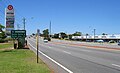
 Looking south near Hester Avenue (29 km)
 -
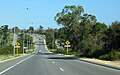
 Looking north near One Tree Hill (31 km)
 -
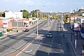 Looking South, towards Perth in Tuart Hill


See also
References