
Marrakesh
31°38′N 8°0′W / 31.633°N 8.000°W
Marrakech
مراكش Murrākush | |
|---|---|
| Country | |
| Region | Marrakech-Tensift-El Haouz |
| Province | Marrakech Province |
| Population (2004) | |
| • Total | 1,070,838 |
Marrakech or Marrakesh (Amazigh: Murakush, Arabic مراكش marrākuš, marrākiš), known as the "Red City", is an important and former imperial city in Morocco. The city of Marrakech is the capital of the mid-southwestern economic region of Marrakech-Tensift-Al Haouz, near the foothills of the snow-capped Atlas Mountains.
Like many North African cities, the city of Marrakech comprises both an old fortified city (the médina) and an adjacent modern city (called Gueliz) for a total population of 1,070,838.[1] It is served by Ménara International Airport (IATE code: RAK) and a rail link to Casablanca and the north.[1]
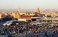
Marrakech has the largest traditional market (souk) in Morocco and also has one of the busiest squares in Africa and the world, Djemaa el Fna.[2] The square bustles with acrobats, story-tellers, water sellers, dancers and musicians. By night food stalls open in the square turning it into a huge busy open-air restaurant.
Name

The city is spelled "Marrakech" in French, "Marrakech" or "Marrakesh" in English, "Marrakesch" in German and "Marakeş" in Turkish. The probable origin of its name is from the Amazigh (Berber) words mur (n) akush (ⵎⵓⵔ ⵏ ⴰⵅⵓⵙⵂ), which means "Land of God". (The root "mur" is used now in the Berber languages mostly in the feminine form "tamurt"). The same word "mur" appears in the names Mauretania, the North African kingdom of the Maghreb during antiquity, and in contemporary Mauritania, the nation-state southwest of Morocco, although the link remains controversial as these names may also originate from navros, the ancient Greek word for black.
Until a few decades ago, Morocco was widely known as "Kingdom of Marrakech" to Arabs, Persians and Europeans. The European names of Morocco (Marruecos, Marrocos, Maroc, Marokko, etc.) are directly derived from the Berber word Murakush, and in many South Asian languages the country is in fact still known as "Marrakesh". Conversely, the city itself was in earlier times simply called Marocco (City) (or similar) by travellers from abroads. The name of the city and the country diverged after the Treaty of Fez placed Morocco under French influence, but the old interchangeable usage lasted widely until about the interregnum of Mohammed Ben Aarafa. The latter episode set in motion the country's return to independence, when Morocco officially became al-Mamlaka al-Maġribiyya (المملكة المغربية) – "The Western Kingdom" –, its name not referring to the city of Marrakesh anymore.
History

Prior to the advent of the Almoravids in the 11th century, the area was ruled from the city of Aghmat. The Almoravid leader, Abu-Bakr Ibn-Umar decided Aghmat was becoming overcrowded and chose to build a new capital. He decided to build it in the plains near the Tensift River. He chose the site of Marrakech, because it was in neutral territory between two tribes who were vying for the honor of hosting the new capital.[citation needed] Work started in May 1070, but Abu-Bakr was recalled to the Sahara to put down a rebellion in January 1071 and the city was completed by his deputy and eventual successor Yusuf ibn Tashfin.[3] The city experienced its greatest period under the leadership of Yaqub al-Mansur, the third Almohad sultan. A number of poets and scholars entered the city during his reign and he began the construction of the Koutoubia Mosque and a new kasbah.
Prior to the reign of Moulay Ismail, Marrakech was the capital of Morocco. After his reign, his grandson moved the capital back to Marrakech from Meknès.
.jpg)
For centuries Marrakech has been known for its 'seven saints.' When sufism was at the height of its popularity, during the reign of Moulay Ismail, the festival of the 'seven saints' was founded by Abu Ali al-Hassan al-Yusi at the request of the sultan. The tombs of several renowned figures were moved to Marrakech to attract pilgrims in the same way Essaouira did at that time with its Regrega festivals. The 'seven saints' (sebaatou rizjel) is now a firmly established institution, attracting visitors from everywhere. The seven saints include Sidi Bel Abbas (the patron saint of the city), Sidi Muhammad al-Jazuli, Sidi Abu al-Qasim Al-Suhayli, Cadi Ayyad ben Moussa, Abdelaziz al-Tebaa and Abdallah al-Ghazwani.
Marrakech was dominated in the first half of the 20th century by T'hami El Glaoui, "Lord of the Atlas" and Pasha of Marrakech. The poet of the city was Mohammed Ben Brahim, his favorite place was café Al-Masraf. The poems and songs of Ben Brahim are still known by heart by many Marrakshi.
Demographics
Marrakech had an official number of population of 1,070,838 in 2004.[1] There is a very large international community consisting mainly of Europeans estimated at 10,700 people, mostly retired.[citation needed]
Economy
Atlas Blue, a budget airline, has its head office on the grounds of Marrakech-Menara Airport.[4]
Main sights

Many tourists venture from Marrakech to visit the valley of the Ourika River in the Atlas Mountains or the valley of the Draa River in the south, near the Sahara desert. They also tour the Middle Atlas Mountains, where the Waterfalls of Beni Mellal are found, and to Essaouira on the Atlantic ocean. For all infos on sight seeing experience, please visit http://www.marrakech-loisirs.com who will be able to advise on trips and places of interests. For the city tour, it's best to venture out and explore by yourself and get lost in the Medina - as it is fun and there is no need to get any guides or services.
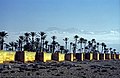
Geography: Unique Landscapes At the foot of the High Atlas, the highest mountainous barrier in North Africa, with the doors of the desert to the south and the Atlantic Ocean to the west, Marrakech benefits from a strategic geographical position and from a site of a special beauty. Stretching over 700 kilometers, the High Atlas chain features a series of peaks of which a dozen attain 4,000 meters. Lasting all winter long, snow can be found on hilltops as low as 600 meters of altitude. Seen from Marrakech, the imposing mountains and their snow-capped summits display a surreal, spellbinding decor. A few kilometers away, on the sides of the first foothills, the greatness and strangeness of the magical landscapes of the Atlas become a compelling sight-- a sight regarded as one of the most beautiful in the world. To the south, arise the stretches of steppes’ terrain that forewarn of the burning winds and the rigor of the Sahara. Beyond the 130,000 hectares of greenery and the 180,000 palm trees of its Palmeraie, Marrakech is an oasis of great and rich plant variety. Throughout the seasons, orange, fig, permanganate and olive trees spew out their fragrances and display their marvelous colors and luscious fruits. The precious gardens of the city conceal numerous native plants or other species that have been imported in the course of the centuries: Giant bamboos, yuccas, papyrus, palm trees, banana trees, cypress, philodendrons, rosebushes, bougainvilleas, pines and various kinds of cactus plants.
Transport

- Menara International Airport serves as the main airport for the city and receives flights from Europe and neighboring Arab countries.
- A toll-paying motorway connects Marrakech with Casablanca.
- CTM coaches (intercity buses) and various private lines run services to most notable Moroccan towns as well as a number of European cities, from the Gare Routière on Rue Bab Doukkala in downtown Marrakech.
- Marrakech is the southern terminus of the ONCF, the Moroccan railway network, and Marrakech is well served by trains heading to Tangier, Rabat, Casablanca, and Fes. The Marrakech railway station is located on Avenue Hassan II.
- The ONCF-owned "Supratours" bus company serves towns not served by the train. The bus timetable coordinates with the train timetable and the bus terminal is right beside the station.
Notable residents
- Juan Goytisolo, Spanish novelist
- Yves Saint-Laurent, French designer and artist
- Jean-Paul Gaultier, French fashion designer and grand couturier
- Mohamed Abdelaziz, President of the Sahrawi Arab Democratic Republic
- Elias Canetti
References in popular culture
- "Marrakech" is a song by ATB on the album No Silence.
- "Marrakesh Express" is a song by Crosby, Stills and Nash.
- Marrakech Express is a 1989 Italian film directed by Gabriele Salvatores.
- Alfred Hitchcock filmed the opening scenes of The Man Who Knew Too Much (1956) on location in Marrakech with Doris Day and James Stewart.
- The book Hideous Kinky, as well as its movie adaptation, are for a large part situated in Marrakech in the early 1970s.
- "Marrakech" is a title of a chapter, as well as the chapter's main setting, in James Michener's The Drifters.
- "Going to Marrakech" is a song written by The Extra Glenns''s album Martial Arts Weekend.
- "Marrakech" is a track from Hybrid's 2003 album Morning Sci-Fi.
- "Marrakesh Night Market" is a song from the album The Mask and Mirror by Loreena McKennitt.
- German hip hop band Ancient Astronauts released a song titled "Lost in Marrakesh" as part of their 2009 album We Are To Answer.[5]
- The Venture Bros. episode "Mid-Life Chrysalis" begins with the team waylaid on their trip to Marrakesh where they are to fight an army of giant mutated lizards.
- The Absolutely Fabulous episode "Morocco" takes place in Marrakech.
- "Marrakesh" is a track from DJ Greyboy's 2001 album Mastered the Art.
- Derren Brown transported a subject to Marrakesh without his knowledge or prior warning for episode 1 of the first series of his television show, Trick or Treat, which was broadcast in April 2007.
Sister cities
Climate
| Climate data for Marrakech, Morocco (1961-1990) | |||||||||||||
|---|---|---|---|---|---|---|---|---|---|---|---|---|---|
| Month | Jan | Feb | Mar | Apr | May | Jun | Jul | Aug | Sep | Oct | Nov | Dec | Year |
| Mean daily maximum °C (°F) | 18.4 (65.1) |
19.9 (67.8) |
22.3 (72.1) |
23.7 (74.7) |
27.5 (81.5) |
31.3 (88.3) |
36.8 (98.2) |
36.5 (97.7) |
32.5 (90.5) |
27.5 (81.5) |
22.2 (72.0) |
18.7 (65.7) |
26.4 (79.6) |
| Mean daily minimum °C (°F) | 5.9 (42.6) |
7.6 (45.7) |
9.4 (48.9) |
11.0 (51.8) |
13.8 (56.8) |
16.3 (61.3) |
19.9 (67.8) |
20.1 (68.2) |
18.2 (64.8) |
14.7 (58.5) |
10.4 (50.7) |
6.5 (43.7) |
12.8 (55.1) |
| Average precipitation mm (inches) | 32.2 (1.27) |
37.9 (1.49) |
37.8 (1.49) |
38.8 (1.53) |
23.7 (0.93) |
4.5 (0.18) |
1.2 (0.05) |
3.4 (0.13) |
5.9 (0.23) |
23.9 (0.94) |
40.6 (1.60) |
31.4 (1.24) |
281.3 (11.08) |
| Source: Hong Kong Observatory[6] | |||||||||||||

Photo gallery
-
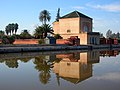
 The Saadian Tombs
 -
 The Koutoubia Mosque
 -
 Djemaa el Fna square by night
 -
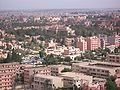 A view from a hill
 -

-
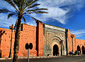 Bab Agnaou city gate
 -
 Djemaa el Fna in the evening
 -
 Marrakech riad courtyard
 -
 Wall of Agdal Gardens
 -

-
-
Sunset near Marrakech train station
-
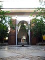
 Madrassa Ben Yusef


References and notes
- ^ a b c "Recensement Général De La Population Et De L'Habitat De 2004" (PDF). hcp.ma. Retrieved 6 January 2010.
- ^ Ready for the masses? - Daily Telegraph
- ^ Ibn Idhari, Al-bayan al-mughrib Part III, annotated Spanish translation by A. Huici Miranda, Valencia, 1963
- ^ "Contact." Atlas Blue. 15 February 2008. Retrieved on 26 June 2010.
- ^ Review of "We Are To Answer" at Music Aloud
- ^ "Climatological Information for Marrakech, Morocco", Hong Kong Observatory, 2003, web: HKO-Marrakech.
- ^ Image credit
External links
- Template:Wikitravel
- Official site of the city of Marrakech (Arabic, French)
- Site of the city of Marrakech (English)
| Northern | ||
|---|---|---|
| Central |
| |
| Southern |
| |
Template:Historic Capitals of the Arab Empire